.gif) |
| During one of my Munich tours |
David Heath is the creator of Traces of Evil and Head of Humanities at the Bavarian International School outside Munich and Dachau. With over 25 years of experience as a history educator and IBDP examiner, he specialises in the Third Reich, the Holocaust, and the Second World War. Established nearly two decades ago, Traces of Evil serves as a comprehensive digital archive that makes the geography of the Third Reich tangible for students, educators, and historians. Through thousands of then-and-now photographs and animated GIFs, mostly taken while cycling to the locations, the site juxtaposes modern images of historic sites with their archival counterparts. These visual comparisons span from ancient history through to the Nazi era and are supported by primary source documents, film footage, and survivor accounts. As an educator accredited by the Dachau Memorial Site and a licensed tour guide, Heath has gained unique access to important locations such as the Führerbau and Hitler’s apartment on Prinzregentenplatz. He has developed the platform to provide high-quality teaching resources aligned with GCSE, A-Level, and International Baccalaureate Diploma Programme curricula. These include detailed lesson plans on the Weimar Republic and the rise of Hitler, graded student responses, and examination-style questions drawn from his extensive classroom experience. His work is validated by certification from Yad Vashem, was awarded the Outstanding High School Teacher Award from the University of Chicago (2006), and the ITC Teacher of the Year award (recommended by the University of Cambridge, 2009). Heath has been featured in numerous publications including the national Süddeutsche Zeitung and has presented at conferences such as the Association of German International Schools.
GERMANY

Hitler's Bunker and Reich Chancellery: Corporeal Decay and Erasure
Given the extensive destruction and reconstruction of the area, I focus on corporeal decay: Hitler’s tremors, Eva Braun’s presence, the Goebbels children’s poisoning, and the charred remains ignited in the Chancellery garden. Such visceral details, paired with forensic analysis of bloodstained sofas and contested skull fragments, strip away myth to expose raw desperation. Central are the visual confrontations; archival schematics map the Vorbunker’s warren-like layout beside contemporary photographs—my students dwarfed by overgrown foundations, the emergency exit choked by weeds—to underscore terrain irrevocably altered yet hauntingly resonant. Provocation emerges through dissonance- footage of Churchill scrutinising the ruins in 1945 collides with modern re-enactments, whilst STASI film from 1988 reveals flooded corridors mere years before redevelopment entombed them beneath parking lots. Soviet troops hauling away a Reich eagle with Groucho Marx’s Charleston atop Hitler’s grave. Degussa’s anti-graffiti coating on Holocaust Memorial stelae-produced by the firm behind Zyklon B. Through it all I try to frame the Führerbunker not as inert stone but as a palimpsest where ideology, erasure, and frail humanity collide.

The Brandenburg Gate and Reichstag: Architecture, Power, and Memory
This page focuses on the Brandenburg Gate and Reichstag, using archival images, student photographs from my class trips over decades, and detailed historical commentary to show how architecture, power, and memory intersect in one of Europe’s most contested cities. It traces the Gate’s transformation from imperial symbol to Nazi propaganda tool then through wartime ruin, Cold War division as part of the Berlin Wall’s death strip, and post-1989 reunification. The Reichstag’s examined through pivotal moments: the 1918 republic proclamation, the 1933 fire and debate over Nazi involvement, its capture in 1945, and post-war use as a museum before Lord Foster’s reconstruction. The site’s Soviet-era graffiti is presented as raw testimony of conquest and memory. I also include analysis of manipulated photographs, challenging mythologised narratives and document wartime destruction, the fate of buildings like the Adlon Hotel and Palais Arnim, and lesser-known stories such as the Kapp Putsch, the Volkssturm, and individual figures like Marija Limanskaja using primary sources, academic works, and eyewitness accounts. The juxtaposition of my students at these sites with historical events creates a direct link between past and present.
.gif)
Unter den Linden: The Nazis' Ceremonial Boulevard
My exploration of Unter den Linden examines Berlin's ceremonial boulevard as a palimpsest of competing historical narratives, from Prussian grandeur through Nazi spectacle to divided city and reunified capital. I trace the street's transformation using archival photographs, Nazi-era postcards, and contemporary visits with my students, documenting how monumental spaces designed for mass rallies have become sites of amnesia and ambiguity. Through then-and-now comparisons, I reveal the Neue Wache's evolution from Prussian guardhouse to Wehrmacht shrine to DDR memorial, now housing an enlarged Kollwitz pietà that conflates perpetrators with victims under the vague dedication "To the Victims of War and Tyranny." My look at Bebelplatz integrates footage of the 1933 book burning with images of today's subtle underground memorial, demonstrating how the square that witnessed Goebbels's "cleansing by fire" now hosts tourists who often miss Micha Ullmann's subterranean empty library. I bring to life the Lustgarten's transformation from site of million-strong Nazi rallies using photographs of Hitler addressing the SA alongside images of my students standing where tanks defended the Museum Island in 1945. My coverage extends to contested reconstructions: the Stadtschloss rising where the Palast der Republik once stood, the Alte Kommandantur's "bogus neo-Renaissance front" concealing modern offices, and debates over authentic preservation versus Disneyfication. Through images of wedding ceremonies at the Dom draped in swastikas, the Armistice railway carriage displayed as trophy, and Great War tanks pressed into final service, I demonstrate how the street served as theatrical backdrop for Nazi power. My juxtaposition of Wehrmacht honour guards with schoolchildren, demolished ruins with pristine façades, reveals Berlin's approach to its difficult past: neither honest preservation nor complete erasure, but selective reconstruction that smooths over historical ruptures.

Wilhelmstraße: The Nazi Government District
Lined with imposing buildings and government offices, Wilhelmstraße was the epicentre of Nazi governance, housing key institutions and ministries essential to the regime's control. Among these were the offices of the Reich Chancellery and Goebbels's Ministry of Propaganda which played a crucial role in shaping public opinion and disseminating Nazi ideology. Here I guide you down the street’s historical significance as a metonym for the German Reich government, focusing on the Reich Aviation Ministry, the only major Nazi-era building still standing, and the Gestapo headquarters, now the Topography of Terror exposing the bureaucratic machinery of Nazi terror. The Aviation Ministry stands as a monumental relic of Nazi ambition, its stark limestone façade and vast scale embodying the regime and today serving the Federal Ministry of Finance, raising questions about repurposing structures tied to oppression. Equally significant is the Berlin Wall’s presence along Wilhelmstraße, which marked the Cold War divide between East and West. My GIFs contrast the Wall’s imposing barrier in 1990 with its remnants today, underscoring the street’s layered history of division and trauma. The Wilhelmstraße History Mile, with glass information boards, attempts to contextualise sites like the Reich Colonial Office, where the Herero and Nama genocide was orchestrated. By weaving these visual comparisons into its narrative, I challenge my students to reflect on how Berlin navigates its complex legacy, balancing preservation, erasure, and the enduring weight of history’s atrocities.

Friedrichstraße: Commerce and State Terror
By focusing on Friedrichstrasse I examine Berlin's north-south artery as a continuum of state terror, from Nazi deportations through Cold War division to contemporary commercial amnesia. I present the street through an analysis of Battle of Berlin photographs—identifying specific vehicles, units, and casualties, the half-track of ϟϟ-Hauptsturmführer Pehrsson, the bright red Bergmann Deutsche Reichspost van, Swedish volunteers' corpses arranged for propaganda effect— Soviet documentation, and contemporary visits with my students, to reveal how successive regimes weaponised this street. My then-and-now comparisons trace the station's evolution from deportation point for Jews to the DDR's "Tränenpalast" where families were torn apart at the heavily guarded transit point between East and West. I document the Reichsbahnbunker's transformation from forced-labour construction to NKVD prison to "banana bunker" to luxury penthouse, each iteration erasing previous histories. Through archival footage and contemporary photographs, I show how the street served both regimes: the Gestapo's surveillance of travellers, mass deportations continuing even under Allied bombardment, then the Stasi's control of the few permitted crossing points. My focus on Checkpoint Charlie extends beyond Cold War clichés to examine its commercialisation—from the 1961 tank standoff to today's costumed guards posing for tourist selfies. I juxtapose Peter Fechter bleeding to death in no-man's land with souvenir shops selling Wall fragments, Wehrmacht parades with James Bond film locations. The systematic documentation of wartime destruction—Soviet artillery coordinates, casualty figures, building-by-building combat—contrasts with the street's current incarnation as shopping destination and tourist trap. Through identification of corpses and commercial façades, I present Friedrichstrasse as where state terror's infrastructure becomes retail therapy's playground.

Tiergarten: Memorials, Resistance, and the Germania Masterplan
Tiergarten is where Nazi ideology, wartime destruction, and postwar memorialisation intersect along Berlin's diplomatic quarter. I document the Soviet War Memorial on Straße des 17. Juni using archival photographs from 1945 and class visits, showing how this monument built from materials allegedly taken from Hitler's Chancellery sits provocatively in the former British sector, tracing its construction in November 1945 when Zhukov refused to request British permission, its role during the Cold War when Soviet honour guards from East Berlin stood watch in West Berlin, and incidents including the 1970 shooting of a guard by neo-Nazi Ekkehard Weil. At Tiergartenstraße 4, I document the headquarters of the T4 euthanasia programme through visits to the site now occupied by a rusted metal memorial, detailing how from this address Hitler's secret order led to the murder of over 70,000 disabled patients before personnel were transferred to implement the Final Solution. I examine the fascist embassies built between 1938 and 1943 as compensation for demolitions required by Speer's Germania plans. Through images of the Victory Column's 1938 relocation for the east-west axis, wartime damage, and visits with students, I show how the monument survived despite French attempts at vandalism. At the Bendlerblock, I document the site of the July 20 plot through photos of Stauffenberg's office with its surviving swastika parquet, the courtyard where conspirators were executed, and Scheibe's memorial statue created by an artist who received both Nazi and Federal honours. I reveal again how Tiergarten's monuments and buildings embody Berlin's layered history: Soviet victors occupying space planned for Germania, euthanasia headquarters marked by abstract sculpture, fascist embassies retaining their authoritarian symbols, and military buildings where resistance came too late transformed into memorial sites that obscure as much as they reveal.
Berlin's Western Districts: Ruin, Resistance, and Terror Infrastructure
I start this page by tracing Kaiser Wilhelm Memorial Church from imperial monument through British bombing to preserved ruin, showing how Egon Eiermann's modernist church coexists uneasily with the hollow tower where Coventry's Cross of Nails now stands as reciprocal symbols of destruction. I document Plötzensee Prison's execution shed where over 2,500 died, including July 20 plotters hanged from meat hooks whilst cameras rolled for Hitler's viewing pleasure, the memorial created by sculptor Richard Scheibe who received both Nazi and Federal honours. My look at Anhalter Bahnhof juxtaposes Hitler's triumphant return from France with the station's use deporting 9,600 Jews, the adjacent bunker that housed 12,000 during Berlin's fall now containing controversial Hitler room reconstructions. At Karlshorst, I show where Keitel signed Germany's surrender, his monocle dropping before Zhukov in the former military canteen. Through systematic comparison of execution protocols, deportation logistics, and architectural survivals, I demonstrate how Berlin today transforms terror infrastructure into commercial normality, revealing through specific locations how the city neither preserves honestly nor erases completely, creating instead a landscape where Nazi eagles persist on pharmacies whilst memorial plaques proliferate, where each site embodies Germany's continuing inability to reconcile preservation with progress, memory with amnesia.

The Reichssportfeld: Ideological Theatre and the 1936 Olympics
This page looks at how Berlin's Olympic Stadium complex, conceived for the cancelled 1916 Games, was transformed by Werner March into a limestone colossus for the most spectacular propaganda exercise ever staged by the Nazis. Using archival footage, Nazi-era postcards, and then-and-now GIFs, I trace the stadium's evolution from athletic venue to ideological theatre. I document the surviving Nazi sculptures and analyse how these remain displayed without contextualisation. Through comparisons of the Führerbalkon where Hitler watched Jesse Owens triumph, the bell tower where the Olympic bell still bears its half-heartedly defaced swastika, and the Langemarck Hall celebrating military sacrifice, I reveal how the complex served dual purposes: impressing foreign visitors whilst preparing for war. I examine the torch relay's invention here, running from Greece through territories soon to be invaded, and Riefenstahl's Olympia which transformed the Games into cinematic myth. I examine the Olympic Village, Hitler's "village of peace" that became Wehrmacht barracks then KGB torture facility, and where 20,000 watched Nazi Thingspiel productions beneath Wamper's reliefs that still flank the entrance. I conclude at the Commonwealth War Graves Cemetery where my great-grandfather lies, having died in 1950 helping rebuild the democracy on the ruins of the regime that hosted these Games five years helping to destroy. Here I'll show you how Berlin's Olympic complex embodies Germany's selective preservation: Nazi sculptures remain as "art", the bell tower was faithfully reconstructed, yet interpretive silence allows the site to function as mere sports venue rather than confronting its role in legitimising a regime that would soon engulf the world in war.
.gif)
Wannsee: The Bureaucracy of Genocide and the Final Solution
Here's my detailed examination of the Wannsee Conference, held on January 20, 1942 in a luxurious villa by Berlin’s Wannsee lake, to reveal its chilling role in coordinating the Nazi genocide. The site, now the House of the Wannsee Conference memorial and educational centre, meticulously documents the meeting where Reinhard Heydrich, Adolf Eichmann, and other senior Nazi officials planned the "Final Solution" to exterminate Europe’s Jews. Through archival records, then-and-now photographs, and survivor testimonies films and graphic novels, I trace how the conference clarified responsibilities for deportations and mass killings, integrating existing extermination efforts with bureaucratic precision. The villa’s serene setting contrasts starkly with the horrific decisions made within, a juxtaposition captured in my images showing the preserved conference room alongside modern educational displays. The permanent exhibition details the systematic exclusion, ghettoisation, and extermination of Jews from 1933 to 1945, using Eichmann’s minutes, which reveal the euphemistic language of "evacuation" for murder. I explore the site’s post-war transformation, from its use by the Red Army and American forces to its rededication in 1992 as a memorial named after historian Joseph Wulf, who survived Auschwitz but later took his own life, despairing at Germany’s indifference to Holocaust memory.

Berlin's Periphery: Forced Labour, Propaganda, and the Cold War Divide
We start at Treptower Park, the Soviet Memorial, built between 1946 and 1949, commemorates 20,000 Red Army soldiers who died in the Battle of Berlin. Its colossal statue and cemetery, with then-and-now images contrasting 1956 ceremonies with modern visits, underscore its role as both a tribute to Soviet sacrifice and a symbol of Cold War tensions. The memorial’s swastika, depicted as smashed, highlights its anti-fascist narrative, yet its Soviet origins evoke debates about liberation versus occupation. In Schöneweide, the preserved Nazi forced labour camp at Britzer Straße exposes the grim reality of over 2,000 workers housed in barracks. Sachsenhausen, a Nazi and later KGB concentration camp, is shown through then-and-now images of its guard tower and crematorium ruins, reflecting its shift from a site of Nazi terror to a memorial confronting its layered history. The UFA Studios in Babelsberg reveal their role as a Nazi propaganda hub under Goebbels, contrasting with their post-war DEFA legacy. Fort Hahneberg is shown its military past and partial post-war demolition, whilst Tempelhof Airport’s redesign as a Nazi-era gateway reflects its propaganda role and later significance during the Berlin Airlift.

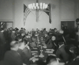
Potsdam: The Post-War Settlement and Prussian Legacies
I made the most of my access to Cecilienhof Palace, where fifteen officials spent two weeks in 1945 dividing the post-war world, to trace how the last Hohenzollern palace became the unlikely venue for determining the fate of the world. Through comparisons of wartime photos with contemporary documentation, I reveal how each delegation's quarters were colour-coded with Churchill relegated to the library whilst Stalin and Truman occupied ground-floor studies. My analysis of the conference hall shows where Truman casually informed Stalin about the atomic bomb on July 24, 1945, a moment Stalin feigned ignorance about despite Soviet intelligence having already briefed him. I examine the White Salon's transformation from Crown Prince's music room to Soviet reception space, documenting how furniture was brought from bourgeois households to create Stalin's deliberately modest æsthetic. The garden terrace where press photographers captured the "Big Three" in wicker chairs now displays those same chairs as museum pieces, whilst Christlieb's deer statues were returned only in 2020. We look beyond the palace to Potsdam's broader transformation: the Garrison Church where Hitler and Hindenburg staged their March 21, 1933 handshake, destroyed by British bombing in April 1945; the Lustgarten where Wehrmacht ceremonies occurred; KGB Military Town No. 7 with its hundred buildings and interrogation facilities.

The Beer Hall Putsch Route: Origins, Myth and Urban Transformation
Allow me to take you along Munich’s 1923 Beer Hall Putsch route where we'll traces the physical and ideological transformation of the march from the Bürgerbräukeller toward Marienplatz. I examine how the Third Reich monumentalised this path into a sacred landscape of Nazi commemorative ritual, and how post-war urban planning systematically erased or repurposed these historical sites. I analyse the structural denazification of the Ludwigsbrücke and the Deutsches Museum's suppressed history of institutional collaboration, notably its hosting of the Der ewige Jude propaganda exhibition. Moving beyond the failed coup, I investigate the spatial origins of the early Nazi apparatus along this route, from the birth of the ϟϟ inside the Hotel Torbräu to Hitler’s fateful introduction to the DAP at the Sterneckerbräu. Finally, I assess the extensive WWII bombing damage and the complex architectural debates surrounding the post-war restoration of Munich’s historic landmarks, including the mediæval Isartor.
.gif)
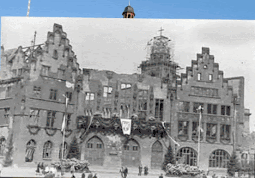
Munich's Marienplatz: Political Theatre, Kristallnacht and Reconstruction
I start from high above Munich’s Marienplatz and its surrounding environs from where I trace how the city confronted its 'tattered past', moving from a stage for Nazi spectacle to a symbol of determined post-war reconstruction. I examine the dual functions of the Neues Rathaus, which served as a backdrop for both political theatre and, post-1945, the administrative hub for the American forces, and detail how the Altes Rathaus hosted Goebbels’s infamous Kristallnacht speech. I go beyond the square to explore the sites of Nazi atrocities and early party organisation, from the Aryanisation and persecution of Jewish businesses on Kaufingerstraße. I examine the public debate over whether to preserve ruins or recreate pre-war identity which represent a deliberate and at times contested effort to overcome the war's devastation and the historical memory of the Third Reich, as shown by the post-war memorials to German prisoners of war which preceded any similar plaques for Nazi victims. Along the way I explore the roles of key figures like Rupert Mayer, who opposed the regime from a church now containing his tomb, and the police headquarters on Ettstraße, a site of early Nazi terror bureaucracy.
.gif)
Königsplatz: The Teatrum Sacrum of the Nazi Movement
Again we start this page literally high above Munich’s Königsplatz to examine the symbolic heart of the Nazi movement. We look at how the site, originally a 19th-century neoclassical ensemble honouring art and antiquity, was transformed under the Nazis into a monumental Teatrum sacrum as a stage for ideological ritual. Using archival images, then-and-now images, and historical analysis, see how the square became central to Nazi myth-making, hosting annual commemorations, and parades. The site’s complex legacy is further illustrated through events like the 1933 book burnings, the American occupation, and the Monuments Men’s work restoring looted art. Today, overgrown temple foundations and subtle plaques mark a deliberate effort to ignore the past and so my webpage serves as a case study in how cities confront dark histories, showing Königsplatz not just as a physical space, but as a contested symbol of memory, ideology, and architectural power.

The Führerbau: Diplomatic Betrayal and the Munich Agreement
This exhaustive then-and-now documentation centres on the Führerbau at Arcisstraße 12, the exact building where Chamberlain, Daladier, Hitler and Mussolini signed the Munich Agreement in the early hours of September 30, 1938, dismantling Czechoslovakia and marking the zenith of appeasement. I again enjoyed the rare opportunity to explore the site to take then-and-now photos to present precise superimpositions of the conference photographs onto the identical rooms today, including Hitler’s office, the large reception hall with its still-intact monumental fireplace, the grand marble staircase, the radiators with original wooden covers, and the balcony from which Hitler and Mussolini appeared to the crowds. It details the building’s architecture by Troost to the post-war American substitution of the Nazi eagle with the bald eagle, and the building’s later use as Amerika-Haus. Extensive historical commentary and rare archival footage stills explain how Munich represented both Hitler’s greatest diplomatic triumph and his private fury at being denied war. The page extends to the twin Verwaltungsbau, its intact library, the underground connecting tunnel, the post-war looting, the Monuments Men operations, and the fate of the eight-million-strong party membership card index saved from destruction. It concludes with the wider Königsplatz complex: the demolished Ehrentempel foundations, the camouflaged buildings during the war, and the ideological transformation of the entire Nazi party centre into institutions of culture and remembrance.

Munich's Parteizentrum: The Ehrentempel Ruins and the Architecture of Party Bureaucracy
My examination of the Parteizentrum der NSDA focuses on the administrative and cultic core of the Nazi movement situated adjacent to Königsplatz. Through precise then-and-now photographic alignments, I document the overgrown limestone foundations of the Ehrentempel, constructed by Paul Ludwig Troost to house the sarcophagi of the sixteen 1923 putschists. I contrast archival records of their 1935 consecration and the annual November 9 blood cult rituals with the structures' post-war demolition by the US Army in 1947 and their current state of deliberate neglect. Adjacent to these ruins, I analyse the surviving Verwaltungsbau, which housed the party's central bureaucracy and the subterranean vaults designed to protect millions of NSDAP membership cards. The research extends along Meiserstraße (now Katharina-von-Bora-Straße), charting the sprawling network of mundane office buildings- including the Zentrale with its Nazi reliefs still in place- and various treasury departments, that managed the logistics, finance, and personnel of the totalitarian state. By isolating these administrative and memorial structures from the primary diplomatic staging ground of the Führerbau, I try to expose the stark physical contrast between the regime’s monumental ideological shrines and the surviving bureaucratic infrastructure that facilitated its daily operations.Sites featured: Ehrentempel foundations, Verwaltungsbau (Central Institute for Art History), Parteizentrum der NSDAP, Meiserstraße (Katharina-von-Bora-Straße) administrative offices, NSDAP Zentrale, Brienner Straße.

Odeonsplatz: The Altar of the Movement and the Cult of Martyrs
The focus of this page is Munich’s Odeonsplatz and the Feldherrnhalle as a key site of Nazi myth-making, tracing the site’s transformation from a 19th-century military memorial into the Nazis' “Altar of the Movement” after the failed 1923 Beer Hall Putsch. Through my GIFs and archival material, I show how the Nazis repurposed the site for annual commemorations, complete with ϟϟ guards, mandatory Hitler salutes, and the display of the blutfahne. I research the propaganda machinery behind the cult of the sixteen “martyrs,” including the 1935 reburial ceremony and the construction of the Temples of Honour on Königsplatz whilst presenting counter-memories: the police officers killed resisting the putsch, their memorial’s removal, and later attempts to revise the past, such as Reinhold Elstner’s 1995 self-immolation. The site’s post-war evolution is covered, including the dismantling of Nazi symbols, the unofficial “Shirker’s Alley” where locals avoided saluting, and graffiti like “I am ashamed to be a German.” I critically engage with contested imagery, such as the disputed photo of Hitler in the 1914 war rally, and include artistic representations, political protests, and modern-day tensions over remembrance to use the site as a case study in how public space is weaponised for ideology and how societies grapple with its legacy.
.gif)
.gif)
Munich's Adolf-Hitler-Straße: The Corridor of Nazi Authority
Munich’s Brienner Straße, once renamed Adolf-Hitler-Straße, was transformed from a 19th century boulevard into a corridor of Nazi authority. My visual comparisons contrast the street’s elegant façades with their wartime devastation and post-war reinvention, highlighting sites like the Wittelsbacher Palais, which housed Gestapo headquarters and became a symbol of terror, where many faced execution. Next door was Hitler's planned mausoleum and he Haus der Deutschen Ärzte, the epicentre of Nazi medical policy and the Holocaust’s grim beginnings. This building housed the Reich Physicians’ Chamber, where racial laws and the T4 euthanasia programme were devised and implemented, leading to the forced sterilisation and murder of hundreds of thousands deemed “unworthy of life.” The building’s architecture and symbolism reinforced the regime’s racial ideology, making it a chilling monument to state-sponsored medical atrocities. I trace the Brown House, the Nazi Party’s nerve centre, where Hitler orchestrated his rise, and the Palais Törring, site of the Supreme Party Court, underscoring the regime’s internal mechanisms of control. I critique the persistence of Nazi symbols, like the altered eagle on surviving buildings, and debates over memorials, such as the Platz der Opfer des Nationalsozialismus, questioning how such spaces confront or conceal historical complicity by being purposely vague and obfuscating the past, and attack the current NS-Dokumentation Zentrum's director's focus on kowtowing to current Woke fetishes rather than the history it purports to document.

Schellingstraße and the Kunstareal: Nazi Origins, Bohemian Life and Post-war Reconstruction
I investigate Munich's Maxvorstadt, focusing on the interconnected histories of Schellingstraße and the adjacent Kunstareal. I document the area's role as the administrative cradle of the early Nazi Party, from the party headquarters at Schellingstraße 50 where the Reich-wide apparatus was organised, to the nearby offices of the Völkischer Beobachter propaganda newspaper and the Sicherheitsdienst (SD) under Reinhard Heydrich. This political history is juxtaposed with the area's legacy as a centre of Schwabing's bohemian life, exploring the legendary cafes like the Schelling Salon and Osteria Italiana where figures such as Hitler and Lenin coexisted uneasily with artists and intellectuals like Bertolt Brecht and Oskar Maria Graf. The analysis then turns to the wartime devastation and complex post-war reconstruction of the Kunstareal, detailing the destruction of the Alte and Neue Pinakotheken and the pivotal architectural debate between traditionalists and modernists over their restoration. I focus on Hans Döllgast's celebrated reconstruction of the Alte Pinakothek and the deliberate preservation of war damage, such as the bullet holes on the Rosselenker sculpture, as 'scars of remembrance'. Finally, I examine individual acts of resistance and persecution within this quarter, including Georg Elser's preparations for his assassination attempt and the fate of performer Fritz Gruenbaum, arrested after a satirical routine at the Alter Simpl.
Munich's Ludwigstraße: Bureaucracy, Indoctrination and Resistance
Ludwigstraße housed key institutions and buildings that served various functions during the Third Reich. Among them the Landeszentralbank, as Bavaria's central bank, managed financial affairs crucial to the Nazi war effort, whilst the Kriegsministerium, oversaw military operations and strategic planning during the war. Munich University became a centre for Nazi propaganda and indoctrination, influencing professors and students alike. Haus Deutschen Rechts accommodated legal bodies instrumental in enforcing Nazi laws, whilst the Staatsbibliothek provided resources for Nazi propaganda and ideological research. The Staatsministerium facilitated the implementation of Nazi policies at the regional level, and the Siegestor, a triumphal arch, symbolised German nationalism and militarism. The Bayerisches Staatsministerium des Innern oversaw internal security and law enforcement, whilst the Zentralministerium für den gleichgeschalteten bayerischen Staat centralised control over Bavarian government agencies under Nazi rule.
.gif)
Munich's Stachus: Justice, Finance and Exclusion
Various sites within walking distance between Munich's Karlstor and the main railway station. Park Café in the Old Botanical Garden served as a social hub during the Nazi period, frequented by both citizens and party officials. Nearby, the central railway station, facilitated the transportation of troops, supplies, and prisoners to and from Munich, playing a logistical role in Nazi operations. The Oberfinanzpräsidium administered financial affairs in the region under Nazi control, overseeing taxation and economic policies and still boasts the largest Nazi eagle in the city. The Justizpalast near Karlsplatz is renowned for hosting the Volksgerichtshof trials, where numerous anti-Nazi conspirators, including members of the White Rose resistance group, faced prosecution. The Ausstellungspavillon, the first Nazi edifice, hosted Nazi exhibitions and displays promoting racial superiority and militaristic ideals. Additionally, remnants of Nazi eagles and statues around the area serve as stark reminders of the regime's propaganda. The Main Synagogue, destroyed months before Kristallnacht, marks a site of profound loss and remembrance. Collectively, these sites around Stachus not only highlight Munich's architectural and cultural history but also its dark chapter under Nazi influence.

Central Munich: Propaganda, Aryanisation and Everyday Life
Munich's Hofbräuhaus emerged as a pivotal site for Hitler and the Nazi Party, serving to galvanise support for the Nazi movement among the populace, marking it as a symbolic venue for the propagation of Nazi ideology and political mobilisation. The nearby Pfeffermühle cabaret was a hub for anti-Nazi satire, offering a platform for performances that subtly critiqued the regime, symbolising the underground resistance in Munich. The Arisierungsstelle played a key role in the confiscation and forced sale of Jewish-owned businesses and properties as part of Nazi racial policies. The Nordbad, a public swimming pool, was emblematic of the Nazi emphasis on physical fitness and public health, serving as a site for the regime’s ideological propagation. Munich's Opera House, a cultural landmark, was often used for Nazi propaganda events and attended by high-ranking officials, reflecting the regime's efforts to intertwine culture with their political agenda. Hitler’s Residence in Munich served as a personal and political headquarters for Hitler, where numerous strategic decisions were made particularly after the Munich Agreement was signed.
.gif)
Munich's Cultural Landscape: Science, Militarism, and Appropriation
Among the sites featured are the Deutschen Museum, one of the largest science and technology museums in the world, was utilised by the Nazi regime for propaganda purposes, showcasing achievements in German science and technology to promote the regime's image of progress and superiority. The Löwenbräukeller was a venue frequented by Hitler and the Nazi Party for political meetings and rallies. Oktoberfest, an annual beer festival held in Munich, was appropriated by the Nazis as a celebration of German nationalism and cultural identity, with propaganda displays and events promoting Nazi ideology. The Freikorpsdenkmal, a monument in Munich commemorating the Freikorps soldiers who fought in the early 20th century, was appropriated by the Nazis as a symbol of militarism and nationalism, glorifying the paramilitary groups that paved the way for Hitler's rise to power.
.gif)
More Nazi-era sites around Munich: Prisons, Airfields and the Politics of Sport
Another sprawling page of Nazi-related sites in Munich including Nymphenburg Palace, repurposed by the Nazi regime for various functions, including hosting official receptions and ceremonies to bolster the regime's image of power and grandeur. Stadelheim Prison, used as a detention facility for political prisoners, resistance fighters, and other perceived enemies of the regime, where many were subjected to harsh conditions and torture. The Reichsfinanzhof was responsible for overseeing financial matters and taxation policies under the Nazi regime, playing a crucial role in funding the regime's activities and war effort. The Reichszeugmeisterei was responsible for overseeing the production and distribution of uniforms and equipment for the Nazi military and paramilitary organisations, ensuring uniformity and adherence to Nazi standards. Flughafen Oberwiesenfeld was an airfield used by the Nazis for military purposes, including training pilots and conducting reconnaissance flights. Much is devoted to football under the Third Reich.
.gif)
.gif)
Munich's Nazi Graves: Perpetrators, Victims, and Contested Remembrance
A virtual tour around Munich’s principal cemeteries, including the Nordfriedhof and Waldfriedhof, seeing these sites as complex repositories of the city’s twentieth-century history. Using my own then-and-now photography and historical analysis, I document the final resting places of the Third Reich's most significant figures, from high-ranking perpetrators such as Ernst Röhm and Paul Ludwig Troost to cultural icons like Leni Riefenstahl and victims of the regime like Gustav von Kahr. The work juxtaposes the grand state funerals of the era, such as those for General Dietl, with the quiet, often unassuming graves of today, creating a visual dialogue between past propaganda and present-day remembrance. I also document the graves of collaborators, resistance figures, and those whose legacies remain deeply contested, revealing how these burial grounds serve as a microcosm of the period's moral and political conflicts. By presenting these individuals, from Hitler’s chauffeur Emil Maurice to the philosopher Oswald Spengler, within their final, shared landscapes, my examination offers a unique perspective on the intertwined fates of the era’s key players and how their legacies are confronted, or ignored, in modern Munich.
.gif)
Lenin in Munich: The Ideological Crossroads of Schwabing
This webpage traces Munich’s dual role as a crucible for both Lenin’s revolutionary ideology and Hitler’s nascent fascist vision, framing the city as an unlikely intersection of 20th-century political cataclysm. Focusing on Schwabing’s Schleissheimer Strasse, it underscores the remarkable proximity of their residences —Lenin at #106 (1900–1902) and Hitler at #34 (1913–1914)—to argue Gellately's point that Lenin created the system Hitler would impose. Now stripped of plaques commemorating their infamous inhabitants, Lenin’s Munich years are reconstructed: his aliases, clandestine publishing of Iskra from cramped apartments, and debates with figures like Rosa Luxemburg and Georgy Plekhanov, which crystallised his vanguard party theory. I emphasise his tactical ingenuity—smuggling literature via Stuttgart printers, forging Bulgarian passports, and leveraging Munich’s relative political stability—whilst situating his intellectual labour within the city’s physical fabric. Hitler’s presence is framed through his transient, almost mundane existence in the same streets and cafes: sketching, avoiding rent payments, and absorbing the nationalist fervour of pre-war Munich. Here the mundane logistics of revolution (printing presses, postal addresses) and the banality of daily life (Lenin’s influenza, Hitler’s tailor-made suits, both using the Schelling Salon's urinals) underpin grand historical narratives. By mapping their movements, from Lenin’s library research at Ludwigstrasse to Hitler’s coffeehouse rants, I would argue for Schwabing to be considered a microcosm of Europe’s ideological fractures.
.gif)
Dachau Concentration Camp: Model Camp, Memorial and Contested Legacy
Given rare access to the memorial site and surrounding ϟϟ compund now used by the Bavarian Ript Police both as a certified guide at the site and an history teacher nearby, I was able to offer this detailed exploration of the Dachau concentration camp and its surrounding historical sites, moving beyond a simple summary of atrocities to an examination of the camp's architectural, ideological, and post-war legacy. Exploiting my links with the memorial site, I highlight how the camp served as a model for the entire Nazi system, with its infamous ‘Arbeit macht frei’ motto and methodical design, but it also delves into the cynical and sadistic realities that belied this propaganda. Through powerful then-and-now visual comparisons, my page juxtaposes images of the camp during its operation and liberation with its present-day appearance, highlighting both the deliberate reconstruction of key features like the gate and watchtowers, and the subtle, and sometimes not so subtle, signs of the past’s contested legacy, such as a Confederate flag flying on the former ϟϟ residence of Adolf Eichmann. I draw attention to the ongoing debates over how to commemorate victims, such as the exclusion of homosexuals, ‘asocials’, and common criminals from some memorials. I also include nearby sites like the Hebertshausen shooting range, where 4,000 Soviet prisoners were murdered, and the ‘plantation’ where slave labour was exploited for pseudo-scientific agricultural projects. Through this I reveal the complexities and controversies that have long surrounded Dachau, from the American soldiers' summary executions of guards upon liberation to the subsequent denial and selective remembrance that shaped the memorialisation of the site.

Dachau Town: Local Complicity and the Shadow of the Camp
This page moves beyond the infamous concentration camp to reveal the complex and often contradictory history of the municipality itself. The narrative focuses on how Dachau, a predominantly working-class town with strong leftist sympathies, was co-opted and then reshaped by the Nazi regime. I highlight this ideological struggle by referencing places like the Hörhammerbräu Inn, once a stronghold for communists, which later became a meeting place for the local Nazi Party. My page discusses the complicity and resistance of the town's residents showing how local authorities enthusiastically embraced the Nazi regime, renaming streets and granting Hitler honorary citizenship, whilst also detailing the courageous actions of individuals who risked their lives to help prisoners. My page also presents a sober look at the aftermath of the war, including the summary executions of ϟϟ guards and the difficult process of memorialising the victims of the ‘death marches’ in places like the Leitenberg cemetery. Ultimately I present Dachau as a microcosm of Germany’s turbulent 20th century, where the political and social fabric of a community was permanently scarred by its proximity to the brutal realities of Nazism.
.gif)
Nuremberg Nazi Party Rally Grounds: Architecture, Propaganda and Memory
Offering a detailed, on-the-ground exploration of Nuremberg’s Nazi Party rally grounds, using historical photographs, archival sources, and images from numerous visits to examine how the city was transformed into a stage for Nazi propaganda. I focus on key sites like the Zeppelin Field, Congress Hall, and Luitpold Arena, showing how Speer’s monumental architecture was designed to overwhelm and indoctrinate. The page documents the annual rallies from 1927 to 1938, their role in promoting the Nuremberg Laws, and the choreographed displays of loyalty involving the SA, ϟϟ, and Hitler Youth. It includes analysis of Leni Riefenstahl’s Triumph of the Will, draws parallels to later cultural imagery including Star Wars and Gladiator, and examines surviving structures like the Zeppelin Tribune and transformer station, now repurposed or decaying. The site’s post-war use as a US military base, sports venue, and location for fast food is contrasted with ongoing debates about preservation, memory, and the ethics of maintaining Nazi architecture. The Documentation Centre in the Congress Hall’s northern wing is highlighted as a key educational resource, presenting the history of the rallies, the regime’s crimes, and the challenges of confronting this legacy.

.gif) Berchtesgaden, Obersalzberg & the Eagle's Nest: The Alpine Nerve Centre of the Third Reich
Berchtesgaden, Obersalzberg & the Eagle's Nest: The Alpine Nerve Centre of the Third Reich
.gif) Nazi Sites around Berchtesgaden: The Satellite Landscape of the Führer’s Mountain Headquarters
Nazi Sites around Berchtesgaden: The Satellite Landscape of the Führer’s Mountain Headquarters
.gif) Schleißheim: Looted Art, Air Power and Forced Labour
Schleißheim: Looted Art, Air Power and Forced Labour
.")
Freising: Nazification, Persecution and Post-war Ambiguity

Landkreis Freising's Nazi Legacy: Death March Routes, Anti-Nazi Resistance, and Historical Erasure
My page focused on local history around Freising which involves stories of anti-Nazi resistance, including Major Alois Braun's Freiheitsaktion Bayern headquarters in Pettenbrunn and the courageous schoolboys of Hohenkammer who defied the regime. The post documents the inhuman final days of the Third Reich, mapping the brutal Buchenwald and Dachau death march routes through Tüntenhausen, Zolling, Attenkirchen, and Haag an der Amper, where memorials now honour the victims of ϟϟ atrocities. Uncover lesser-known wartime events such as the lynching of American B-24 airmen near Aign, Ferdinand Marian's fatal crash in Dürneck following his role in Jud Süß, and the suppression of left-wing Naturfreunde centres in Hangenham. The guide also examines the Dachau subcamp at Neufahrn, where forced labourers built an unfinished runway, and the controversial Bronze Age site at Bernstorf. Once hailed as the Bavarian Troy, the Bernstorf gold and amber finds remain at the centre of a fierce archaeological forgery debate.Sites Featured: Bernstorf, Kranzberg, Neufahrn bei Freising, Pettenbrunn, Neufahrn, Allershausen, Aign, Hohenkammer, Zolling, Dürneck, Hallbergmoos, Fürholzen, Eching, Kloster Wies, Hangenham


.gif)


.gif)
.gif)


Middle Franconia: Festive Complicity, Desecrated Cemeteries, and Roman Frontier
Another page illustrating Middle Franconia varied
roles in supporting the Nazi apparatus, but with a special focus on the enduring weight of memory starting with Dinkelsbühl’s
Kinderzeche festival, commemorating a legendary 1632 surrender to
Swedish troops, re-enacted annually with residents in period costume,
juxtaposed against chilling then-and-now images that uncover the town’s
fervent Nazi support, with electoral records showing 67.5% Nazi votes in
1933 against a national 43.9%. These visuals, paired with archival
postcards, contrast festive traditions with the stark reality of the
town’s embrace of Nazi ideology, evident in events like the 1933 glider
christenings named for Hitler. Then to Gunzenhausen, where then-and-now
photographs of the market square, once Adolf-Hitler-Platz, and the
desecrated Jewish cemetery highlight a community complicit in
anti-Semitic violence, notably the 1934 pogrom where two Jews died amid
mob attacks. Weißenburg’s Roman fort Biriciana is meticulously
documented through reconstructions and then-and-now images, revealing
its 2nd-century grandeur alongside its modern archaeological
significance, whilst the town’s Nazi-era renaming of streets underscores
its political alignment. Ermetzhofen’s Jewish cemetery, with its
neoclassical gravestones and symbols like the Kohanim hands, stands as a
testament to a vanished community, its history laid bare through images
contrasting past vibrancy with present desolation. Through these visual
comparisons, the content not only preserves historical traces but also
confronts the moral complexities of a region shaped by celebration,
complicity, and loss..gif)
.gif)
Augsburg: Megalomania, War Production, and the Unrealised Gauforum
.gif)


Lower Saxony: Hitler's Citizenship, Blood and Soil, and Bergen-Belsen

.gif)
.gif "Hotel Handelshof Hitler Mussolini Nazis")
.gif)
.gif)
Westphalia: Torch-lit Parades, Total Destruction, and T4 Euthanasia
Aachen’s cathedral—once draped in swastikas for Hitler’s 1932 rally—are merged with the same stones scarred by American artillery in October 1944, asking what continuity remains when the fabric of memory is rebuilt from rubble. I follow the torch-lit parades in Krefeld down Adolf-Hitler-Straße, the burning of two synagogues, and the first deportation train of 1,007 Jews freezing toward Rumbula. The page documents how Jülich, 97 % flattened in a single November 1944 raid, became the backdrop for Churchill surveying ruins whilst Goebbels shamelessly compared him to Nero. I embed the transformation of Schloss Nordkirchen into a Nazi leadership school, its Versailles façade now a Belgian art depot, and show how Warstein’s psychiatric hospital shipped 1,575 patients to Hadamar under the guise of euthanasia. I end with Wesel’s 97 % destruction followed by Operation Varsity’s airborne landings, and Duisburg’s “Victory Bridge” thrown across the Rhine in six days, leaving the city’s swastika-eagles defaced but still perched above the rebuilt streets.
.gif)
The Rhineland: Nazification, the Bridge at Remagen, and Contested Monuments
This page documents the methodical process of Nazification, from the hoisting of swastika flags on Speyer’s rathaus to the establishment of Gestapo headquarters in Trier’s Hauptwache and the hostile takeover of the Karl Marx Haus. I look at the architectural legacy, contrasting images of the swastika-adorned Altpörtel with its modern appearance and noting the survival of Nazi eagles on buildings like the Worms cathedral and the Finanzamt in Alzey. A significant focus is the war’s destructive climax, vividly captured by the comparison of American GIs taking cover on the heavily contested Nibelungenbrücke in Worms in March 1945 with the same peaceful scene today through my GIFs. I document pivotal events such as the capture of the Ludendorff Bridge at Remagen, the extensive bombing of Mainz, and the post-war Allied occupation. I also managed to uncover unique local histories, from the use of Bacharach’s castle as an indoctrination centre and Beilstein as a Nazi-era film set, to the controversial rebuilding of the imperial monument at Koblenz's Deutsches Eck. Here I try to use sites from Frankenthal to Donald Trump's ancestral home in Kallstadt as case studies in uncovering the layers of political violence, wartime destruction, and contested memory that lie just beneath the surface of a seemingly tranquil landscape.

The Saarland: Referendum, Repression and the Palimpsest of Power
Here I scrutinise the 1935 referendum not as liberation but as a theatre of coercion, where bishops’ salutes and Goebbels’s covert religious fronts, like the anti-Bolshevik exhibition smuggled via Geneva, exploited Catholic piety for Nazi gain. Visual comparisons chart Saarbrücken's transformation: the rathaus’s vaulted ceilings framing both Hitler’s motorcade and modern bureaucracy, or Adolf-Hitler-Straße’s renamed Bahnhofstraße, where Nazi parades once marched past the Johanneskirche’s unchanged spire. Outlining collaboration and complicity, I look at how Saarbrücken’s synagogue fell during Reichskristallnacht, whilst the Neue Bremm camp—hidden beyond the city limits—funneled thousands toward extermination. Wartime devastation is rendered starkly: Bahnhofstraße’s skeletal ruins after 1944 bombings contrast with its rebuilt uniformity, and the Ludwigskirche’s shattered nave mirrors the region’s fractured identity. Then and now sequences frame contested memory: the Winterberg Monument’s dynamited plinth, where a Nazi-lit beacon once glared toward France, now overlooks overgrown foundations; or the Saarlouis courthouse, its defiant Nazi eagle excised but the structure’s authoritarian bulk intact. I question why fascist reliefs on the Saarländisches Staatstheater or Casa Littoria lack explanatory plaques whilst the narrative lingers on absences: vanished synagogues, the Hindenburgturm’s toppled eagles, or the unmarked graves of forced labourers. Ultimately, the webpage frames this tiny region as a palimpsest of power, where Roman roads, Prussian memorials, and Nazi forums compete beneath Allied-bombed streets, a landscape demanding confrontation, not commemoration.
.gif)
Northern Germany: The Prora Megastructure, Naval Militarism, and Mass Suicide
My brief look at Schleswig-Holstein, Pomerania and Mecklenburg under Nazi rule traces a landscape reshaped by ideology, militarism and collective amnesia—swastikas draped over town halls in Kiel and Lübeck, Hitler Youth marching through Quickborn, the Thingplatz at Bad Segeberg repurposed from quarry to ideological stage. My then-and-now comparisons don't merely illustrate change; they confront the persistence of form amid shifts in meaning; the naval academy in Flensburg still stands as the “Red Castle,” its Nazi eagle preserved above the entrance, whilst Bismarck’s mausoleum, bombed in error, remains a site of pilgrimage and propaganda, visited by Hitler in 1939 as a symbolic prelude to war. The Kiel naval memorials erected to glorify sacrifice at sea now gaslit into memorials to peace underscoring a deliberate sanitisation of memory. At Prora on Rügen, the 4.5-kilometre shell of a never-completed KdF resort looms over the Baltic, a monument to failed utopianism, its scale revealing the regime’s ambition to engineer leisure as a tool of control. Sites of violence are rendered visible through absence: the Jewish cemetery in Güstrow, burned in 1938, now marked only by a wrought-iron fence; the synagogue in Neustrelitz, reduced to rubble after Kristallnacht; the anti-Semitic sign at Dangast, replaced today by grotesque parody. The forced labour camps embedded within industrial towns left no formal traces, their victims uncommemorated. In Demmin, the mass suicides of 1945, triggered by Soviet atrocities but rooted in years of Nazi indoctrination, were suppressed under East German rule, their memory buried as inconvenient. Even the liberation was marked by horror: at Woebbelin, American troops discovered a satellite camp of Neuengamme, where the dead lay unburied, and locals were forced to view the corpses.
.gif)
Baden-Württemberg: University Nazification, Deportation Ramps, and Erased Squares
We travel along the Neckar, anchoring each location in a tight weave of archival documents, eyewitness accounts, and precisely aligned then-and-now photographs. Beginning on Heidelberg’s Alte Brücke, I follow SA columns across the same stones I cycled in July 2022, before mapping the regime’s swift capture of the university, the Thingstätte’s failed pseudo-Germanic ritual, and the uneasy afterlife of Führer-era offices now masquerading as music academies and art institutes. Karlsruhe’s vanished Adolf-Hitler-Platz appears beside today’s market square, the overlap exposing both the speed of 1933 renamings and the later scrubbed-clean city map. In Freiburg, charred synagogue sites, the Möslestadion rally, and the scorched Bertoldsbrunnen sit alongside contemporary street scenes, inviting visitors to my site to gauge what restoration chooses to foreground or forget. Stuttgart’s Killesberg deportation ramp, Schwetzingen’s toppled Jagdtiger embedded in a corner house, and Reutlingen’s bomb-shattered market square complete a regional circuit that treats ordinary pavements as contested archives. Throughout, detailed captions track electoral figures, firing dates, bombing tonnage, and post-war planning decisions, challenging visitors to consider how civic pride, commercial opportunism, and deliberate neglect shape present landscapes.

Baden-Württemberg: Racial Pseudoscience, Forced Labour, and the Rommel Myth
This webpage provides a detailed, visually-driven account of German locations transformed during the Nazi era, using archival and contemporary photographs to contrast past and present. It documents how towns like Offenburg (renamed Adolf-Hitler-Straße, synagogue destroyed) and Mannheim (90% of municipal posts Nazified, industrial rearmament, near-total Allied bombing destruction) were systematically altered. Key sites include Kehl am Rhein, where Hitler visited a factory in 1939 and the population was forcibly evacuated; Schwäbisch Hall, featuring a Sparkasse still bearing a Nazi eagle and the repurposed Neues Krankenhaus; and Tübingen, where the University became a hub for racial pseudoscience and forced sterilisations. Visual comparisons are central: Rexingen’s synagogue site, Göppingen’s 1938 Nazi war memorial, and Sir Francis Drake’s statue in Offenburg all show deliberate erasure. Friedrichshafen highlights forced labour use in Zeppelin factories and wartime bombing devastation. Ulm’s Oberer Kuhberg concentration camp and the leaning Metzgerturm underscore everyday complicity. Post-war legacies persist: Blaustein’s site of Rommel's forced suicide, Schloss Lichtenstein's potential papal internment plan, and Todtnau’s Hitler Youth hostel now repurposed. Ongoing Nazi symbols remain, such as eagles on Donaueschingen’s town hall and Heidenheim an der Brenz’s surviving architecture. The webpage catalogues these locations, offering a sober record of physical spaces altered by ideology, with present-day images revealing contested preservation, demolition, or reuse.

Baden-Württemberg: Institutional Gleichschaltung, Looted Art, and the Vichy Refuge
Through a series of historical photographs and contemporary images of Nazi-era towns in Württemberg, the narrative traces how local communities were systematically dismantled and reshaped under Nazi governance. Each town's account demonstrates a consistent pattern: democratically elected officials were ousted, Jewish communities were progressively marginalised, and civic institutions were forcibly aligned with Nazi ideology. Heilbronn’s town hall draped in swastikas beside its present-day facade, the Rosenberg Bridge’s surviving Nazi eagle, the Theresienwiese bunker’s austere structure all anchor the narrative in physical continuity. In Heilbronn, the forced Gleichschaltung of civic institutions, the eradication of Jewish life culminating in Kristallnacht, and the use of salt mines for both war production and looted art storage illustrate the town’s role in systemic repression and industrial complicity. The December 1944 bombing, which killed 6,500 and reduced the centre to rubble, is memorialised annually, yet the postwar reconstruction and reuse of Nazi-era buildings reflect a selective engagement with the past. Schwäbisch Gmünd’s war memorial, stripped of its swastika but preserved through postwar debate, embodies the tension between erasure and remembrance, whilst the fate of its Jewish population underscores the incremental brutality of local persecution. Aalen’s market square, once festooned for Hitler’s birthday, now hosts stolpersteine that name victims like Karl Schiele, whose resistance and posthumous vindication reveal the cost of defiance. Schloss Sigmaringen’s brief existence as the Vichy regime’s final refuge highlights the absurdity and desperation of collaboration’s end. Crailsheim’s near-total destruction during fierce fighting and its functionalist postwar redesign reject historical replication, symbolising a forced rupture with the past.
Hesse: IG Farben, Book Burnings, and the Kassel Firestorm
My focus on Nazi-era Hesse through juxtaposed historical and contemporary imagery examines how Frankfurt’s Römerberg, where students burned books to Heine’s prescient warning about burning people, now bears only a discreet plaque acknowledging this atrocity, its ox-cart pyre site obscured by modern commerce. Similarly, the IG Farben Building, once central to nerve gas experiments and forced labour, retains its travertine façade whilst housing Goethe University, its Eisenhower-era legacy overshadowing its darker past. Darmstadt’s Luisenplatz, where Hitler prophesied six million unemployed in April 1932, now stands unadorned, its firestorm devastation of September 1944 memorialised only in the city’s reconstructed plainness. I trace how sites like Marburg’s university, where Papen’s defiant 1934 speech preceded the Night of the Long Knives, retain subtle scars: defaced eagles, repurposed barracks, and unmarked foundations where synagogues stood. These comparisons reveal not passive decay but active, calculated erasure where Nazi eagles linger on Luftschutzbunkers in Offenbach while swastikas are smoothed away, or where Kassel’s firestorm ruins were rebuilt without acknowledging the 10,000 lives lost. Here the physical landscape confronts the persistent tension between remembering and rebuilding, demanding we see beyond the plaques to the spaces deliberately left uninterpreted.

Upper Austria: Hitler's Birthplace, Mauthausen, and the Architecture of Death
This webpage examines Upper Austria's complex relationship with Nazi history, focusing on sites connected to Hitler's early life and the region's transformation under Nazi rule. I begin with Hitler's birthplace in Braunau am Inn, detailing the building's architectural history and its post-war fate as a contested memorial site. I explore Hitler's formative years through Linz, where he attended school and later envisioned grandiose urban redesigns as Führer. We go on to Mauthausen and Gusen concentration camps where details like the 'Stairs of Death' and the 1945 'Mühlviertel rabbit hunt' massacre reveal the camps’ brutality, whilst post-war images show Austrians burying victims on the ϟϟ football pitch. Gusen’s crematorium, preserved only after survivor protests, now sits ignored in a housing estate. I avoid moralising but rather highlight tensions in preserving these sites: Hitler’s parents’ grave in Leonding dismantled in 2012 after neo-Nazi visits, whilst the Burschenschafterturm tower’s Nazi-era slogan was controversially replaced with a German-nationalist logo. I also cycled to lesser-known sites like Fischlham, where Hitler attended primary school, and Leonding, where his family lived, throughout presenting details about architectural changes, administrative decisions, and ongoing debates over remembrance.

Vienna: Fascist Spectacle, Architectural Amnesia, and 'The Third Man'
The result of two research visits I made to Vienna to explore its transformation under Nazi occupation and its post-war reckoning with memory and architectural amnesia, exemplified by the Loos Haus, a pre-war modernist provocation now tainted by Nazi propaganda shrines, and the Heldenplatz, where Hitler’s 1938 rally balcony remains sealed yet still evokes its toxic history. I juxtapose Hitler’s crude watercolours of Vienna, devoid of human nuance, with the empty pragmatism of his political rise, asking whether æsthetic failure masked ideological fervour. Integrating archival images of Nazi rallies against post-war rubble, I underscore Vienna’s role as a stage for fascist spectacle and Allied occupation, whilst highlighting monuments like the Stalin statue on Schwarzenbergplatz—now defaced with Ukrainian colours—to reflect shifting political sympathies. I use The Third Man as a lens to critique Cold War-era denial, noting how the film’s nostalgic portrayal of bombed-out Vienna obscured recent horrors. Similarly, Vienna’s Jewish community is shown fighting posthumous erasure: the Judenplatz memorial’s controversial design, which abstractly honours victims as 'nameless books' sparks debate over whether æstheticisation risks diluting guilt. Neglected details—a swastika hidden in a Ferris wheel scene, the persistence of Nazi-era police uniforms—refuse easy catharsis to show Vienna as a city where every reconstructed facade and contested monument testifies to the instability of memory itself.

The Austrian Provinces: Alpine Leisure, Subcamps, and Cultural Co-option
Apart from the various ski resorts frequented by the wife and kid, this webpage examines key locations across Austria that were transformed under Nazi rule, focusing on their wartime roles and post-war legacies. The Kaiservilla in Bad Ischl, where Franz Joseph signed the declaration of war in 1914, later became a Nazi administrative site. Dürnstein, a picturesque Wachau town, saw its history co-opted by Nazi propaganda, including dubious claims about Hitler’s artwork. Melk’s Baroque abbey overlooked a brutal subcamp of Mauthausen where thousands perished in underground armaments production. St. Pölten, renamed and reshaped as a Nazi stronghold, witnessed the expulsion of its Jewish population and heavy Allied bombing. The analysis extends to Alpine regions like Zell am See, a Nazi leisure destination that also hosted forced labour camps, and Kitzbühel, where prominent Nazis vacationed whilst resistance members were executed. Innsbruck’s mediæval streets became battlegrounds during Allied air raids targeting the Brenner railway, whilst Salzburg’s cultural landmarks were repurposed for Nazi pageantry, including the infamous book burning at Residenzplatz. As always I contrast archival images with contemporary views of these sites, now stripped of overt fascist symbolism but still bearing scars to document the tension between preservation and erasure.

Fascist Rome: Mussolini's Imperial Masterplan and Monumental Propaganda
My exploration of Rome’s transformation under Fascist rule, particularly during Adolf Hitler’s 1938 visit, reveals a city reshaped to project Mussolini’s vision of a new Roman Empire, blending ancient grandeur with fascist propaganda. Through then-and-now GIFs and historical analysis, I examine key sites like Roma Ostiense station, built to welcome Hitler with a Travertine marble façade and fascist mosaics, including a map of the Roman Empire framed by a triumphal arch. The station’s decorations, such as the German eagle and swastika alongside murals glorifying Nazism and Fascism, underscored Mussolini’s alliance with Hitler. The nearby Viale Adolfo Hitler, now Viale delle Cave Ardeatine, led to monumental routes like Via dei Trionfi and Via dell’Impero, showcasing Rome’s imperial past while masking the destruction of 40,000 square yards of historic neighborhoods. The Palazzo Venezia, Mussolini’s stage for speeches, and the Vittoriano, a backdrop for fascist displays, remain potent symbols, though now repurposed as cultural sites. The Foro Mussolini (now Foro Italico), with its enduring Mussolini Obelisk, and the EUR district’s Palazzo della Civiltà Italiana, with arches symbolising Mussolini’s name, reflect Fascism’s architectural legacy. The Ara Pacis and Mausoleum of Augustus, excavated and relocated to glorify Mussolini as a modern Augustus, contrast with their current museum settings. Sites like the Colosseum, once a stage for fascist rallies, and the Via Rasella, marked by bullet holes from a 1944 resistance attack, bear witness to both oppression and defiance.

South Tyrol: Fascist Architecture, Transit Camps, and Contested Borders
Ruled by two fascist dictatorships, South Tyrol's unique history and cultural identity is shaped by its location at the crossroads of Germanic and Latin cultures. This webpage interrogates Bolzano’s entangled legacies, probing how architecture and terrain became instruments of power across imperial, fascist, and democratic regimes. I scrutinise the city’s contested identity through the physical remnants of its past, deploying archival and contemporary imagery to chart transformations. Visual comparisons anchor the narrative, exposing how neoclassical ambitions yielded to Mussolini’s rationalist impositions—witness the Victory Monument’s triumphal arch, its fasces columns and arrow-wielding goddess still dominating Waltherplatz, or the railway station’s fascist-era statues framing identical platforms today. The lens lingers on structures repurposed yet unresolved: the Casa Littoria’s Mussolini frieze overlooking finance offices, the INFPS building’s defaced insignia, or the courthouse’s unblinded Justitia. My then and now sequences frame resilience: Laurin Fountain’s shattered fragments reassembled before the parliament, or overgrown Temple foundations near Königsplatz echoing South Tyrol’s own scarred earth. Ötzi’s glacier-encased remains, juxtaposed against Great War soldiers thawing from Dolomite ice, underscore humanity’s fragile imprint.
.gif)
Prague: Gestapo Terror, the Heydrich Assassination, and Urban Resistance
My detailed exploration of Prague’s history under Nazi occupation offers a compelling examination of the city’s transformation after the 1938 Munich Agreement and the 1939 German invasion. Through my then-and-now images, archival photographs, and historical analysis, I trace Prague’s shift from a democratic hub to a stage for Nazi oppression. I go into key sites like the Petschek Palace, repurposed as the Gestapo’s brutal headquarters, where 36,000 interrogations occurred, and Hradcany Castle, where Hitler proclaimed the Protectorate. Visual comparisons, such as the Charles Bridge crossed by German troops in 1939 and today, or the bullet-scarred Church of Ss. Cyril and Methodius, where paratroopers resisted in 1942, underscore the city’s wartime scars and its resilience. I highlight the assassination of Reinhard Heydrich and its aftermath, including the destruction of Lidice and mass executions. The Jewish Ghetto’s survival, with the Pinkas Synagogue’s 80,000 inscribed names and the Old Jewish Cemetery’s layered graves, reflects both Nazi plans for a perverse museum and the community’s endurance. Post-war, the expulsion of Germans and the Soviet takeover, culminating in the 1948 communist coup, are juxtaposed with modern memorials, like those for Jan Palach and the Velvet Revolution. Prague serves as a case study in urban memory, a city that bears the weight of ideological conflicts, ethnic purges, and democratic struggles, yet persists as a testament to resistance and renewal, its streets and squares embodying a complex legacy of trauma and triumph.
.gif)
The Sudetenland: Annexation, Ethnic Cleansing, and Demographic Collapse
A granular examination of the Sudetenland’s historical trajectory from its contested status post-WWI to its annexation by Nazi Germany in 1938 and subsequent expulsion of its German-Bohemian population. I compare archival imagery with contemporary photographs to show the region’s transformation under Nazi ideology and the fraught post-war settlement. Key sites such as Asch, Eger (Cheb), and Karlsbad (Karlovy Vary) are scrutinised to reveal how Nazi authorities repurposed urban landscapes—renaming streets, erecting propaganda displays, and co-opting historic monuments to erase Czech and Jewish heritage whilst reinforcing Aryan supremacist narratives. The inclusion of Hitler motorcade through Asch and speech in Eger’s market square underscores the performative nature of Nazi propaganda, contrasting with the region’s earlier multicultural identity as part of Austro-Hungarian and later Czechoslovak rule. I also get into the post-war era, detailing the expulsion of approximately 3 million Sudeten Germans under the Beneš decrees and the resettlement of Czechs, Slovaks, Roma, and repatriates. Then-and-now images of sites like the bombed Hotel Métropole in Sokolov and the derelict Hotel Partyzán in Krnov illustrate the physical and demographic collapse of communities, whilst acknowledging the systemic violence of expulsions, such as the death march from Brno and the brutal 'blood court' in Landskron. These accounts are balanced against Nazi-era atrocities, including the destruction of synagogues in Marienbad and the exploitation of forced labour in Falkenau’s subcamp of Flossenbürg.
.gif)
Strasbourg: Forced Germanisation, Cultural Erasure, and the Reichsuniversität
My examination of Strasbourg under Nazi occupation reveals a city subjected to a systematic campaign of cultural erasure and forced Germanisation. The regime’s immediate imposition of civil administration under Robert Wagner initiated a ruthless effort to dismantle French identity, exemplified by the renaming of streets, banning of the French language, and removal of national symbols such as the Kléber statue from Place Kléber. I spent over a week taking photos to juxtapose with archival photographs and contemporary images, showing how public spaces were overwritten with Nazi iconography—Adolf-Hitler-Platz replaced Place de la République, whilst Karlsplatz erased the memory of the French general. The cathedral, a contested symbol of Alsatian heritage, was seized and closed to Catholic worship; Hitler’s personal interest in repurposing it as a Nationalheiligtum underscores the ideological weight placed on architectural control. My then-and-now GIFs integrated throughout highlight the physical continuity of the cityscape against the violent discontinuity of its political and cultural life. The University of Strasbourg was replaced by the Reichsuniversität, a tool for ideological indoctrination and racial science, where August Hirt’s grotesque experiments on Jewish prisoners were conducted under institutional cover. The site of the former synagogue, burned by Hitler Youth in 1940, now marked only by absence, speaks to deliberate erasure. Today the city’s scars—physical, legal, and moral—endure, embedded in its reconstructed buildings and contested memory.
.gif)
Alsace-Lorraine: The Natzweiler-Struthof Camp and Frontline Devastation
My investigation of Alsace under Nazi occupation between 1940 and 1945 reveals a region subjected to an aggressive campaign of political, cultural and racial reengineering, framed as a “reintegration” into the Reich yet executed through systematic repression and ideological violence. At Natzweiler-Struthof, the only Nazi concentration camp on French soil, forced labour, medical experimentation and mass murder were institutionalised. Prisoners from across Europe were worked to death in the Vosges quarries to supply Speer’s monumental architecture, whilst August Hirt’s skull collection project, using victims gassed at the camp and later identified through forensic research, exemplifies the regime’s fusion of pseudo-science and genocide. Public hangings, secret killings and the burial of ashes in unmarked grounds underscore the camp’s role as a site of total dehumanisation. In towns like Colmar, Riquewihr and Kaysersberg, frontline combat during the 1944–45 Colmar Pocket reduced entire villages to rubble, with civilians caught between retreating German units and advancing Allied forces. Photos of ruined churches, shattered homes and scarred landscapes are juxtaposed with present-day views, highlighting both reconstruction and absence. The persistence of stork nests on ruined gables, the survival of half-timbered facades, and the quiet return of daily life contrast with memorials to the dead and the unmarked graves of forced labourers.
 Split and Trogir: Partisan Resistance, Fascist Occupation, and Monumental Erasure
My
research in Split and Trogir uncovers layered histories of occupation,
destruction, and contested remembrance through then-and-now photographic
juxtapositions, revealing how successive regimes inscribed and erased
ideologies onto Dalmatian stone. My then-and-now GIFs bring the Ustaše
and the brutal Italian and subsequent Nazi occupations to life. I visit
the Palmina Piplović kindergarten which lost its partisan heroine’s name
in the 1990s only to partially regain it in 2024 after sustained civic
pressure, its adjacent informal public garden shaped by the same
citizens’ initiative. The Light House Monument preserves a fallen
unknown soldier grave, whilst the shipyard and scattered partisan
memorials destroyed after the Homeland War expose post-socialist
iconoclasm. Trogir’s Park Žudika once held the Franz Josef Monument,
blasted October 28, 1918, and removed March 15, 1919, its pedestal now
supporting a 1952 Monument to People’s Liberation. Fifteenth-century
Venetian Lions of Saint Mark, symbols of rule from 1420 to 1797, faced
nationalist obliteration in 1932 across Loggia del Consiglio, Town Hall,
Land Gate, Kula Svetog Marka, southern bastion, Church of Saint
Sebastian, Customs House, and Arsenal gate, their fragments alongside a
2005-unearthed lion housed in Trogir City Museum. The Dominican
Monastery of Saint Nicholas cloister integrates these lion spolia with
post-war rubble amongst Roman and early Christian remnants,
demonstrating how each era’s monuments overwrite predecessors in
perpetual cycles of assertion and erasure.
Sites featured: Palmina Piplović public garden, Light House Monument, Split Shipyard, partisan memorials, Park Žudika, Franz Josef Monument site, Loggia del Consiglio lion, Kula Svetog Marka lion, Church of Saint Sebastiann, Dominican Monastery of Saint Nicholas cloister, Trogir City Museum lapidarium
.gif)
Hitler in the Trenches: The WWI Battlefields that Forged Nazi Militarism
.gif) Film Locations around Munich: 'The Great Escape', 'Das Boot', and Wartime Authenticity
Film Locations around Munich: 'The Great Escape', 'Das Boot', and Wartime Authenticity

Sites Featured: Zentralfriedhof, Schoenlanterngasse, Alserbachstraße, Spittelauer Lände, Hoher Markt, Vermählungsbrunnen, Tuchlaubenstrasse, Michaelertrakt, Wiener Riesenrad, Vienna Ferris Wheel, Morzinplatz, Former site of Gestapo Headquarters, Am Hof, Judengasse, Shulhofplatz, Mölker Steig, Hannakenbrunnen, Maria am Gestade church, Schreyvogelgasse, Salesianerinnenkirche, St. Ruprecht's church, Ruprechtsplatz, Ledererhof, Boersegasse, Tiefer Graben, St. Ulrichsplatz, Josefsplatz, Neuer Markt, Schloss Belvedere, Justizpalast, Schmerlingplatz,Hofburg Palace, Strauss monument in Stadtpark, Beethovenplatz, Rathaus, Votive church, Schoenbrunn Palace, Belvedere, Justizplatz, Wedding Fountain, Vermählungsbrunnen, Stephansdom, Lime's apartment, Site of Lime's 'death', Lime's grave, Café Mozart, Braunerstrasse, Portzellangasse, Marc Aurel Strasse, Metastasiogasse, Minoritenkirche, Sonnenfelsgasse, Rennweg, Metternichgasse, Salesianerinnenkirche, Wipplingerstraße, Judengasse, Shulhofplatz, Baron Kurtz's apartment, Ballgasse

.gif)
 Athens: Classical Antiquity, Nazi Occupation, and Modern Resilience


Sites featured: Arch of Constantine, Colosseum, Pantheon, Basilica of Maxentius, via dei Fori Imperiali, Trajan's Forum and Column, Curia Julia, Forum Romanum, Temple of Mars Ultor, Temple of Castor and Pollux, Temple of Cæsar, Capitoline, Arch of Titus, Circus Maximus, Theatre of Marcellus, Aurelian Walls, Porta Flaminia, Arch of Septimius Severus, Arch of Gallienus, Temple of Hercules Victor, Largo Argentina, Arcus Argentariorum, Ara Pacis, Mausoleum of Augustus, Porticus of Octavia, Arch of Drusus, Arch of Janus, Mausoleum of Hadrian, Pons Aelius, Cordonata, Campidoglio, Statue of Marcus Aurelius, Column of Marcus Aurelius, Palazzo dei Conservatori, Campus Martius, Stadium of Domitian, Circus Agonalis, Pyramid of Cestius, Porta San Paolo, Via Ostiensis, Via della Marmorata, Tivoli, Temple of Vesta, Hadrian's Villa

Sites featured: Casa dei Cervi, Casa del Rilievo di Telefo, Porta Marina, House of the Gladiators, House of Triptolemus, Samnite palaestra, Villa of the Mysteries, Temple of Isis, Odeon, Large Theatre, Amphitheatre, Arch of Caligula, Via di Mercurio, Via delle Terme, Via della Fortuna, Via del Foro, Porta Nocera, House of the Bronze Bull, brothel, House of the Faun, Casa dei Ceii, Porta Saliniensis, House of Fabius Amandius, Fullonica of Stephanus, Via dell'Abbondanza, House of Ephebus, House of the Tragic Poet, Temple of Vespasian, Stabiae Gate, Macellum, House of Fabius Rufus, Forum Holitoriumis, House of the Fugitives, House of Loreius Tiburtinus, Temple of Apollo, Forum baths, Stabian Baths, Statue and Arch of Marcus Holconius Rufus

Sites featured: Nîmes, Arelate, Provence, Glanum, Orange, Carpentras, Nemausus, Barbegal aqueduct, Aix en Provence, Gallia Narbonensis, Pont du Gard, Arausio, Saint-Gabriel de Tarascon, Van Gogh Paintings, Maison Carrée, Temple of Diana, Nymphaeum, Pont du Gard, Mausoleum of the Julii, St. Remy, Abbey of Saint-Pierre de Montmajour, Hypogée du Castelet


London: Cæsar and Churchill, Blitz and Beatles
My historical and photographic survey of significant landmarks in London, focusing on their evolution from the Second World War to the present day during Drake Winston's first visit to the Mother Country . I explore how iconic sites like St Paul’s Cathedral and the Temple Church survived the Blitz, while detailing the origins of diverse treasures housed within the British Museum and the Victoria and Albert Museum. Beyond wartime history, the page documents the engineering of modern structures such as Wembley Stadium and the scientific heritage of the Royal Observatory in Greenwich. By comparing archival anecdotes with contemporary observations, I highlight the enduring legacy of British heritage and the preservation of global antiquities. Ultimately, my salute to London serves as a scholarly travelogue that connects mediæval knights, imperial history, and twentieth-century conflict within the urban fabric of the capital.
.gif)
Bavarian International School (BIS) Munich: Schloss Haimhausen Nazi History, Lohhof Forced Labour Camp & WWII
A short section devoted to my school, the Bavarian International School. Here I try to offer a detailed historical survey of Schloss Haimhausen and its surrounding district, tracing the site's transformation from a medieval fortress to its current role as the Bavarian International School. I explore the area's darker chapters during the Third Reich, documenting a local forced labour camp in Lohhof and the tragic Nazi euthanasia programme at the nearby Schönbrunn facility. It highlights the castle's significance as a clandestine storehouse for thousands of rare books from the Bavarian State Library to protect them from wartime air raids. Following the American liberation in 1945, the narrative transitions to the post-war period, featuring personal accounts from American soldiers who occupied the estate. Through the material I reflect on the modern preservation of these sites, using their complex legacy to educate current students on cultural resilience and the importance of remembering historical atrocities.