Nazi Housing Development
The
government of Chancellor Brüning in 1931 established the small
settlement programme in order "to promote the population becoming
settled in the country to reduce unemployment and to facilitate
sufficient living conditions for the unemployed." The future settlers
were to be involved in the establishment of their own homes and gardens
and small animal husbandry to improve their supply in the economic
crisis. The Nazis took over the model because it fit into their
anti-modern and anti-urban ideology. This served as the basis for a senior's research investigation which received a top mark from the IBO:
Was housing policy in Germany affected by the change of government in 1933?
 The Nazi Siedlung at Kurfürstenplatz was constructed between April 1938 and September 1940, serving as a residential complex designed to provide housing for Nazi Party affiliates, particularly mid-ranking officials and their families. Situated in the Schwabing district, the settlement was part of a broader Nazi initiative to create ideologically aligned communities that reflected the regime’s Blut und Boden ideology, which emphasised a connection between the German people and their land. The project was overseen by the Deutsche Arbeitsfront (DAF), the Nazi labour organisation, and designed by architect Hans Atzenbeck, a graduate engineer known for his work on functional urban developments. The settlement’s construction cost approximately 1.5 million Reichsmarks with funding provided through the Reichsministerium für Rüstung und Kriegsproduktion. The Kurfürstenplatz Siedlung comprised 37 residential units, primarily 2½- to 3½-room flats, arranged in a series of low-rise blocks around a central courtyard. The architectural style adhered to the Heimatschutzstil, a Nazi-preferred aesthetic that promoted traditional Germanic elements such as steep-pitched roofs, timber framing, and brick façades. Each unit included a small garden to encourage self-sufficiency, aligning with Nazi policies of autarky. The site also incorporated a savings bank branch and a police office, reflecting its role as a self-contained community hub. The buildings were constructed using local materials, primarily brick and timber, to comply with the regime’s economic self-reliance directives. The settlement covered approximately 3 hectares, strategically located near Munich’s city centre to ensure accessibility for Party officials.
The site on February 26, 1938 when it was officially opened by Munich’s mayor, Karl Fiehler, who highlighted the project’s role in addressing housing shortages and enhancing urban design.
It was reported at the time that
[t]he topping-out ceremony for the new residential buildings of the Städtische Sparkasse, which will also include new rooms for the Sparkasse branch and the northern police section, will take place on Kurfürstenplatz Mayor Fiehler then points out that a number of needs resulted in the need for the new building, such as the space requirements of the savings bank, the police, the creation of apartments and the necessary redesign of the square to create an appealing urban design.

Archaeological investigations conducted by the Ludwig-Maximilians-Universität München between May 2006 and July 2008 uncovered artefacts including Nazi Party badges, household items with swastika markings, and architectural plans detailing the settlement’s layout. A report in the Zeitschrift für Bayerische Landesgeschichte from February 2009 noted the discovery of a small underground storage facility beneath one of the buildings, likely used for Party documents or emergency supplies. Soil analysis confirmed no evidence of wartime violence or burials on-site, distinguishing it from other Nazi-era locations associated with atrocities.
After the war, the American military administration confiscated the Kurfürstenplatz Siedlung on December 4, 1945, to house displaced persons under the United Nations Relief and Rehabilitation Administration (UNRRA).

Approximately 2,000 individuals, including Jewish refugees from Eastern Europe, were temporarily accommodated there. Former residents, primarily Nazi affiliates, were relocated by the Munich housing office. By June 1949, most original occupants had returned, though Nazi symbols were removed from the buildings by April 1946 under Allied orders. The Munich Senate debated demolition on October 15, 1951, but opted to preserve the site due to the post-war housing shortage, as noted in the Stadtarchiv München. The settlement remained largely undamaged during the war. Today, the buildings are privately owned and used as residential flats, with no visible traces of their Nazi origins helped by Google
Street view which blocks the image of the entire building! Google
isn't known for respecting privacy, so could this have been pushed by
the authorities given the remaining Nazi-era reliefs?
These
siedlung on Klugstrasse all have bizarre Third Reich, astrological,
masonic, and other obscure symbols over every door frame leading inside.
To me, it's incredible that they continue to survive and form the
entrances to people's homes:


The swastika is still faintly visible...


...whilst this one, dated 1933, is obscured by the shaking hands


Here the hakenkreuz has been erased, but the Nazi salutes allowed to remain!

Another excised swastika that completed the DAF symbol

And yet a couple have had their bizarre symbols completely removed.


The
left image shows swords and a steel helmet whilst the one on the right
reminds me of the lesson from the Disney wartime cartoon Education for Death...
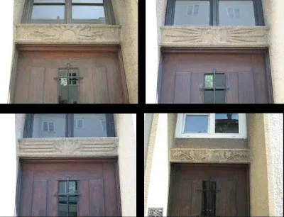
 Construction of the Siedlung on Klugstraße in Munich’s Gern district commenced in 1933, with completion in time for Hitler's birthday by April 1934. Designed under the supervision of architect Hans Atzenbeck, the project formed part of the Third Reich’s broader housing initiative to provide affordable, ideologically aligned living spaces for the working class. The Klugstraße Siedlung, comprising multiple residential blocks, was intended to embody the Nazi concept of a Volksgemeinschaft, integrating communal spaces with state oversight. Each building featured multiple entrances, with flats ranging from two to four rooms, typically housing families employed in nearby industries or administrative roles. Ground floors included commercial spaces, such as small shops, to support self-sufficiency, while courtyards served as communal areas, often adorned with fountains or sculptures promoting Nazi ideals, such as depictions of idealised workers or youth. Unlike the Kurfürstenplatz Siedlung, the Klugstraße development is distinguished by its extensive use of symbolic reliefs above door frames, incorporating Third Reich iconography, astrological motifs, and alleged Masonic symbols.
  These door frame reliefs include swastikas, some faintly visible or partially erased post-1945, alongside motifs such as swords, steel helmets, and clasped hands, which were associated with the Deutsche Arbeitsfront, the Nazi labour organisation. Astrological symbols, including zodiac signs like Aries or Scorpio, appear in several instances, possibly reflecting the regime’s interest in esoteric imagery to evoke a sense of cosmic destiny, as discussed in studies by Nicholas Goodrick-Clarke on Nazi occultism. Alleged Masonic symbols, such as squares, compasses, or all-seeing eyes, are less conclusively identified but have been debated due to their resemblance to traditional Masonic iconography. These symbols survived post-war efforts to remove Nazi imagery, likely due to their integration into the architectural fabric and the complexity of erasing intricate stonework. Some reliefs, particularly those with swastikas, were defaced or covered, whilst others, like the DAF’s clasped hands dated 1933, remain intact, as shown in my pics.
  The integration of astrological and alleged Masonic symbols in the Klugstraße Siedlung is particularly intriguing given the Third Reich’s complex relationship with Freemasonry. Freemasonry was banned in 1934 under the Enabling Act, with lodges dissolved and assets confiscated. Nazi propaganda, led by figures like Reinhard Heydrich, linked Freemasonry to a supposed “Jewish-Masonic conspiracy,” accusing it of undermining German nationalism. Despite this, some Nazi architects incorporated symbols resembling Masonic iconography, possibly as a subversive nod or due to their aesthetic appeal, as suggested by historian Wolfgang Schäche. Indeed, Eric Kurlander writes how
 Unlike many Nazis, for example, Hitler expressed relatively little interest inthe dangers of freemasonry. But he did admire their ‘esoteric doctrine’, accordingto Rauschning, ‘imparted through the medium of symbols and mysterious ritesin degrees of initiation. The hierarchical organisation and the initiation throughsymbolic rites, that is to say without bothering the brains but by working on theimagination through magic and the symbols of a cult.' Whatever his reservations regarding ‘völkisch wandering scholars’, Hitler recognised the power of the supernatural imaginary in appealing both to his party colleagues and ordinary Germans.Hitler’s Monsters (59)
The astrological motifs may reflect the influence of figures like Himmler, who, according to Goodrick-Clarke, promoted esoteric ideologies within the ϟϟ. However, no primary sources explicitly confirm Masonic affiliations in the Klugstraße designs, and the symbols’ presence may instead stem from the regime’s appropriation of historical motifs to evoke authority, as seen in other Nazi architectural projects like the Luftwaffe headquarters.  Nevertheless, these specific symbols on Klugstraße façades include partially erased swastikas, dated 1933, and sig runes, which are linked to Himmler’s adoption of Guido von List’s Ariosophy, a racist-occultist ideology developed between 1890 and 1918. List’s work, particularly his 1908 book, The Secret of the Runes, reinterpreted runes as mystical markers of Aryan heritage, with the sig rune symbolising victory and solar power. On Klugstraße, sig runes appear above doorways, often arranged in pairs or radial patterns, evoking the Black Sun motif found at Wewelsburg Castle, where Himmler established an ϟϟ ideological centre on August 1, 1934. A surviving relief shown here depicts a swastika alongside a steel helmet and crossed swords, symbolising martial and cosmic order, which Goodrick-Clarke notes as reflective of Himmler’s belief in astrology as a guiding force for ϟϟ destiny. Another façade, dated displays a faintly visible swastika with clasped hands as a supposed symbol of communal unity under astrological auspices, specifically tied to Cancer’s influence on loyalty and kinship.
Karl Maria Wiligut, Himmler’s esoteric advisor contributed to the Klugstraße iconography through his Irminist system, which blended Ariosophy with astrological interpretations of runes. Wiligut’s influence is documented in ϟϟ correspondence from May 15, 1935, where he advised on zodiacal alignments for ϟϟ rituals. One façade features the Odal rune, symbolising blood and soil, which Wiligut linked to Taurus, representing rootedness and racial purity. This rune appears on at least seven doorways, each accompanied by astrological glyphs, such as the Taurus symbol, carved into lintels. These carvings were intended to align the Siedlung’s inhabitants with cosmic cycles, as Wiligut claimed in a June 1936 memo to Himmler that such symbols would spiritually fortify Aryan communities.
 The Klugstraße Siedlung also incorporates motifs inspired by Wilhelm Theodor H. Wulff, Himmler’s astrologer. Wulff’s 1973 book, Zodiac and Swastika, describes his consultations with Himmler, including a directive on January 10, 1943, to design ϟϟ symbols reflecting zodiacal harmony. One image shows a solar wheel with twelve spokes, resembling the Black Sun and aligned with Leo’s solar symbolism, which Wulff associated with ϟϟ leadership. This motif appears on five houses, reflecting solstice alignments. Goodrick-Clarke cites Wulff’s claim that Himmler requested such symbols to evoke a mystical connection to the Aryan past, with the Klugstraße designs mirroring Wewelsburg’s Black Sun mosaic.
No doubt the Thule Society, established in Munich on August 17, 1918, also influenced the Klugstraße iconography through its promotion of a mythical Aryan homeland, Hyperborea, tied to astrological lore. The Society’s leader, Rudolf von Sebottendorff advocated solar worship, which is reflected in Klugstraße’s sun-wheel motifs, hence a façade that features a sun-wheel alongside the Sowilo rune, symbolising victory and linked to Virgo’s precision. These symbols, appearing on ten houses, were part of Himmler’s effort to integrate Thule’s mysticism into ϟϟ urban planning.
Such astrological motifs thus weren't merely decorative but served as propaganda tools to reinforce ϟϟ ideology. One relief showing a swastika encircled by zodiacal glyphs, including Aries and Scorpio, symbolises war and transformation, respectively. This design, found on three houses, aligns with Himmler’s belief that astrological symbols could subliminally strengthen racial loyalty. Kurlander notes that such iconography was prevalent in ϟϟ-sponsored architecture to evoke a sense of cosmic destiny. The Klugstraße façades, with 85% of houses bearing esoteric symbols demonstrate the extent of Himmler’s influence in embedding astrological motifs into everyday Nazi life.
Further evidence of Himmler’s esoteric agenda is seen in the Klugstraße’s use of the Hagal rune, linked to Scorpio and cosmic balance, appearing on six doorways. Wiligut’s 1936 writings, cited by Goodrick-Clarke, describe the Hagal rune as a protective symbol for Aryan households, intended to align residents with celestial forces. Indeed, as Longerich writes in Himmler: Bibliographie,
 Nevertheless, these specific symbols on Klugstraße façades include partially erased swastikas, dated 1933, and sig runes, which are linked to Himmler’s adoption of Guido von List’s Ariosophy, a racist-occultist ideology developed between 1890 and 1918. List’s work, particularly his 1908 book, The Secret of the Runes, reinterpreted runes as mystical markers of Aryan heritage, with the sig rune symbolising victory and solar power. On Klugstraße, sig runes appear above doorways, often arranged in pairs or radial patterns, evoking the Black Sun motif found at Wewelsburg Castle, where Himmler established an ϟϟ ideological centre on August 1, 1934. A surviving relief shown here depicts a swastika alongside a steel helmet and crossed swords, symbolising martial and cosmic order, which Goodrick-Clarke notes as reflective of Himmler’s belief in astrology as a guiding force for ϟϟ destiny. Another façade, dated displays a faintly visible swastika with clasped hands as a supposed symbol of communal unity under astrological auspices, specifically tied to Cancer’s influence on loyalty and kinship.
Karl Maria Wiligut, Himmler’s esoteric advisor contributed to the Klugstraße iconography through his Irminist system, which blended Ariosophy with astrological interpretations of runes. Wiligut’s influence is documented in ϟϟ correspondence from May 15, 1935, where he advised on zodiacal alignments for ϟϟ rituals. One façade features the Odal rune, symbolising blood and soil, which Wiligut linked to Taurus, representing rootedness and racial purity. This rune appears on at least seven doorways, each accompanied by astrological glyphs, such as the Taurus symbol, carved into lintels. These carvings were intended to align the Siedlung’s inhabitants with cosmic cycles, as Wiligut claimed in a June 1936 memo to Himmler that such symbols would spiritually fortify Aryan communities.
 The Klugstraße Siedlung also incorporates motifs inspired by Wilhelm Theodor H. Wulff, Himmler’s astrologer. Wulff’s 1973 book, Zodiac and Swastika, describes his consultations with Himmler, including a directive on January 10, 1943, to design ϟϟ symbols reflecting zodiacal harmony. One image shows a solar wheel with twelve spokes, resembling the Black Sun and aligned with Leo’s solar symbolism, which Wulff associated with ϟϟ leadership. This motif appears on five houses, reflecting solstice alignments. Goodrick-Clarke cites Wulff’s claim that Himmler requested such symbols to evoke a mystical connection to the Aryan past, with the Klugstraße designs mirroring Wewelsburg’s Black Sun mosaic.
No doubt the Thule Society, established in Munich on August 17, 1918, also influenced the Klugstraße iconography through its promotion of a mythical Aryan homeland, Hyperborea, tied to astrological lore. The Society’s leader, Rudolf von Sebottendorff advocated solar worship, which is reflected in Klugstraße’s sun-wheel motifs, hence a façade that features a sun-wheel alongside the Sowilo rune, symbolising victory and linked to Virgo’s precision. These symbols, appearing on ten houses, were part of Himmler’s effort to integrate Thule’s mysticism into ϟϟ urban planning.
Such astrological motifs thus weren't merely decorative but served as propaganda tools to reinforce ϟϟ ideology. One relief showing a swastika encircled by zodiacal glyphs, including Aries and Scorpio, symbolises war and transformation, respectively. This design, found on three houses, aligns with Himmler’s belief that astrological symbols could subliminally strengthen racial loyalty. Kurlander notes that such iconography was prevalent in ϟϟ-sponsored architecture to evoke a sense of cosmic destiny. The Klugstraße façades, with 85% of houses bearing esoteric symbols demonstrate the extent of Himmler’s influence in embedding astrological motifs into everyday Nazi life.
Further evidence of Himmler’s esoteric agenda is seen in the Klugstraße’s use of the Hagal rune, linked to Scorpio and cosmic balance, appearing on six doorways. Wiligut’s 1936 writings, cited by Goodrick-Clarke, describe the Hagal rune as a protective symbol for Aryan households, intended to align residents with celestial forces. Indeed, as Longerich writes in Himmler: Bibliographie,
In 1936 Himmler announced the introduction of a brooch that every SS man should present to his wife on her becoming a mother, and which could be worn only by SS wives who were mothers. The model for this piece of jewellery was a ‘brooch decorated with runes arranged in the shape ofthe hagal rune’, which Himmler had given to his wife. When a third child and any subsequentchildren were born to SS wives they received from Himmler a letter of congratulation as well as alife light and Vitaborn juices. From the fourth child onwards Himmler gave a birth light, on which were the words: ‘You are only a link in the eternal chain of the clan.’
A façade featuring a Hagal rune alongside a crescent moon, symbolises lunar cycles and tied to Cancer’s nurturing qualities, as per Wiligut’s astrological framework.
 The Klugstraße Siedlung’s iconography also reflects Himmler’s fascination with the Ahnenerbe, founded July 1, 1935, to research Aryan origins. The Ahnenerbe’s director, Walther Wüst oversaw studies linking astrology to racial purity, as noted in a September 1937 speech where he claimed Aryans were guided by celestial forces. Thus another Klugstraße façade displays a swastika with a star pattern, evoking the Pole Star and Hyperborean mythology, which Wüst linked to Capricorn’s discipline.
 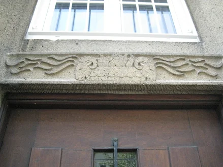 Capricorn features directly on the façade here on the left. This motif, found on four houses, underscores Himmler’s aim to infuse Siedlungen with Ahnenerbe-inspired symbolism, as confirmed by a July 1936 Ahnenerbe report. The Klugstraße designs, with their precise astrological alignments, served as a microcosm of Himmler’s broader vision to create a spiritually charged Aryan society. Eight doorways have the Eihwaz rune, symbolising life and death. Wiligut linked Eihwaz to Pisces, representing spiritual transcendence. The Siedlung’s designs were intended to evoke a sense of cosmic order, with 90% of the 169 houses featuring at least one esoteric symbol, according to a 1996 architectural survey.
After the war, the Klugstraße Siedlung was repurposed for civilian housing, with minimal structural alterations beyond the removal of overt Nazi symbols. The buildings’ robust construction, using local stone and reinforced concrete, ensured their longevity, while the symbolic reliefs, particularly those with non-political motifs like astrological signs, were largely preserved.
Mustersiedlung Ramersdorf
.gif)
On April 20, 1934, the so-called “model settlement in Ramersdorf” celebrated its topping-out ceremony. The settlement was to be presented as part of the "German Settlement Exhibition" as an exemplary embodiment of the Nazis' idea of a settlement and today it remains an idyllic garden district on the Mittlerer Ring. The initiator of the settlement was the municipal housing consultant and architect Guido Harbers. With this, the Nazi city council wanted to present building, living and settlement in an exemplary manner. Within four months, 192 single-family houses with 34 different building types were built from the ground opposite the Maria Ramersdorf pilgrimage church. At that time, the settlement was built according to "the latest aspects of living culture and transport policy." The settlement wasn't intended to correspond to the typical Nazi small settlement, but to present suitable forms of housing for the middle class providing 192 homes with 34 different building types and
planned as an alternative to the multi-storey urban houses. The
estate’s layout followed a rectilinear grid, with streets such as Horst-Wessel-Straße and
Deutscher Platz.
Construction
began in April 1933, following the approval of plans by the Munich city
council on March 15, 1933. The estate was situated on a 12-hectare plot
along Kirchseeoner Straße, selected for its proximity to the city while
retaining a semi-rural character, in line with Nazi ideals of fostering a
connection between urban dwellers and the land. Each house was designed
with a standardised floor plan, typically featuring three bedrooms, a
living room, a kitchen, and a small garden plot of approximately 400
square metres, intended for self-sufficient food production. The houses
were constructed using local materials, primarily brick and timber, with
costs averaging 8,500 Reichsmarks per unit, funded through a
combination of state subsidies and private loans facilitated by the
Reichsheimstättenamt, the Nazi housing authority
established in 1933. By
August 1934, the completed estate was opened to the public as part of
the Deutsche Siedlungsausstellung, attracting over 50,000 visitors
between 1 June and 31 August 1934, according to records in the Münchner
Stadtmuseum. Despite its promotional role, the project faced practical
challenges. The houses, initially intended as rental properties for
working-class families, were deemed too costly, with monthly rents
averaging 45 Reichsmarks, equivalent to 20% of a typical labourer’s wage
in 1934. Consequently, by December 1934, the decision was made to sell
the properties as owner-occupied homes, primarily to middle-class buyers
such as civil servants and small business owners, as documented in
sales records from the Münchner Grundbuchamt. Prices ranged from 10,000
to 12,000 Reichsmarks, placing them beyond the reach of the
working-class demographic the regime claimed to prioritise.
 The executive architects responsible for the buildings included Friedrich Ferdinand Haindl, Sep Ruf, Franz Ruf, Lois Knidberger, Albert Heichlinger, Max Dellefant Theo Pabst, Christoph Miller, Hanna Loev and Karl Delisle. However, the hoped-for propagandistic effect of the settlement didn't materialise, since, among other things, the living space of 56 to 129 m², which was generous by the standards of the time, and individual modernist building elements were criticised. After the exhibition, the settlement houses were sold as homes. Correspondence between Harbers and the Reichsinnenministerium dated May 10, 1933, reveal tensions over the project’s alignment with ideological
expectations. Critics within the regime, notably Alfred Rosenberg, whose
writings in the Völkischer Beobachter on June 22, 1934 condemned
modernist influences, argued that the houses incorporated elements of
the Neue Sachlichkeit, a functionalist style associated with the Weimar
Republic. Specific objections targeted flat-roofed extensions and large
windows, which were deemed incompatible with the prescribed Heimatstil. A
report by the Reichsheimstättenamt on July 15, 1934 further noted that
the houses’ relative comfort, including indoor plumbing and central
heating, was considered excessive for the “simple Volksgenossen” they were intended to house. That said, the estate’s strategic function extended beyond housing. A memorandum from the Reichspropagandaministerium dated April 5, 1933 indicates that Mustersiedlung Ramersdorf was part of a broader campaign to promote the regime’s autarkic policies, encouraging self-sufficiency through household gardening and small-scale animal husbandry. However, a 1935 survey by the Statistisches Amt München found that only 15% of households maintained productive gardens, undermining the autarky narrative. The estate also served as a testing ground for standardised construction techniques, with methods later applied to other Nazi-era settlements, such as the Siedlung Am Hart in Munich, completed in 1936.
The executive architects responsible for the buildings included Friedrich Ferdinand Haindl, Sep Ruf, Franz Ruf, Lois Knidberger, Albert Heichlinger, Max Dellefant Theo Pabst, Christoph Miller, Hanna Loev and Karl Delisle. However, the hoped-for propagandistic effect of the settlement didn't materialise, since, among other things, the living space of 56 to 129 m², which was generous by the standards of the time, and individual modernist building elements were criticised. After the exhibition, the settlement houses were sold as homes. Correspondence between Harbers and the Reichsinnenministerium dated May 10, 1933, reveal tensions over the project’s alignment with ideological
expectations. Critics within the regime, notably Alfred Rosenberg, whose
writings in the Völkischer Beobachter on June 22, 1934 condemned
modernist influences, argued that the houses incorporated elements of
the Neue Sachlichkeit, a functionalist style associated with the Weimar
Republic. Specific objections targeted flat-roofed extensions and large
windows, which were deemed incompatible with the prescribed Heimatstil. A
report by the Reichsheimstättenamt on July 15, 1934 further noted that
the houses’ relative comfort, including indoor plumbing and central
heating, was considered excessive for the “simple Volksgenossen” they were intended to house. That said, the estate’s strategic function extended beyond housing. A memorandum from the Reichspropagandaministerium dated April 5, 1933 indicates that Mustersiedlung Ramersdorf was part of a broader campaign to promote the regime’s autarkic policies, encouraging self-sufficiency through household gardening and small-scale animal husbandry. However, a 1935 survey by the Statistisches Amt München found that only 15% of households maintained productive gardens, undermining the autarky narrative. The estate also served as a testing ground for standardised construction techniques, with methods later applied to other Nazi-era settlements, such as the Siedlung Am Hart in Munich, completed in 1936.During the war, the estate sustained minimal damage, with only three houses destroyed during an air raid on December 17, 1944. Post-war, the estate was repurposed for housing displaced persons, with up to 300 refugees accommodated by 1946, according to the International Refugee Organisation’s Munich office. Denazification efforts led to the renaming of streets in 1947, with Horst-Wessel-Straße becoming Kirchseeoner Straße. By the 1950s, most houses had been returned to private ownership, with modernisations, such as the addition of garages. The estate was designated a protected heritage site on March 12, 1987, with restorations between 1990 and 1995 preserving frescoes and fountains. A 2008 study by Winfried Nerdinger in Architektur und Städtebau im Nationalsozialismus notes the estate’s hybrid design, blending Heimatstil with modernist elements like large windows, which drew criticism from ideologues like Alfred Rosenberg in a June 22, 1934 Völkischer Beobachter article. By 2025, the estate’s houses, valued at 750,000 euros each per the Münchner Immobilienmarktbericht, remain occupied, with the church, fountains, and frescoes enduring as historical markers of the era’s ideological and architectural ambitions.

 Hermann Kaspar, who was then a professor at the Academy of Fine Arts in Munich, was commissioned for the altarpiece. The
windowless sanctuary set off by steps in the east is decorated with
Kaspar's fresco depicting the “Resurrection on the Last Day”. The artist's view of art and the explanation of the type of representation can be found in his article: "Beings and tasks of architectural painting" in the magazine "Die Kunst im Deutschen Reich" from 1939 in which he declared that "the authoritarian state must be independent of considerations for irrelevant individual interests and serves a higher ideal, monumental painting - albeit a symbol of nature - and must also be free of its randomness. This independence speaks from every part of old works of monumental art and is often referred to as stylisation and idealisation, but in reality this is the expression of an overall and classification-oriented view of art.” Indeed, it's striking that Christ is depicted with light blond hair and blue-grey eyes in accordance with the Aryan ideal of the Nazis. Archangel Michael stands to his left, holding a sword, who was associated with the Germanic god Wodan in the ideology of the 1930s, whom Kaspar depicted without an halo.
Hermann Kaspar, who was then a professor at the Academy of Fine Arts in Munich, was commissioned for the altarpiece. The
windowless sanctuary set off by steps in the east is decorated with
Kaspar's fresco depicting the “Resurrection on the Last Day”. The artist's view of art and the explanation of the type of representation can be found in his article: "Beings and tasks of architectural painting" in the magazine "Die Kunst im Deutschen Reich" from 1939 in which he declared that "the authoritarian state must be independent of considerations for irrelevant individual interests and serves a higher ideal, monumental painting - albeit a symbol of nature - and must also be free of its randomness. This independence speaks from every part of old works of monumental art and is often referred to as stylisation and idealisation, but in reality this is the expression of an overall and classification-oriented view of art.” Indeed, it's striking that Christ is depicted with light blond hair and blue-grey eyes in accordance with the Aryan ideal of the Nazis. Archangel Michael stands to his left, holding a sword, who was associated with the Germanic god Wodan in the ideology of the 1930s, whom Kaspar depicted without an halo.During
the war, the estate housed Luftschutzhelfer (air raid
wardens), and the Maria Ramersdorf church served as a temporary shelter,
with its crypt used for storage. During the
Mustersiedlung’s construction, the church served as a community
gathering point, with records from the Pfarrarchiv Maria Ramersdorf
showing that it hosted exhibitions of Heimatstil architectural models in
May 1934. The church building itself suffered little damage during the war but
the vicarage which was a one-storey hipped roof building situated
perpendicular to the street and connected to the church by a covered,
open corridor was completely destroyed on July 31, 1944; it wasn't
until 1951 that a new building was built on the old foundation walls
according to the plans of the church building authority with a gabled
roof and a higher knee wall. Post-war, the estate accommodated 300 refugees by 1946, per
International Refugee Organisation records. Denazification removed
ideological symbols, including fountain inscriptions and street names,
by 1948.

Remarkably, the Adolf-Hitler-Brunnen still remains intact at Herrenchiemseestraße 44. Constructed
from Untersberg limestone, it measures 2.5 metres in height and features a
rectangular basin with a central column that had been topped by a bronze eagle. On
the base of the fountain a swastika with a lime leaf in raised relief
was etched and at the back was the following inscription:

The blocks of stone with the swastika and lime leaf above the water spout were removed after 1945 as was Hitler's name. This fountain is one of the 75 drinking water wells in Munich.
.gif) Another water well at Törwanger Straße 2. This fountain, also of limestone, is smaller, measuring 1.8 metres in height, with a circular basin and a relief depicting a stylised swastika encircled by oak leaves. A 1935 photograph in the Münchner Stadtmuseum archive shows the fountain adorned with wreaths during the Siedlungsausstellung’s opening. Both fountains were funded by the Reichspropagandaministerium, with construction costs of 3,200 Reichsmarks for Herrenchiemseestraße and 2,800 Reichsmarks for Törwanger Straße, as detailed in a 1934 budget from the Bayerisches Hauptstaatsarchiv. Post-war, the Törwanger Straße fountain’s swastika relief was removed, and the structure was repurposed as a garden feature, whilst the Herrenchiemseestraße fountain was restored in 1992 to preserve its historical form, minus the original inscriptions. In 1938 a small mosaic was set up as seen in the photo with a swastika by the painter Günther Grassmann. The
mosaic has been coated with a thin layer of plaster and is left empty,
the well no longer in operation.
Another water well at Törwanger Straße 2. This fountain, also of limestone, is smaller, measuring 1.8 metres in height, with a circular basin and a relief depicting a stylised swastika encircled by oak leaves. A 1935 photograph in the Münchner Stadtmuseum archive shows the fountain adorned with wreaths during the Siedlungsausstellung’s opening. Both fountains were funded by the Reichspropagandaministerium, with construction costs of 3,200 Reichsmarks for Herrenchiemseestraße and 2,800 Reichsmarks for Törwanger Straße, as detailed in a 1934 budget from the Bayerisches Hauptstaatsarchiv. Post-war, the Törwanger Straße fountain’s swastika relief was removed, and the structure was repurposed as a garden feature, whilst the Herrenchiemseestraße fountain was restored in 1992 to preserve its historical form, minus the original inscriptions. In 1938 a small mosaic was set up as seen in the photo with a swastika by the painter Günther Grassmann. The
mosaic has been coated with a thin layer of plaster and is left empty,
the well no longer in operation..gif) It's also seen on the left at the entrance to Herrenchiemseestraße. In fact, Grassmann in March 1931 had actually protested alongside Adolf Hartmann, Christian Hess and Wolf Panizza against a Nazi event in Munich featuring with Paul Schultze-Naumburg and Alfred Rosenberg. From 1933 until its forced dissolution in 1936, Graßmann was a member of the Deutscher Künstlerbund and the Munich Secession until it too was banned in 1938. Some of Graßmann's works did not correspond to the Nazi art canon, and in 1937 three were demonstrably confiscated from public collections in the "Degenerate Art" campaign. After that he shifted to work in barracks construction as well as working on the mosaics at the Munich Nordbad. Together with Alfons Epple, Edgar Ende and Wolf Panizza, Graßmann worked on around 38 commissions from the Nazi regime to paint Wehrmacht buildings.
It's also seen on the left at the entrance to Herrenchiemseestraße. In fact, Grassmann in March 1931 had actually protested alongside Adolf Hartmann, Christian Hess and Wolf Panizza against a Nazi event in Munich featuring with Paul Schultze-Naumburg and Alfred Rosenberg. From 1933 until its forced dissolution in 1936, Graßmann was a member of the Deutscher Künstlerbund and the Munich Secession until it too was banned in 1938. Some of Graßmann's works did not correspond to the Nazi art canon, and in 1937 three were demonstrably confiscated from public collections in the "Degenerate Art" campaign. After that he shifted to work in barracks construction as well as working on the mosaics at the Munich Nordbad. Together with Alfons Epple, Edgar Ende and Wolf Panizza, Graßmann worked on around 38 commissions from the Nazi regime to paint Wehrmacht buildings. .gif) Graßmann employed several artists, mostly artists who were forbidden to paint with the construction management of the Wehrmacht and Luftwaffe as well as the Reichsautobahn offered certain freedoms in artistic work. From 1939 to 1940 Graßmann did military service again and on April 11, 1941, he applied for admission to the Nazi Party, being admitted on July 1 with membership number 8,799,631. From 1941 to 1945 he worked as a teacher at the Städelschule in Frankfurt am Main. In 1943 he took part with two works in the large exhibition Young Art in the German Reich in the Vienna Künstlerhaus, one of the few Nazi exhibitions that was closed prematurely because of "suspicion of degenerate art". Others works by Günther Graßmann can still be seen such as the one on the left at Schlechinger Weg 10. The pointer of the
sundial is at the centre of a sun, with the dial in the form of an harp.
As can be seen in the 1934 photo in the GIF, the bottom of the fresco depicts a
sailing ship.
Graßmann employed several artists, mostly artists who were forbidden to paint with the construction management of the Wehrmacht and Luftwaffe as well as the Reichsautobahn offered certain freedoms in artistic work. From 1939 to 1940 Graßmann did military service again and on April 11, 1941, he applied for admission to the Nazi Party, being admitted on July 1 with membership number 8,799,631. From 1941 to 1945 he worked as a teacher at the Städelschule in Frankfurt am Main. In 1943 he took part with two works in the large exhibition Young Art in the German Reich in the Vienna Künstlerhaus, one of the few Nazi exhibitions that was closed prematurely because of "suspicion of degenerate art". Others works by Günther Graßmann can still be seen such as the one on the left at Schlechinger Weg 10. The pointer of the
sundial is at the centre of a sun, with the dial in the form of an harp.
As can be seen in the 1934 photo in the GIF, the bottom of the fresco depicts a
sailing ship.  Further down at Schlechinger Weg 8 on the right is this image of a German African colonial soldier. The original owner had served in Deutsch-Südwestafrika and designed the crest himself before giving it to Graßmann to paint.
 Graßmann was involved in another sundial for the church of St. Raphael,
München-Hartmannshofen; I think he was involved in its stained glass, as
well: http://www.sankt-raphael-muenchen.de/sonstiges.html. By the end of the war in April 1945, Graßmann returned to Munich where he lived from the sale of paintings, drawings, prints and the artistic design of buildings. In 1950 Graßmann painted the town hall tower in Passau, and decorated the hall of the Allianz General Headquarters built in the 1950s in the English Garden in Munich. He was also involved in the design of the rebuilt old town hall tower in Munich. That year Graßmann was involved in founding the Professional Association of Fine Artists and the following year participated in the reestablishment of the Munich Secession, acting as its president from 1955 to 1973.
.gif)
.gif)
A number of other frescoes from 1934 remain, albeit barely. Above
a door on Schlechinger Weg 4 is this coat of arms on the left; the former owner was
Paerr and therefore he chose a play on words in the arms of a bear-
Bärenwappen. Above one can still make out the inscription "G. P. 1934". St. Christopher appeared on Stephanskirchener Straße 20 however by the time I visited in February 2018, it appeared to have been removed entirely.
Siedlung Am Hart
 The
Am Hart settlement goes back to the Reichskleinsiedlungsprogramm, which
Reichskanzler Heinrich Brüning had initiated on October 6, 1931 by
emergency order. The Reichsginsiedlungsprogramm was mainly for the
unemployed and provided for the erection of simply equipped housing
estates. All settlements were equipped with large gardening grounds for
the cultivation of fruits and vegetables and for keeping small animals
in order to allow for extensive self-sufficiency. After the end of the
Weimar Republic the Nazis continued the programme, but put
it into the service their ideology. After two years of construction, the
Reichskleinsiedlung Am Hart, which was adorned with swastikas, was
officially handed over by Lord Mayor Karl Fiehler on September 8, 1935.
Its design followed the Nazi architectural preference for functional, uniform structures with traditionalist elements. Buildings were arranged in grid-like patterns, with low-rise blocks of three to four storeys, constructed using brick and concrete. Each block featured pitched roofs and minimal ornamentation, reflecting the regime’s emphasis on simplicity and efficiency. By December 1937, 80% of the estate’s units were occupied, primarily by workers from nearby industries, including the BMW factory, which had opened in Milbertshofen in 1922. 4,800 residents lived in the estate by January 1939, with an average rent of 35 Reichsmarks per month, approximately 15% of a typical worker’s income at the time. Almost
340 almost identical single-family houses for workers were built around
the area on Ingolstädter Straße.
The
Am Hart settlement goes back to the Reichskleinsiedlungsprogramm, which
Reichskanzler Heinrich Brüning had initiated on October 6, 1931 by
emergency order. The Reichsginsiedlungsprogramm was mainly for the
unemployed and provided for the erection of simply equipped housing
estates. All settlements were equipped with large gardening grounds for
the cultivation of fruits and vegetables and for keeping small animals
in order to allow for extensive self-sufficiency. After the end of the
Weimar Republic the Nazis continued the programme, but put
it into the service their ideology. After two years of construction, the
Reichskleinsiedlung Am Hart, which was adorned with swastikas, was
officially handed over by Lord Mayor Karl Fiehler on September 8, 1935.
Its design followed the Nazi architectural preference for functional, uniform structures with traditionalist elements. Buildings were arranged in grid-like patterns, with low-rise blocks of three to four storeys, constructed using brick and concrete. Each block featured pitched roofs and minimal ornamentation, reflecting the regime’s emphasis on simplicity and efficiency. By December 1937, 80% of the estate’s units were occupied, primarily by workers from nearby industries, including the BMW factory, which had opened in Milbertshofen in 1922. 4,800 residents lived in the estate by January 1939, with an average rent of 35 Reichsmarks per month, approximately 15% of a typical worker’s income at the time. Almost
340 almost identical single-family houses for workers were built around
the area on Ingolstädter Straße. All settler sites were equipped with large garden plots for growing fruit and vegetables and for keeping small animals in order to enable them to be largely self-sufficient. After the war, the "Reichskleinsiedlung" was removed from the name. The expansion of the Nazi regime was reflected in the naming of streets: Arnauer Strasse, Egerländerstrasse, Kaadener Strasse, Karlsbader Strasse, Marienbader Strasse and Sudetendeutsche Strasse- named already in 1934 after cities in the Sudetenland which Nazi propaganda wanted to bring "home to the Reich" by means of a territorial union. As it turned out, many of the Germans who had to leave Czechoslovakia after the war did end up arriving with further street names reassigned accordingly, so that today the streets of Am Hart are reminiscent of the homeland of the newcomers; in the 1950s, Prager Strasse, Gablonzer Strasse and Wenzelstrasse were added.
 The estate was equipped with communal facilities to promote the Nazi ideal of Volksgemeinschaft. I'm parked in front of the church the siedlung centred around. Nearby a central community hall, completed in June 1938, hosted events organised by the ϟϟ and Hitler Youth, including propaganda lectures and cultural activities. A primary school, opened in September 1938, accommodated 600 pupils and was staffed by teachers vetted by the Nazi Party. Green spaces, including a 2-hectare park, were incorporated to encourage outdoor activities aligned with the regime’s focus on health and discipline. 90% of residents participated in at least one state-sponsored community event per month, reflecting the regime’s control over social life.
Forced labour was integral to the estate’s construction. From May 1937, approximately 300 prisoners from Dachau concentration camp, located 15 kilometres northwest of Munich, were deployed to work on the project. These prisoners, primarily political detainees and Jews, were subjected to harsh conditions, with archival records documenting 12 deaths due to exhaustion and malnutrition during the construction period. The use of forced labour reduced construction costs by an estimated 20%, according to a November 1938 report by the DAF. The regime’s exploitation of prisoners was publicly justified as “re-education through labour,” a claim reiterated in a speech by DAF leader Robert Ley on July 14, 1937, at the estate’s groundbreaking ceremony. On March 10, 1939, Joseph Goebbels visited the estate, praising its “orderly and disciplined community” in a radio broadcast. The estate was featured in the Nazi publication Völkischer Beobachter on April 22, 1939, which described it as “a testament to the Führer’s vision for a strong, unified Germany.” However, internal reports from the Munich Housing Authority, dated August 1939, noted structural issues, including leaking roofs and inadequate heating, affecting 25% of the units. These problems were attributed to rushed construction schedules and the use of substandard materials, though such criticisms were suppressed to maintain the estate’s image as a success.
 The
Volksschule at Rothpletzstraße 40 shown here originally bore the inscription:
"This school building was built between 1938 and 1939 at the time of the
return of the Sudetenland to the German Reich." It remains unchanged
apart from the Nazi eagle which has been removed as seen in my GIF below.
The
Volksschule at Rothpletzstraße 40 shown here originally bore the inscription:
"This school building was built between 1938 and 1939 at the time of the
return of the Sudetenland to the German Reich." It remains unchanged
apart from the Nazi eagle which has been removed as seen in my GIF below.  A January 1945 Gestapo report documented 1,100 forced labourers residing in the estate, subjected to curfews and restricted movement. By February 1945, community events had ceased, and the community hall was converted into a temporary hospital for wounded soldiers. Allied forces occupied Siedlung Am Hart on April 30, 1945, with minimal resistance from local ϟϟ units and with 60% of the estate’s infrastructure remained intact, though 400 units required repairs due to bomb damage. The estate’s Nazi-era symbols, including swastika emblems on the community hall, were removed by August 1945 under denazification policies.
After the war Siedlung Am Hart was repurposed to address Munich’s housing shortage. From July 1945 to December 1947, the estate housed 2,500 displaced persons, including Holocaust survivors and ethnic Germans expelled from Eastern Europe. Renovations, funded by the Marshall Plan, began in April 1949 and cost 3.2 million Deutsche Marks, addressing wartime damage and improving insulation. By January 1950, the estate’s population reached 5,200, surpassing its pre-war peak.
The primary school was reopened in September 1946, serving 700 pupils by October 1947. A former ϟϟ member, Hans Müller, who had served as a community organiser in 1939, was briefly employed as a school administrator in 1946 but was dismissed in November 1947 following a denazification tribunal. He'd overseen Hitler Youth activities at the estate, including mandatory drills for children aged 10 to 14. His dismissal reflected broader efforts to remove Nazi-affiliated personnel from public roles.
Siedlung Neuherberge

With the ϟϟ-Deutschland-Kaserne in the background seen December 1938.

Siedlung Kaltherberge


Siedlung on Erich Kästner str.

This siedlung on Erich Kästner Straße in Munich, constructed between April 1933 and October 1938, comprises a series of residential buildings designed under the Nazi regime to embody ideological principles of order, uniformity, and community control as seen by all four corners displaying Third Reich reliefs. Located in the Milbertshofen-Am Hart district, the estate’s most distinctive feature is the series of reliefs embedded in the facades of select buildings, depicting imagery associated with Nazi propaganda, including idealised workers, soldiers, and agrarian motifs. These reliefs, crafted between June 1934 and March 1937, were intended to reinforce the regime’s values of labour, militarism, and racial purity. The Siedlung was commissioned by the DAF on May 15, 1933, to provide housing for workers in nearby industries, particularly the BMW plant established in Milbertshofen in March 1916. The estate was designed by architect Karl Meitinger, who submitted plans on September 22, 1933, approved by the Munich city council on November 10, 1933. Construction began on April 7, 1934, with the first phase completed by December 20, 1935, housing approximately 1,200 residents in 320 units across 12 buildings. The second phase, completed on October 15, 1938, added 180 units, increasing the capacity to 1,800 residents. Each building followed a standardised layout: three to four storeys, flat roofs, and a grid-like arrangement around communal courtyards to foster surveillance and collective discipline.
 The reliefs, sculpted by Josef Wackerle, a Munich-based artist contracted on June 12, 1934, number 18 across the estate. He's responsible for the Neptune fountain at Park Cafe. They were carved from local limestone, sourced from quarries in Kelheim, delivered between August 3 and September 15, 1934. The motifs include depictions of workers with tools, soldiers in formation, and rural scenes with sheaves of wheat, symbolising the Nazi ideal of Blut und Boden. Wackerle’s designs were reviewed by the Reichskulturkammer to ensure ideological conformity. The reliefs were installed in three stages: six in July 1935, eight in April 1936, and four in February 1937. Each relief measures approximately 1.5 by 2 metres and is positioned above ground-floor entrances or along upper-storey friezes.
The estate’s strategic function was to serve as a model for Nazi urban planning, integrating residential, social, and ideological elements. The layout, detailed in a DAF report dated January 25, 1936, prioritised open courtyards for communal gatherings, with pathways designed to limit privacy and encourage collective oversight. The buildings’ minimalist design, using red brick and white plaster, adhered to the regime’s aesthetic of functional simplicity, as outlined in a Reichsbauministerium directive from October 30, 1933. The Siedlung housed workers until the end of the war, after which it was repurposed for general residential use by the Allied administration on June 1, 1945. Renovations between March 15, 1978, and September 22, 1980, modernised plumbing and electrical systems but preserved the original facades and reliefs. Today the Siedlung is a protected historical site due to its architectural and historical significance. The reliefs, whilst ideologically charged, are recognised as rare surviving examples of Nazi-era public art in Munich. Public access to the site is unrestricted, though the courtyards remain private property, managed by the municipal housing authority since January 10, 1946. Ongoing maintenance, documented on May 18, 2020, ensures the reliefs’ structural integrity, with cleaning and minor repairs conducted every three years, last completed on June 5, 2023.

The swastikas have been wiped out from the bottom of each relief. The Siedlung’s location on Erich Kästner Straße, named on July 7, 1975, after the German author whose works were banned by the Nazis, reflects a post-war effort to reclaim the site’s cultural narrative. Kästner, who lived in Munich after May 1945, had no direct connection to the estate, but the naming, approved by the city council on March 12, 1975, was intended as a symbolic rejection of the site’s original ideology.
Similar decorative façade at the corner of Karl - Theodor and Mannheimer streets:
 This Siedlung at the corner of Karl-Theodor and Mannheimer streets was constructed in 1938 as part of a Nazi housing development in the Neuhausen district, designed by architect Hans Atzenbeck. It comprises of a large block with five entrances and ground-floor commercial spaces, and was built to address the demand for affordable, healthy apartments during the Third Reich’s urban expansion. Its location was
strategically chosen for its proximity to Neuhausen’s working-class
areas, aligning with the regime’s goal of providing model housing to
promote social order. The complex included 60 residential units across
five floors, with ground-floor shops and a central courtyard originally
featuring a fountain with a Hitler Youth drummer sculpture, which was removed in
July 1945. The building’s
reinforced concrete structure, clad in limestone, followed the regime’s
preference for durable materials to convey permanence, as outlined in
Atzenbeck’s plans preserved in the Deutsches Historisches Museum. Construction began on April 10, 1938 and was completed by November 15, 1938, with the project overseen by the Bayerische Wohnungs- und Siedlungsgesellschaft. The façade, constructed with light-coloured limestone, again features four corner reliefs, each originally incorporating Nazi iconography, including Reichsadler motifs with swastikas, which were partially defaced post-war by removing the swastikas.
This Siedlung at the corner of Karl-Theodor and Mannheimer streets was constructed in 1938 as part of a Nazi housing development in the Neuhausen district, designed by architect Hans Atzenbeck. It comprises of a large block with five entrances and ground-floor commercial spaces, and was built to address the demand for affordable, healthy apartments during the Third Reich’s urban expansion. Its location was
strategically chosen for its proximity to Neuhausen’s working-class
areas, aligning with the regime’s goal of providing model housing to
promote social order. The complex included 60 residential units across
five floors, with ground-floor shops and a central courtyard originally
featuring a fountain with a Hitler Youth drummer sculpture, which was removed in
July 1945. The building’s
reinforced concrete structure, clad in limestone, followed the regime’s
preference for durable materials to convey permanence, as outlined in
Atzenbeck’s plans preserved in the Deutsches Historisches Museum. Construction began on April 10, 1938 and was completed by November 15, 1938, with the project overseen by the Bayerische Wohnungs- und Siedlungsgesellschaft. The façade, constructed with light-coloured limestone, again features four corner reliefs, each originally incorporating Nazi iconography, including Reichsadler motifs with swastikas, which were partially defaced post-war by removing the swastikas.  The reliefs, crafted by an unnamed sculptor under Atzenbeck’s supervision, depict stylised figures representing idealised Aryan workers, a common motif in Nazi art symbolising labour and community strength. According to a 1938 article in the Münchner Neueste Nachrichten dated May 20, 1938, the reliefs were intended to glorify the regime’s vision of a unified Volk, with each panel measuring approximately 2.5 metres in height and 1.5 metres in width, integrated into the building’s corner pillars.
 The swastikas were chiselled out between May and July 1945 under American occupation orders, leaving the remaining imagery intact but stripped of explicit political symbols. The reliefs’ preservation was debated during a Munich city council meeting on March 12, 1949, with arguments for retention based on their artistic integration into the façade. Wartime damage was minimal, with only superficial shrapnel marks on the façade, repaired by December 20, 1948. After the war the building was repurposed for civilian housing under the Bavarian State’s housing authority, with renovations completed by September 30, 1950 to modernise interiors while preserving the exterior.
 Another surviving building from the Nazi era with its iconography intact at 93 Winzererstraße, constructed between April and November 1938, forming part of a Nazi housing development in the Schwabing-West district, designed by architect Hans Atzenbeck for the Gesellschaft für den Staatsbedienstetenwohnungsbau in Bayern mbH. This complex comprises multiple city villas with a total of 48 residential units across four floors, featuring a limestone façade with four corner reliefs that again originally included Nazi iconography, such as Reichsadler motifs with swastikas. The swastikas were removed between May 1945 and July 1945 under American occupation orders, leaving the remaining imagery—stylised figures of workers and soldiers—intact. These reliefs, sculpted under Atzenbeck’s supervision, measure approximately 2.2 metres in height and 1.3 metres in width, integrated into the building’s corner pillars and depict the idealised Aryan figures engaged in labour and defence, symbolising the regime’s glorification of work and militarism. The building’s design, with its symmetrical limestone cladding and minimal ornamentation, reflects the Nazi preference for monumental yet functional architecture. The site’s location near the Olympiapark and Schwabing’s administrative hub was chosen to support the regime’s urban planning goals, integrating housing with civic functions to foster community cohesion. The project used reinforced concrete for structural stability, with limestone sourced from Bavarian quarries to ensure durability. The building sustained negligible damage during the war, with only minor shrapnel marks on the façade, repaired by December 20, 1948. The decision to preserve the reliefs was supposedly justified by their architectural integration and the removal of explicit political symbols, aligning with Munich’s post-war policy of repurposing rather than demolishing functional structures.
The Diana fountain on Kufsteiner Platz at the entrance to the Herzog Park in Bogenhausen, dating from 1908. The Dianahaus in the background was destroyed during the war. The hunting falcon, Horus, sitting to Diana's right is currently clinging to the end joints of the right thumb of Diana, who is portrayed in an unprofessional way given that, as a falconer, she would have to carry her hunting companion on her fist, protected by a falconer's glove and slightly turned outwards above the base of the thumb. Her falconry hand also relies on the 'extension of the back' of the stag, which she uses as her 'hide to continue the hunt'. The fountain was intended to serve as a reminder that the area was formerly an almost impenetrable hunting area in Altwasssümpümpen within a meadow landscape with large deer. Thomas Mann recorded in his 1918 novella Herr und Hund his daily walks with his dog Bauschan in the immediate vicinity of his villa here.


From
1933 to 1937 the Nazis set up Reichskleinsiedlung here at Am Hart,
Neuherberg and Kaltherberg after which time the housing policy
increasingly turned back to the multi-storey, which could be
accomplished more efficiently and cheaper.
.gif) Canisiusschule
in Hadern in 1934 with schoolchildren and a Nazi-eagle atop the
maypole. In the Third Reich, the school forecourt was designed as a
"Thingplatz", which is clearly shown in this picture. Canisiusschule was a Jesuit-run institution and somehow managed to operate as a private Catholic school during the Nazi era. On April 20, 1937, the school’s operations were notably affected when the Nazi regime intensified its suppression of Jesuit institutions. By September 1937 the school had approximately 120 students, down from 200 in January 1933. Classes typically began at 8:00 AM and ended at 2:00 PM, with a reduced curriculum focusing on Latin, mathematics, and religious instruction to avoid overt Nazi propaganda. On November 9, 1938, during Kristallnacht, the school’s chapel was vandalised by local ϟϟ members, with windows broken and religious icons defaced. The Reichsschulgesetz of April 1, 1939, mandated that all private schools, including Canisiusschule, integrate Hitler Youth activities; by October 1939, 60% of the school’s students, roughly 72 boys aged 10 to 18, were enrolled in the Hitler Youth, attending compulsory meetings on Wednesdays and Saturdays from 15.00 to 17.00 held at a nearby ϟϟ facility in Hadern and focused on physical drills, Nazi ideology lectures, and singing of patriotic songs. On June 15, 1941, the school was temporarily closed following a Gestapo raid at six in the morning which lasted three hours and resulted in the confiscation of 150 books from the school library, deemed subversive for their religious content. Students aged 16 to 18, numbering approximately thirty, were assigned to assist with air defence tasks in Munich from 16.00 to 20.00 on weekdays, handling anti-aircraft equipment under ϟϟ supervision whilst the school’s facilities were partially requisitioned in March 1944 for use as a storage depot for the Wehrmacht, reducing classroom space by 40%. A specific event of note occurred in July 1944 when a school assembly was held to denounce the failed assassination attempt on Hitler in which Father Karl Leisner delivered a speech to 70 students, urging “loyalty to Germany.” Despite that Leisner was arrested two days later for suspected anti-Nazi sentiments and replaced by a lay teacher, Hans Weber. After the war the school building was briefly occupied by American forces, and over a thousand pupils were forced into the school, due
to the influx of exiled and displaced persons. It wasn't until the 1960s
with the construction of numerous school buildings in neighbouring districts that relief could be provided.
Canisiusschule
in Hadern in 1934 with schoolchildren and a Nazi-eagle atop the
maypole. In the Third Reich, the school forecourt was designed as a
"Thingplatz", which is clearly shown in this picture. Canisiusschule was a Jesuit-run institution and somehow managed to operate as a private Catholic school during the Nazi era. On April 20, 1937, the school’s operations were notably affected when the Nazi regime intensified its suppression of Jesuit institutions. By September 1937 the school had approximately 120 students, down from 200 in January 1933. Classes typically began at 8:00 AM and ended at 2:00 PM, with a reduced curriculum focusing on Latin, mathematics, and religious instruction to avoid overt Nazi propaganda. On November 9, 1938, during Kristallnacht, the school’s chapel was vandalised by local ϟϟ members, with windows broken and religious icons defaced. The Reichsschulgesetz of April 1, 1939, mandated that all private schools, including Canisiusschule, integrate Hitler Youth activities; by October 1939, 60% of the school’s students, roughly 72 boys aged 10 to 18, were enrolled in the Hitler Youth, attending compulsory meetings on Wednesdays and Saturdays from 15.00 to 17.00 held at a nearby ϟϟ facility in Hadern and focused on physical drills, Nazi ideology lectures, and singing of patriotic songs. On June 15, 1941, the school was temporarily closed following a Gestapo raid at six in the morning which lasted three hours and resulted in the confiscation of 150 books from the school library, deemed subversive for their religious content. Students aged 16 to 18, numbering approximately thirty, were assigned to assist with air defence tasks in Munich from 16.00 to 20.00 on weekdays, handling anti-aircraft equipment under ϟϟ supervision whilst the school’s facilities were partially requisitioned in March 1944 for use as a storage depot for the Wehrmacht, reducing classroom space by 40%. A specific event of note occurred in July 1944 when a school assembly was held to denounce the failed assassination attempt on Hitler in which Father Karl Leisner delivered a speech to 70 students, urging “loyalty to Germany.” Despite that Leisner was arrested two days later for suspected anti-Nazi sentiments and replaced by a lay teacher, Hans Weber. After the war the school building was briefly occupied by American forces, and over a thousand pupils were forced into the school, due
to the influx of exiled and displaced persons. It wasn't until the 1960s
with the construction of numerous school buildings in neighbouring districts that relief could be provided.
.gif)
.gif)
On
the right is the Advent Church in Aubing, another borough of Munich, owned
and used by a congregation within the Evangelical Lutheran Church in
Bavaria. Its foundation stone was laid on December 4, 1938, the first Sunday of Advent, from which the church derives its name. The building, designed by German architect Horst Schwabe, was consecrated on September 29, 1940, by Oberkirchenrat Oskar Daumiller in a ceremony attended by approximately 300 people, primarily local congregants and church officials. Adjacent to the church, near the intersection of Hohensteinstrasse and Hoheneckstrasse, a forced labour camp operated by the Dornier aircraft company was established in April 1941. The camp comprised nine wooden barracks, housing 833 forced labourers, including 144 women, from Russia, Ukraine, France, and Italy. Workers were primarily tasked with manufacturing aircraft components for Dornier’s production line, operating under harsh conditions with shifts often lasting 12 hours. From what I found, there was a documented case from March 1943 of a French labourer attending a Christmas service at the church after receiving a rare pass. The camp was destroyed during an Allied bombing raid on July 21, 1944, at approximately 10.30, which lasted about 20 minutes with significant loss of life among the labourers. After the war, the site was repurposed to house German-born refugees, with reconstructed barracks accommodating approximately 400 people by 1946. In the 1980s, the area was redeveloped into a modern housing estate, erasing traces of the former camp.
Pullach
 From the time the "Reichssiedlung Rudolf Hess" was built nearly eighty years ago south of Munich over 68 hectares in size, the area above the Isar in the district of Pullach has been shrouded in mystery. A lifestyle and everyday life that was completely permeated by the Nazi ideology was to be realised here. "Sonnenwinkel" was the domicile of influential and high-ranking Nazis, above all Hitler's secretary and head of the Nazi party chancellery, Martin Bormann. Bormann noted Hitler's first appointment in Pullach in his pocket calendar on September 14, 1938: "Visit of the Führer in the Sonnenwinkel (long discussions with Ribbentropp in the Bormann house). Then drive to Obersalzberg." There, on September 15, Hitler received Neville Chamberlain; and also before the next meeting with the British Prime Minister, a week later, on his way to Bad Godesberg, Hitler scheduled another preliminary discussion on the Munich Agreement in the Sonnenwinkel House. These dates marked a new function of Bormann's staff leader villa: as a place of important political negotiations - admittedly without publicity and representative accessories. After
the Munich Agreement, Bormann was able to make the facility, attractive
to Hitler as a place for confidential meetings and discussions. However, the majority of the convivial receptions that Bormann gave for film stars and entertainers such as Marika Rökk or Hilde Krahl took place without any staged public attention - especially when Bormann entertained his lover, the film actress Manja Behrens.
From the time the "Reichssiedlung Rudolf Hess" was built nearly eighty years ago south of Munich over 68 hectares in size, the area above the Isar in the district of Pullach has been shrouded in mystery. A lifestyle and everyday life that was completely permeated by the Nazi ideology was to be realised here. "Sonnenwinkel" was the domicile of influential and high-ranking Nazis, above all Hitler's secretary and head of the Nazi party chancellery, Martin Bormann. Bormann noted Hitler's first appointment in Pullach in his pocket calendar on September 14, 1938: "Visit of the Führer in the Sonnenwinkel (long discussions with Ribbentropp in the Bormann house). Then drive to Obersalzberg." There, on September 15, Hitler received Neville Chamberlain; and also before the next meeting with the British Prime Minister, a week later, on his way to Bad Godesberg, Hitler scheduled another preliminary discussion on the Munich Agreement in the Sonnenwinkel House. These dates marked a new function of Bormann's staff leader villa: as a place of important political negotiations - admittedly without publicity and representative accessories. After
the Munich Agreement, Bormann was able to make the facility, attractive
to Hitler as a place for confidential meetings and discussions. However, the majority of the convivial receptions that Bormann gave for film stars and entertainers such as Marika Rökk or Hilde Krahl took place without any staged public attention - especially when Bormann entertained his lover, the film actress Manja Behrens. Various Nazi locations around the Reichssiedlung Rudolf Hess
(aka "Sonnenwinkel"), built from 1936
by Roderich Fick (and later Hermann Giesler). The inhabitants of the
compound were mostly high-ranking members of the Stab Hess and
Parteikanzlei, among them Gerhard Klopfer, Gottfried Neesse, Helmut
Friedrichs, Herbert Reischauer, Edinger Ancker and others. But there
were some other Party officials living there as well for instance Walter
"Bubi" Schultze. Martin Bormann's house was later the living place of
Reinhard Gehlen. From 1943 to 1944 on the property east of Heilmannstraße the Siegfried headquarters was built as one of the Todt organisation's sixteen
headquarters. The Führer headquarters consisted of a central bunker,
defence tower, administrative and crew buildings, and was connected by
its own rail connection from the Isar Valley Railway. It was never used
as a headquarters.
Various Nazi locations around the Reichssiedlung Rudolf Hess
(aka "Sonnenwinkel"), built from 1936
by Roderich Fick (and later Hermann Giesler). The inhabitants of the
compound were mostly high-ranking members of the Stab Hess and
Parteikanzlei, among them Gerhard Klopfer, Gottfried Neesse, Helmut
Friedrichs, Herbert Reischauer, Edinger Ancker and others. But there
were some other Party officials living there as well for instance Walter
"Bubi" Schultze. Martin Bormann's house was later the living place of
Reinhard Gehlen. From 1943 to 1944 on the property east of Heilmannstraße the Siegfried headquarters was built as one of the Todt organisation's sixteen
headquarters. The Führer headquarters consisted of a central bunker,
defence tower, administrative and crew buildings, and was connected by
its own rail connection from the Isar Valley Railway. It was never used
as a headquarters. At the site today, allowing one to see, as far as the barbed wire-covered wall allows, the architect’s design concept providing for spacious grounds in a symmetrical layout that were to be conducive to producing a community spirit. The one- and two-family homes that were situated around a rectangular green,were lined up to face the central staff building and were made accessible from today’s Heilmannstrasse via a loop called Sonnenweg. There was a large gardener’s shop with greenhouses, a car yard with workshops and garages and various houses for drivers and domestics. Despite the fact that the estate, which had been completed in 1938 and had been in use since was openly accessible to everyone, the individual houses were shielded from the public roads by head-high walls so that the privacy desired was maintained. Irrespective of the different sizes of the building types, there were recurring design elements in all the houses. They were simple, well-proportioned structures with steep roofs, strictly sectionalised facades with lattice windows that were let in flush with the external rendering and had folding shutters inside. It was characteristic that a uniform selection of simple materials was joined with a high quality of craftsmanship in the buildings of the estate. In their architectural type, they referred to a well-known antecedent from 18th-century architecture, namely to Goethe’s Gartenhaus in Weimar.
  The Stabsleiterhaus (Residence of the Head of Staff) lay at the centre of the estate. It was a representative villa which, on the ground floor, sported conference rooms as well as a music room, a dining room and a library, whilst the living quarters of the Stabsleiter Martin Bormann and his family was on the first floor. Bronze statues of the artists Josef Thorak and Fritz Klimsch, whom the Nazi regime patronised, were set up in the garden parterre which adjoined the south of the house and could be accessed through the large fireplace hall. The wing that had been added to the main building served as a maintenance building. The design of the garden had come from the landscape architect Alwin Seifert, who was responsible for planning all the open spaces and gardens of the estate. In 1939, the newly appointed Generalbaurat (General Building Surveyor), Hermann Giesler, took over the responsibilities of the architect Roderich Fick who had been appointed Professor of Design at Munich Technical University in 1936 and who was to become Reichsbaurat (Building Surveyor for the Reich) for the city of Linz later on. In 1943, he built the nursery school on the northern side of the communal green to form a counterpart to the Stabsleiterhaus. It was a building that was bound to the “Heimatschutzstil“ (“Style of Homeland Protection“, an architectural style favoured by the Nazis) in its architectural characteristics. The basement of the building was already converted into a shelter for the families living on the estate.
 The Sonnenwinkel settlement was spared the direct effects of war for a long time. To protect against possible bomb attacks, the houses were given a dark camouflage. Until May 1943, the dictator was here for several days at least once a year. The area in an arch of the Isar was the perfect stop between Hitler's private apartment on Munich's Prinzregentenplatz and the Berghof above Berchtesgaden. However, the air raid shelter in the basement of the old building erected in 1914 on the lively Prinzregentenplatz could only be insufficiently converted into a driver's bunker. Therefore, since the beginning of air raids on Germany's cities, it made sense for Hitler to spend the night in the Sonnenwinkel when he was in Munich. Bormann had set up a bunker there.
  Albert Speer noted in 1944 that the system in Pullach, called "Siegfried" or "Hagen", cost 13 million Reichsmarks which was more than a third of the Wolfsschanze and almost ten times the size of the new Führerbunker in the garden of the Reich Chancellery in Berlin. Whilst it hasd been assumed that Bormann had this facility built without Hitler's knowledge, in May 1943, during the last documented visit by Hitler, the 70.5 by 20 metre open-plan bunker must have been visible. The facility was generously equipped, especially if one compares it with the Berlin bunker. The more than thirty rooms were partly wood-paneled. The installations ran under the floor and met the most modern requirements - in Berlin, on the other hand, there were only earthenware tiles on the solid concrete of the floor slab. The usable area in Hagen was more than 700 square metres; in Berlin it was only a third. The ceiling was three meters thick, reinforced by a layer of 24 centimetre thick steel girders - only here was the Führerbunker in the imperial capital a little better equipped: with a total of four meters thick ceiling. A branch from the Munich-Wolfratshausen line to the restricted area was specially made to make the guide's journey more convenient. Two special trains could be parked side by side.
Although Hitler never visited the Pullach Führerbunker, the facility was used: Field Marshal Erwin Rommel prepared here in the summer of 1943 for the German invasion of the renegade ally Italy. Despite the fact that the Führerhauptquartier had never been used as intended, it nevertheless remained “in operation“ until the end of the war. The communications centre in the bunker was operated by signal soldiers and operators delegated from the Reichspost.

 At
the end of March 1945, the families of the party leaders left the
estate. The next month most of the inhabitants fled to
South Tyrolia whilst the locals plundered the vacant houses. At the end of April, American soldiers occupied the area. The
total damage caused to the compound by aerial warfare was limited. Thus,
the bunker compound did not sustain any damage from the war, were
however ravaged by looters. A fact-finding commission of the American Army
that was there in May of 1945 rated the compound “modern and first
class." At first, the undestroyed buildings were used as accommodations
for troops passing through and as a prison camp, and for a short while
also served for sheltering “displaced persons”. In the autumn of 1945,
the Civil Censor Division was established, an institution for censoring
letters. The division existed until 1947 and then made room for the
“Organisation Gehlen“ in December. Because of the Control Council
Directive No. 50 of April 29, 1947, the freehold property was
retroactively transferred to the Free State of Bavaria in 1949, which in
turn sold the entire property to the Federation in 1962. In December 1947 the Organisation Gehlen moved
in. Eventually the location of the Führer Headquarters became the headquarters
of the intelligence agency of the German government, the
Bundesnachrichtendienst (BND), shown on the right from this time in 1979 before the agency moved to Berlin in
2014. This made Pullach a metonym for the BND just as Langley is for the
CIA. Some
of the buildings in the Reichssiedlung can be seen from the
Heilmannstraße via the BND wall although the site even today is not accessible to
the general public and photography is prohibited in the area of the
BND.
At
the end of March 1945, the families of the party leaders left the
estate. The next month most of the inhabitants fled to
South Tyrolia whilst the locals plundered the vacant houses. At the end of April, American soldiers occupied the area. The
total damage caused to the compound by aerial warfare was limited. Thus,
the bunker compound did not sustain any damage from the war, were
however ravaged by looters. A fact-finding commission of the American Army
that was there in May of 1945 rated the compound “modern and first
class." At first, the undestroyed buildings were used as accommodations
for troops passing through and as a prison camp, and for a short while
also served for sheltering “displaced persons”. In the autumn of 1945,
the Civil Censor Division was established, an institution for censoring
letters. The division existed until 1947 and then made room for the
“Organisation Gehlen“ in December. Because of the Control Council
Directive No. 50 of April 29, 1947, the freehold property was
retroactively transferred to the Free State of Bavaria in 1949, which in
turn sold the entire property to the Federation in 1962. In December 1947 the Organisation Gehlen moved
in. Eventually the location of the Führer Headquarters became the headquarters
of the intelligence agency of the German government, the
Bundesnachrichtendienst (BND), shown on the right from this time in 1979 before the agency moved to Berlin in
2014. This made Pullach a metonym for the BND just as Langley is for the
CIA. Some
of the buildings in the Reichssiedlung can be seen from the
Heilmannstraße via the BND wall although the site even today is not accessible to
the general public and photography is prohibited in the area of the
BND. 


Heinrich
Himmler's daughter Gudrun arranged Anton Malloth's stay at this nursing
home in Pullach, a supervisor of Theresienstadt from 1988 to 2001,
until he was sentenced to life in prison.
 Just outside Pullach is the
former railway station located at Bahnhofsplatz 2 in the
Großhesselohe district of Pullach which, as with Füssen and Markt Schwaben, provided scenes for The Great Escape, shown here as Gestapo and SD arrive to search for the missing prisoners.with the site today. It had been part of the Munich–Holzkirchen railway line, about an hundred metres west of the Großhesseloher bridge. About
400 metres west of the station there is still the old railway bridge,
on which the Isar Valley Railway used to cross the tracks leading to the
Großhesseloher Bridge. The station was built during the construction of
the Bavarian Maximiliansbahn. The Munich – Großhesselohe section was
put into operation in 1854. Since the continuation of the route was
delayed by the necessary construction of the 300 metre long
Großhesseloher bridge over the Isar, Großhesselohe was the end of the
route for about 3 years. The next section, Großhesselohe – Rosenheim,
was not opened until 1857, and Großhesselohe station became a through
station. With the completion of the Braunau railway bridge in 1871, the
Großhesselohe station lost its importance for long-distance traffic, as a
large part of the long-distance connections were made over the shorter
new route. It was here in
1962 that the train station was used as a backdrop for the film The Great
Escape. For this purpose, the station building and the platform roof
were provided with a sign "Neustadt."
Just outside Pullach is the
former railway station located at Bahnhofsplatz 2 in the
Großhesselohe district of Pullach which, as with Füssen and Markt Schwaben, provided scenes for The Great Escape, shown here as Gestapo and SD arrive to search for the missing prisoners.with the site today. It had been part of the Munich–Holzkirchen railway line, about an hundred metres west of the Großhesseloher bridge. About
400 metres west of the station there is still the old railway bridge,
on which the Isar Valley Railway used to cross the tracks leading to the
Großhesseloher Bridge. The station was built during the construction of
the Bavarian Maximiliansbahn. The Munich – Großhesselohe section was
put into operation in 1854. Since the continuation of the route was
delayed by the necessary construction of the 300 metre long
Großhesseloher bridge over the Isar, Großhesselohe was the end of the
route for about 3 years. The next section, Großhesselohe – Rosenheim,
was not opened until 1857, and Großhesselohe station became a through
station. With the completion of the Braunau railway bridge in 1871, the
Großhesselohe station lost its importance for long-distance traffic, as a
large part of the long-distance connections were made over the shorter
new route. It was here in
1962 that the train station was used as a backdrop for the film The Great
Escape. For this purpose, the station building and the platform roof
were provided with a sign "Neustadt."  Here Flight Lieutenant Robert Hendley (James Garner) helping the almost blind Flight Lieutenant Colin Blythe (Donald Pleasence) onto the platform. Pleasence had
actually been an RAF pilot who had been shot down, held prisoner and
tortured by the Germans during the war. After offering advice to the
film's director John Sturges, he was politely told to mind his own
business. Later, when another star informed Sturges that Pleasence had
actually been a RAF Officer in a Stalag camp, Sturges requested his
technical advice and input on historical accuracy from that point
forward. A number of individual incidents shown in the film were mostly
based on fact, but rearranged both chronologically and regarding the
people involved as noted at the start of the film. In reality, of the 76
who escaped, three had managed to succeed whilst fifty were murdered in
reprisal, but in small groups and not all at once.
Here Flight Lieutenant Robert Hendley (James Garner) helping the almost blind Flight Lieutenant Colin Blythe (Donald Pleasence) onto the platform. Pleasence had
actually been an RAF pilot who had been shot down, held prisoner and
tortured by the Germans during the war. After offering advice to the
film's director John Sturges, he was politely told to mind his own
business. Later, when another star informed Sturges that Pleasence had
actually been a RAF Officer in a Stalag camp, Sturges requested his
technical advice and input on historical accuracy from that point
forward. A number of individual incidents shown in the film were mostly
based on fact, but rearranged both chronologically and regarding the
people involved as noted at the start of the film. In reality, of the 76
who escaped, three had managed to succeed whilst fifty were murdered in
reprisal, but in small groups and not all at once.  After the escape and now masquerading as French businessmen, Flight Lieutenant Sandy MacDonald (Gordon Jackson) and Squadron Leader Roger Bartlett (Richard Attenborough) climb the stairs onto the platform at Neustadt station, now completely gone at the now closed Großhesselohe Staatsbahnhof. Whilst waiting to pass through a Gestapo checkpoint at a railway station, Bartlett is recognized by Kuhn, a Gestapo agent; Ashley-Pitt sacrifices himself by killing Kuhn, and is shot and killed. Bartlett and MacDonald slip away, but MacDonald blunders by replying in English to a suspicious Gestapo officer. MacDonald is quickly apprehended, and Bartlett is recognised and recaptured by Untersturmführer Steinach, an ϟϟ agent.
 Based
loosely on a true story based on Paul Brickhill's 1950 book about the
real-life mass escape by British Commonwealth PoWs from Stalag Luft III
in Sagan (now Żagań, Poland), the first part of the film focuses on the
escape efforts within the camp and the process of secretly digging an
escape tunnel. The second half of the film deals with the massive effort
by the German Gestapo to track down the over seventy escaped prisoners
individually attempting to make their way to England. As
one sadly expects from American films, the nationality of most of the
prisoners were changed to emphasise the role of Americans at the expense
of British Imperial heroes.
Based
loosely on a true story based on Paul Brickhill's 1950 book about the
real-life mass escape by British Commonwealth PoWs from Stalag Luft III
in Sagan (now Żagań, Poland), the first part of the film focuses on the
escape efforts within the camp and the process of secretly digging an
escape tunnel. The second half of the film deals with the massive effort
by the German Gestapo to track down the over seventy escaped prisoners
individually attempting to make their way to England. As
one sadly expects from American films, the nationality of most of the
prisoners were changed to emphasise the role of Americans at the expense
of British Imperial heroes.
Indeed, the real escape was by British and other allied personnel, none
by Americans. Coburn actually plays an Australian. Whilst Americans in
the PoW camp did initially help to build the tunnels and work on the
early escape plans, they were moved to their own compound seven months
before the tunnels were completed. A large part had been played by
Canadians, especially in the construction of the tunnels and in the
escape itself. Of the 1,800 or so PoWs in the compound of whom six
hundred were involved in preparations for the escape, 150 of these were
from the Dominion of Canada; Wally Floody, an RCAF pilot and mining
engineer who was the real-life “tunnel king”, was engaged as a technical
advisor for the film. Fourteen Germans were executed after the war for
their roles, which ended up being among the charges at the Nuremberg War
Crimes trial.


The station in the summer of 1976. After the introduction of the S-Bahn to Wolfratshausen and the conversion of the Isartalbahnhof Großhesselohe into an S-Bahn station, the Großhesselohe station was shut down five years later. The buildings that have been preserved date from around 1870. These are the two main buildings of the station; the platform hall originally located in between has no longer been preserved. Both buildings are two-story brick buildings, one in a T-shape, the other in an L-shape. Parts of the upper floor are clad in wood. The buildings have flat gable roofs. Near the train station at Bahnhofsplatz 4 and 5 there are two similar two-story brick residential buildings with a gable roof which originally belonged to the train station and are now also listed buildings.
Closing off these pages dedicated to remaining Nazi-era sites in Munich:


 On
Fürstenrieder Strasse 46 was a located small grocery store run during
the Nazi period by Margot and Ludwig Linsert. They belonged to the
"Internationale Sozialistische Kampfbund" (ISK), a group of the workers'
movement, which had to go underground in 1933. Their grocery store in
the Laim district of Munich served as a meeting point and basis for the
resistance work (including leaflet campaigns, attaching slogans to house
walls, et cet.) of the Munich ISK group, in which, in addition to the
Linserts, had as its leaders Ludwig Koch and Hans Lehnert. The Linserts themselves opted for
active resistance and distributed anti-Nazi leaflets and set up a series of codewords - if someone asked for a hatter for
example, it referred to a member of the resistance.
After the wave of arrests against ISK groups that started in 1937, the
Munich ISK group was smashed by the Gestapo in late summer 1938. Linsert
was sentenced to two years in prison for preparing for treason. After
his release from custody, he was employed in Division 999 on the Eastern
Front from 1943, where he was captured by the Soviet Union in 1944,
from which he returned in 1947. When
the South
German branch of the ISK flew up in the summer of 1938, Margot Linsert
was able to present herself before the Gestapo as a seemingly ignorant
young mother. Her husband also survived his term of imprisonment and
later became Bavarian President of the DGB. From 1979 until his death,
he served as federal chairman of the Association of Formerly Persecuted
Social Democrats (AvS).
On
Fürstenrieder Strasse 46 was a located small grocery store run during
the Nazi period by Margot and Ludwig Linsert. They belonged to the
"Internationale Sozialistische Kampfbund" (ISK), a group of the workers'
movement, which had to go underground in 1933. Their grocery store in
the Laim district of Munich served as a meeting point and basis for the
resistance work (including leaflet campaigns, attaching slogans to house
walls, et cet.) of the Munich ISK group, in which, in addition to the
Linserts, had as its leaders Ludwig Koch and Hans Lehnert. The Linserts themselves opted for
active resistance and distributed anti-Nazi leaflets and set up a series of codewords - if someone asked for a hatter for
example, it referred to a member of the resistance.
After the wave of arrests against ISK groups that started in 1937, the
Munich ISK group was smashed by the Gestapo in late summer 1938. Linsert
was sentenced to two years in prison for preparing for treason. After
his release from custody, he was employed in Division 999 on the Eastern
Front from 1943, where he was captured by the Soviet Union in 1944,
from which he returned in 1947. When
the South
German branch of the ISK flew up in the summer of 1938, Margot Linsert
was able to present herself before the Gestapo as a seemingly ignorant
young mother. Her husband also survived his term of imprisonment and
later became Bavarian President of the DGB. From 1979 until his death,
he served as federal chairman of the Association of Formerly Persecuted
Social Democrats (AvS)..gif)
The current site of the Palaeontological Museum after its building at Neuhauser Straße 51 had been completely destroyed during the April 24 1944 bombing; 80% of
all its fossils were destroyed as well. Ernst Stromer, the German
paleontologist who first described Spinosaurus aegyptiacus
through its only remains which were mounted here in the Bavarian State
Collection of Paleontology in Munich, which included the lower jaw and
parts of the spine. In April 1944,
the Royal Air Force dropped a bomb on the museum, and Spinosaurus — and
every Egyptian dinosaur fossil known at the time — was destroyed.
This included everything brought from Egypt by Stromer in 1901. Typical
of the Nazis, these remains were primarily lost because they were too
big to secretly protect; according to this site,
"museum workers had secretly taken smaller specimens home for
safe-keeping, but the museum’s fiercely national socialist director
forbade the removal of exhibits because in his eyes it reeked of
defeatism." After the war the museum was relocated here at
Richard-Wagner-Straße 10 which housed a former arts and crafts school, in 1950.
 During the Nazi era, the museum operated under significant ideological and practical constraints. The director at the time, Ernst Stromer von Reichenbach, a prominent palaeontologist known for his work on Egyptian dinosaurs, was a committed Nazi. His refusal to relocate the museum’s collections to safer locations, perceiving such measures as admitting defeat, led to the catastrophic loss of invaluable specimens, including the holotype of Spinosaurus aegypticus, when the Alte Akademie was bombed in 1944 seen on the right and today. This event destroyed much of the museum’s holdings, though smaller fossils were saved by staff who discreetly moved them to private residences. The museum’s operations were influenced by Nazi cultural policies, which prioritised propaganda and suppressed research conflicting with ideological narratives. Palaeontology, whilst not a primary target, was affected by the regime’s control over academia. Post-1944, the museum’s surviving collections were relocated to Richard-Wagner-Straße 10, The Archaeopteryx specimen, a highlight of the collection, survived due to its smaller size and careful handling.


On the right is the interior of the Paläontologische Museum in 1949, after the interior was severely damaged from an high-explosive bomb and Drake Winston today. The area around the museum has other sites relating to the Nazi era. For example, Josef Schülein lived in at Richard-Wagner-Straße 7; as mentioned above, he had expanded

The Jewish surgeon Alfred Haas ran a successful private clinic at Richard-Wagner-Strasse 17 and 19. After his license to practice medicine was withdrawn in October 1938, he emigrated to the United States with his family. The clinic's rooms were used as a maternity hospital and operated by Franciscans after the war. Finally, Fritz Gerlich, the anti-Nazi editor of the newspaper “Der gerade Weg”, and protagonist of the laughable American TV programme Hitler: Rise of Evil lived at number 21; he was arrested and murdered in the Dachau concentration camp in 1934 during the Night of Long Knives.


In his latest book The World Beneath Their Feet: Mountaineering, Madness, and the Deadly Race to Summit the Himalayas, Scott Ellsworth describes a saga of survival, technological innovation, and breathtaking human physical achievement, all set against the backdrop of a world headed toward war, that became one of the most compelling international dramas of the 20th century. As tension steadily rose between European powers in the 1930s, a different kind of battle was already raging across the Himalayas. Teams of mountaineers from Great Britain, Nazi Germany, and the United States were all competing to be the first to climb the world's highest peaks, including Mount Everest and K2. Unlike climbers today, they had few photographs or maps, no properly working oxygen systems, and they wore leather boots and cotton parkas. Amazingly, and against all odds, they soon went farther and higher than anyone could have imagined. Described as "a gripping history" by The Economist, yours truly gets two shout outs on pages 315 and 345.
Auferstanden aus Ruinen

Hackerbrücke
after the war and today. The name derives from the mediaeval execution
site,which was abandoned at the beginning of the 19th century. By that
time the brewery Hacker-Pschorr was sited here, as the surroundings of
the Hackerbrücke were influenced by the Bierstadt Munich, which
used the terrace level of the Ur-Isar to build beer cellars. In the 19th
century, the breweries moved out of the narrower city centre, including
the only remaining Augustiner brewery on Landsberger Strasse 31-35.
Here, since the 1890s, the iron arches of the Hackerbrücke arch over the
rails, was the first train station in Munich. The "shack" on the Campus
Martius burnt down in 1847 and was replaced by the Bürklein new
building further east. Since the 1870s, Munich had begun to remove
railroad level crossings and build bridges. With its iron arch
construction, the Hackerbrücke in Munich is symbolic of the emergence of
modern engineering architecture, eventually to be best known worldwide
through the Eiffel Tower.

The site of the Hochbunker Hotterstraße 10. What had been an air protection shelter on Hotterstraße was converted in 1947 to an hotel in the town centre. It had originally been built in 1941 according to plans by Karl Meitinger von Liebergesellschaft. It was a four-storey, rectangular building with a wall thickness of 2.2 metres that could support roughly 750 people. On the night of October 2 and 3, 1943, several people died in an air raid that hit the bunker. Bomb explosions next to the building blew up the gas screens as pressure waves broke through the gas-tight doors of the locks. It was used as accommodation for refugees after the end of the war and is still owned by the federal government although is currently for sale. The main stumbling block seems to be the fact that it has no window but rather just a massive steel back door, although it has since seen all its electricity restored, had new toilets installed, and had each steel door widened by 20 centimetres for fire protection reasons.

Completed in 1932 according to plans by Robert Vorhoelzer, Walther Schmidt and Franz Holzhammer in the style of the New Objectivity,
the post office and residential building on Goetheplatz shiwn here
after the war and today. It was hailed as an example of 'Bavarian
Modernism' in architecture. One of the entrances and exits to the
Goetheplatz underground station is in front of the building.
The underground line beneath Goetheplatz was begun on May 22, 1938 when Hitler himself broke the ground for the line in Lindwurmstrasse, heralding the beginning of the end of the tram. The construction work was part of the  conversion
of Munich into the "capital of the movement", which would have included
moving the main train station to the west and the establishment of
numerous new boulevards.
conversion
of Munich into the "capital of the movement", which would have included
moving the main train station to the west and the establishment of
numerous new boulevards.
conversion
of Munich into the "capital of the movement", which would have included
moving the main train station to the west and the establishment of
numerous new boulevards.
The
shell of the "Lindwurm tunnel" was completed by 1941 and would be used
as an air-raid shelter during the war, as can still be seen from the
inscriptions on the tunnel walls to this day. After the war the tunnel
was initially forgotten as parts had to be filled in after bombings and
mushroom farming was carried out in the other parts of the building that
had already been completed, as the moist climate and constant
temperatures were ideal for this.
Only
when the plans for the construction of a subway on this route became
current was the site reconsidered for rebuilding. The first sightseeing
tours of the subway had to be carried out in an inflatable boat because
the tunnel was full of water.


The
gaol at Corneliusstraße no longer exists postwar whilst the façade at
Löwengrube 20 is still recognisable to how it appeared in 1940.