
In front of the Arch of Constantine beside the Colosseum and from a 19th century photograph by Giacomo Brogi. Situated between the Colosseum and the Palatine Hill, the arch was erected by the Roman Senate in 312 and dedicated in 315 in time to commemorate decennalia of Constantine's reign and his victory over the then reigning emperor Maxentius at the Battle of Milvian Bridge on October 28, 312. The largest Roman triumphal arch at 21 metres in height, 25.9 metres in width and 7.4 metres heigh, it spans the Via triumphalis which is the route taken by the emperors when they entered the city in triumph starting at the Campus Martius, through the Circus
Maximus, and around the Palatine Hill; immediately after the Arch of
Constantine the procession would turn left at the Meta Sudans and march
along the Via sacra to the Forum Romanum and on to the Capitoline Hill,
passing through both the Arches of Titus and Septimius Severus. Though dedicated to Constantine, much of the decorative material incorporated earlier work from the time of the emperors Trajan, Hadrian, and Marcus Aurelius by reusing several major reliefs from 2nd century imperial monuments earning it the derisive nickname of Cornacchia di Esopo Aesop's Crow. During
the Middle Ages the Arch of Constantine was incorporated into one of
the family strongholds of ancient Rome, as shown in the painting by
Herman van Swanevelt, here. Works of restoration were first carried out
in the 18th century with the last excavations taking place in the
late 1990s, just before the Great Jubilee of 2000. The arch served as
the finish line for the marathon athletic event for the 1960 Summer
Olympics.

 Inside the Colosseum in 1890 and today. The Colosseum was used to host gladiatorial shows as well as a variety of other events called munera, provided by private individuals rather than the state. Another popular type of show was the animal hunt, or venatio which utilised a great variety of wild beasts. Battles and hunts were often staged amid elaborate sets with movable trees and buildings occasionally on a huge scale; Trajan is said to have celebrated his victories in Dacia in 107 with contests involving 11,000 animals and 10,000 gladiators over the course of 123 days. During lunch intervals, executions ad bestias would be staged. Those condemned to death would be sent into the arena, naked and unarmed, to face the beasts of death which would literally tear them to pieces. Other performances would also take place by acrobats and magicians, typically during the intervals. During the early days of the Colosseum, ancient writers recorded that the building was used for naumachiae- simulated sea battles as during the inaugural games held by Titus in AD 80. There is also an account of a re-enactment of a famous sea battle between the Corcyreans and Corinthians. However, it is unclear how the arena could have been waterproofed, nor would there have been enough space in the arena for the warships to move around.


The Pantheon showing the two bell towers by Bernini and after their removal in 1883.


Rome was the showpiece of a multifaceted program of ideological archaeology that involved the clearing, isolation, and restoration of certain key monuments such as the Mausoleum of Augustus and the Ara Pacis. It also included projects that coordinated archaeology with new construction, such as the creation of the parade route of the via dell’Impero (now the via dei Fori Imperiali) through the fora of the Caesars. The government financed exhibitions and the creation of museums that highlighted the new discoveries and strengthened the connection between romanità and fascist policy. Finally, the ambitious fascist construction and urban renewal program led to chance archaeological discoveries, such as the republican temples of the Largo Argentina in central Rome, that the regime was flexible enough to preserve and fit into its propaganda program.
Dyson (177)

Although the road was touted as a celebration of the glories of ancient Rome, as shown above, its
construction entailed the systematic demolition of over 40,000 square
yards of one of the most densely populated areas of Rome, obliterating
ancient, mediæval
and Renaissance structures, including five churches and popular
tenements that housed 746 of Rome's poorest families. The via dei Fori
Imperiali hid over 84% of the recently excavated forums of Nerva and
Trajan; of
the areas excavated, a great deal of data has been lost. Records at the
Musei Capitolini noted that many of the objects found were stored in
crates in the vaults of Museo della Civiltà Romana, but little
associated data was recorded about the exact location and context of the
objects, meaning that huge amounts of information that could be
inferred is now irrecoverable whilst completely changing the landscape and character of the heart of Rome and slicing
the Fora area in two. General outrage is often the reaction of modern
archaeologists and scholars when discussing it. Perhaps the biggest
issue of all was that the now four-lane, heavily trafficked road carried
an extremely heavy load of motor vehicle traffic straight through the
Roman Forum area, whose exhaust fumes and vibrations continue to do
immeasurable damage to the surrounding ancient Roman monuments. After
numerous failed efforts by academics and citizen’s groups to convince
the Roman city government to attempt to undo what Mussolini government
created by removing the road, the Mayor of Roma Ignazio Marino closed
the southern part of the road 1937 to
commemorate the 15th anniversary of the March on Rome. The operation
was coordinated by Ugo Monneret de Villard.
 Standing in front of the
bronze statue of Gaius Julius Caesar, installed during the
fascist period in the 1930s on Via dei Fori Imperiali just in
front of ruins of Foro di Cesare, and as it appeared to American GIs
during the war. Caesar decided to construct a large forum bearing his name which was formally inaugurated in 46 BCE as an extension to the Roman Forum, although it was probably incomplete at this time and was finished later by Augustus. The Forum was used as a replacement venue to the Roman Forum for public affairs as well as government; it was also designed as a celebration of Caesar's power as he placed in front of his forum a temple devoted to Venus Genetrix, enforcing Caesar's claim to be descended from Venus through Aeneas. A statue of Caesar himself riding Bucephalus, the celebrated horse of Alexander the Great, was placed in front of the temple, to symbolise absolute power. The location of the site itself indicated his intention not to be far from the central power, represented in the Curia, seat of the Senate. Mussolini decided to construct a parade route between
his residence in the Palazzo Venezia and the Colosseum. It
would pass by the ruins of the fora erected by Julius Caesar, Augustus,
and Trajan, monuments that had been buried under centuries of debris
and obscured by later building additions. These ancient structures were
rapidly cleared down to their imperial levels and restored in such a way
as to provide an appropriate backdrop to fascist martial displays. In
the process more than five thousand housing units were destroyed, and
214,000 cubic feet of earth were removed. The
excavations were conducted in great haste, few records were kept, and
in most cases no publications of the finds ever appeared. Some of the
remains were reburied as the parade way and surrounding parks—complete
with statues of “good” emperors—were built over them. The example of the
imperial fora would return as a major source of controversy in the
postwar years.
Standing in front of the
bronze statue of Gaius Julius Caesar, installed during the
fascist period in the 1930s on Via dei Fori Imperiali just in
front of ruins of Foro di Cesare, and as it appeared to American GIs
during the war. Caesar decided to construct a large forum bearing his name which was formally inaugurated in 46 BCE as an extension to the Roman Forum, although it was probably incomplete at this time and was finished later by Augustus. The Forum was used as a replacement venue to the Roman Forum for public affairs as well as government; it was also designed as a celebration of Caesar's power as he placed in front of his forum a temple devoted to Venus Genetrix, enforcing Caesar's claim to be descended from Venus through Aeneas. A statue of Caesar himself riding Bucephalus, the celebrated horse of Alexander the Great, was placed in front of the temple, to symbolise absolute power. The location of the site itself indicated his intention not to be far from the central power, represented in the Curia, seat of the Senate. Mussolini decided to construct a parade route between
his residence in the Palazzo Venezia and the Colosseum. It
would pass by the ruins of the fora erected by Julius Caesar, Augustus,
and Trajan, monuments that had been buried under centuries of debris
and obscured by later building additions. These ancient structures were
rapidly cleared down to their imperial levels and restored in such a way
as to provide an appropriate backdrop to fascist martial displays. In
the process more than five thousand housing units were destroyed, and
214,000 cubic feet of earth were removed. The
excavations were conducted in great haste, few records were kept, and
in most cases no publications of the finds ever appeared. Some of the
remains were reburied as the parade way and surrounding parks—complete
with statues of “good” emperors—were built over them. The example of the
imperial fora would return as a major source of controversy in the
postwar years. 
Mussolini before the bronze statue of Nerva with me and Drake Winston in front of those of Augustus and Trajan


Trajan's Column in an etching by Giovanantonio Dosio from 1569 on the left and the wife at Trajan's Forum


With Drake Winston beside Trajan's Column, commemorating Trajan's victory in the Dacian Wars. It was probably constructed under the supervision of the architect Apollodorus of Damascus at the order of the Roman Senate and is located in what was Trajan's Forum, built near the Quirinal Hill. Completed in 113, the freestanding column is most famous for its spiral bas relief, which artistically represents the wars between the Romans and Dacians (101–102 and 105–106). Standing at 98 feet in height, (115 feet including its large pedestal), its shaft is made from a series of twenty colossal Carrara marble drums, each weighing about 32 tons, with a diameter of just over a dozen feet. Inside the shaft, a spiral staircase of 185 steps provides access to a viewing platform at the top. The 620-foot frieze winds around the shaft 23 times. Trajan’s ashes were buried in a chamber at the base of the Column- the firs to be buried within the city's boundaries. The ground level of the Forum, which is a centre of life for Romans, is where the earthly remains of Trajan are buried. The Column from the base goes up, taking us through Trajan’s triumph in the Dacian wars, and (as originally constructed) finishes with a statue of Trajan above the forum. Thus the symbolism seems to present how Trajan’s earthly remains remain in the Forum with the Roman people, whilst his conquests ascend him up into the heavens. The Catholic church desecrated the statue in the Middle Ages and on December 4, 1587 replaced him with a bronze figure of St. Peter, which unfortunately remains to this day. The column was originally flanked by two libraries, which may have contained Trajan's scroll-written despatches from his Roman-Dacian Wars. Filippo Coarelli suggests that such scrolls are the basis both of the column's design and its spiraling, sculpted narrative. The column shows 2,662 figures, and 155 scenes; Trajan himself appears on the column 58 times.
 In front of the ruins of thectemple of Mars Ultor at what had been the Forum of Augustus. Octavian had vowed to build a temple honouring Mars during the battle of Philippi in 42 BCE. After winning the battle, with the help of Mark Antony and Lepidus, Octavian had avenged the assassination of his adoptive father Julius Caesar. Under the name Augustus he planned for the temple to be built in a new forum named after himself. Augustus used social propaganda by continuing Julius Caesar's will to create a Temple to Mars Ultor "greater than any in existence", by placing it within the Temple, linking himself to his divine adopted father, obtaining a strong link to the Roman population through their love for the deceased dictator. The land the Forum was to be built on was already owned by Augustus himself although the initial plans called for more space than he had- Suetonius states that Augustus did not want to take the houses of the nearby owners by force but such land issues, as well as numerous architectural mishaps, prolonged construction. The incomplete forum and its temple were inaugurated forty years after they were first vowed, in 2 BCE. Archaeological data suggests the systematic dismantling of the structures in the first half of the 6th century, probably because it was seriously damaged in an earthquake or during the wars. The Forum of Augustus was among the first of the great public buildings of Rome which disappeared that also explains the rapid loss of the memory of its original name.
.gif)
With Drake Winston

During the war and today
Hitler Youth parading past the Colosseum on September 28, 1936.

At the Forum Romanum looking towards the Capitoline


.gif)
The Curia Julia in the Roman Forum, the seat of the imperial Senate, covered by scaffolding during its renovation and me at the site beside the arch of Severus. The Curia Julia is one of a handful of Roman structures that survive mostly intact due to its conversion into the basilica of Sant'Adriano al Foro in the 7th century and several later restorations. However, the roof, the upper elevations of the side walls and the rear façade are modern and date from the remodelling of the deconsecrated church, in the 1930s. Mussolini inaugurated the newly-restored Curia Julia which the Italian government acquired on July 10, 1923
from the Collegio di Spagna for approximately 16,000 Lire. In his Res
Gestae, Augustus writes of the project: “I built the Senate House...
with the power of the state entirely in my hands by universal consent, I
extinguished the flames of civil wars, and then relinquished my
control, transferring the Republic back to the authority of the Senate
and the Roman people. For this service I was named Augustus by a decree
of the Senate”. In fact, this relinquishment of power was truer in word
than in deed; the construction of the Curia Julia coincided with the end
of Republican Rome.
 At the Arch of Titus at the exit of the Roman Forum. Domitian had it built in his early years in office to honour his deceased brother and predecessor. Domitian had quickly pushed through the deification of Titus after his death in 81. The Arch of Titus, which was built at a similar time, celebrates Titus's admission to the gods. It refers to the joint triumph granted to Titus and Vespasian in the summer of 71 for their victory over Judea. This event, which had taken place a good ten years earlier, is commemorated for two reasons: the triumph during his lifetime points forward to the apotheosis after his death, and the spoils from the Temple in Jerusalem commemorate Titus's greatest success, the conquest of Jerusalem in 70. They explain why Titus was admitted to the gods. Domitian's interest was the glorification of the Flavian dynasty, to which he himself belonged, and thus to secure his rule.
 Here on the south side is the so-called Loot relief, opposite the Triumphator relief, justifying the admission of the deceased Titus to the ranks of the gods by recalling his greatest success- the conquest of Jerusalem- like an account (res gestae).Here we see a section of the triumphal procession, which has just reached an archway slanted at the right edge of the picture. Eight ordinary Roman soldiers each carry racks (fercula) on which particularly valuable pieces of booty from the Jerusalem Temple are presented; tablets (tituli) carried in front identify these objects for the audience. There are three tablets and two display racks. On the front display rack we can see the golden table of showbread, on which stand two censers; two silver trumpets are draped between the table legs. .gif) On the rear display rack the golden seven-branched menorah is carried past. Most recently, Fergus Millar and, following him, Michael Sommer in Roman History II. Rome and its Empire in the Imperial Period assumed that this conspicuous pictorial accumulation of Jewish cult objects in the Flavian propaganda assigned the Jews the role of outsiders, thereby showing that Vespasian and Titus had achieved a victory over external enemies of the empire and not over simple rebels.
On the rear display rack the golden seven-branched menorah is carried past. Most recently, Fergus Millar and, following him, Michael Sommer in Roman History II. Rome and its Empire in the Imperial Period assumed that this conspicuous pictorial accumulation of Jewish cult objects in the Flavian propaganda assigned the Jews the role of outsiders, thereby showing that Vespasian and Titus had achieved a victory over external enemies of the empire and not over simple rebels.
.gif) On the rear display rack the golden seven-branched menorah is carried past. Most recently, Fergus Millar and, following him, Michael Sommer in Roman History II. Rome and its Empire in the Imperial Period assumed that this conspicuous pictorial accumulation of Jewish cult objects in the Flavian propaganda assigned the Jews the role of outsiders, thereby showing that Vespasian and Titus had achieved a victory over external enemies of the empire and not over simple rebels.
On the rear display rack the golden seven-branched menorah is carried past. Most recently, Fergus Millar and, following him, Michael Sommer in Roman History II. Rome and its Empire in the Imperial Period assumed that this conspicuous pictorial accumulation of Jewish cult objects in the Flavian propaganda assigned the Jews the role of outsiders, thereby showing that Vespasian and Titus had achieved a victory over external enemies of the empire and not over simple rebels.The restoration of the Arch of Titus was begun by Raffaelo Stern, architect of the Apostolic See, in 1818. Stern had the travertine blocks that needed to be added made and scaffolded around the arch, but the work progressed slowly. At the end of 1820, Stern died in an accident and Giuseppe Valadier was then appointed to direct the restoration. Valadier planned to demolish the arch and rebuild it, interpreting the Arch of Titus as Rome's victory over Judaism, establishing continuity between the Roman emperors and the popes. Whilst the French occupation had brought legal improvements for the Jewish community in Rome, these were consistently reversed during the pontificate of Pius VII. Valadier implemented Stern's concept which consisted of making additions from travertine, not marble, and choosing unadorned profiles so that the viewer could distinguish the ancient structure from additions. The Arch of Titus is thus considered the first example of a modern restoration. Valadier initially correctly mentioned Stern's contribution to the planning, but when reprinting his brochure in 1833, he omitted all references to Stern and presented himself as the sole restorer of the arch. In order to adjust the displaced archivolt stones, Valadier had the upper third of the arch dismantled and reassembled. However, the archivolt blocks were inaccurately moved, as was the entablature above the southern passage capital on the east side. Valadier had the attic chamber demolished because he considered it to be medieval, and mistakenly chose the Arch of Ancona as a model for the final cornice of the attic.
The changes to the Arch of Titus in the 20th century can also be traced using historical photographs. During the excavation of the Roman Forum from 1901 onwards, the foundations of the Arch of Titus were also examined to a depth of 4 m. The arch was scaffolded several times for minor restoration work, during which detached fragments were secured with mortar and staples. During the Second World War, the Arch of Titus was hidden from view by a protective structure made of walls and sandbags. Gil Yaron writes that during this war the British uncovered a conspiracy of Jewish officers who allegedly planned to blow up the triumphal arch during the conquest of Rome. After the United Nations General Assembly voted to establish the State of Israel on November 29, 1947, members of the Jewish community of Rome and Holocaust survivors from various countries gathered at the Arch of Titus with a menorah and marched through it in the opposite direction. This was intended to symbolically end the exile and express the return of the Menorah and the people to Eretz Israel. In the 1960s, the gaps in the entablature cornice were filled with travertine to prevent water from penetrating the marble. The small frieze was chemically strengthened from the rear; this required opening the floor of the attic chamber. Damage caused by air pollution couldn't be prevented and became increasingly obvious in the second half of the 20th century. Marble surfaces that appear almost intact in historical photos from the 1920s and 1930s were in a state of advanced decay by the end of the 1970s. This also changes the perception of the monument, as the originally finely crafted architectural ornamentation now appears crude. Damage caused by graffiti and vandalism also occurred; for example, the upper arm of one of the supporting figures in the looted relief was chopped off before 1979..gif) The reconstructed relief
The reconstructed relief
.gif)

The Circus Maximus and the site today.


The
Theatre of Marcellus, the largest and most important theatre in Ancient
Rome which could originally hold between 11,000 and 20,000 spectators.
Beside it are the remains of the Temple of Apollo and the porticus
Octaviae behind.

An
American column snaking Piazza del Popolo before pressing north in
pursuit of the retreating German armies, and the wife at the same spot.
The piazza lies inside the northern gate in the Aurelian Walls, once the
Porta Flaminia of ancient Rome, and now called the Porta del Popolo.
For centuries, the Piazza del Popolo was a place for public executions,
the last of which took place in 1826. The wife is standing at the base
of the obelisk of Sety I (later erected by Rameses II) from Heliopolis.
Three sides of the obelisk were carved during the reign of Sety I and
the fourth side, under Rameses II. The obelisk, known as the Flaminio
Obelisk or the Popolo Obelisk, is the second oldest and, at 24 metres
high (36 m. including its plinth) one of the tallest obelisks in Rome.
It had been brought to Rome in 10 BCE by order of Augustus and
originally set up in the Circus Maximus. It was re-erected at the piazza
by Domenico Fontana in 1589 as part of the urban plan of Sixtus V.
 Another
arch in the Forum Romanum is the white marble Arch of Septimius
Severus, dedicated in 203 to commemorate the Parthian victories of
Emperor Septimius Severus and his two sons, Caracalla and Geta, in the
two campaigns against the Parthians of 194-195 and 197-199. After the
death of Septimius Severus, his sons Caracalla and Geta were initially
joint emperors. Caracalla had Geta assassinated in 212; Geta's memorials
were destroyed and all images or mentions of him were removed from
public buildings and monuments. Accordingly Geta's image and
inscriptions referring to him were removed from the arch. The attic was originally crowned by a quadriga with statues of the emperor and his sons although nothing of this statue crowning has survived. The column plinths show sculpted processes of prisoners on three sides. The well-preserved condition of the Arch owes a good deal to its having been incorporated into the structure of a Christian church, given 1199 by Pope Innocent III to the church of Ss. Sergio and Bacco. Half the Arch belonged to the Cimini family, who is also attributed for the preservation of the structure. The stronghold included a tower placed on top of the Arch itself. When the church was refounded elsewhere, the arch remained ecclesiastical property and was not demolished for other construction.
Another
arch in the Forum Romanum is the white marble Arch of Septimius
Severus, dedicated in 203 to commemorate the Parthian victories of
Emperor Septimius Severus and his two sons, Caracalla and Geta, in the
two campaigns against the Parthians of 194-195 and 197-199. After the
death of Septimius Severus, his sons Caracalla and Geta were initially
joint emperors. Caracalla had Geta assassinated in 212; Geta's memorials
were destroyed and all images or mentions of him were removed from
public buildings and monuments. Accordingly Geta's image and
inscriptions referring to him were removed from the arch. The attic was originally crowned by a quadriga with statues of the emperor and his sons although nothing of this statue crowning has survived. The column plinths show sculpted processes of prisoners on three sides. The well-preserved condition of the Arch owes a good deal to its having been incorporated into the structure of a Christian church, given 1199 by Pope Innocent III to the church of Ss. Sergio and Bacco. Half the Arch belonged to the Cimini family, who is also attributed for the preservation of the structure. The stronghold included a tower placed on top of the Arch itself. When the church was refounded elsewhere, the arch remained ecclesiastical property and was not demolished for other construction..gif)
In front of the
Aso-called Arch of Gallienus just off the Via Merulana and as it appears in History of Rome by Victor Duruy from 1884. It's not a triumphal arch, but rather a gateway in the city wall of the Republican era, rebuilt by Augustus. The original inscription of Augustus’s day was replaced by another on marble slabs, but only part of the text is still visible, recording that a member of the Imperial household, Aurelius Victor, set it up to "the most clement prince Gallienus, whose invincible courage is outdone only by his piety". Although Victor was obviously biased towards the Emperor, the dedication serves to offset the otherwise bad press that Gallienus earned from the mid-third century onwards. The name was given to the Porta Esquilina, an ancient
Roman arch in the Servian Wall. The arch of the gate
was rebuilt during the reign of Augustus and took the monumental form of
a triumphal arch. In 262 the Roman equestrian Marcus Aurelius
Victor added an inscription dedicating the arch to the Emperor Gallienus
and his wife Salonina. The
arch originally consisted of three passages but only the central arch has survived. It's made of travertine and is 8.80 metres in height and 7.30
metres wide. The side passages, whose foundations of 3.45 metres
wide and 1.28 metres deep were unearthed in 1834 and destroyed during the construction of the adjoining church in 1477.


The Largo Argentina in 1929 and at the site 2016.

The
Arcus Argentariorum (Arch of the money-changers). It is a widespread misconception that it is a
triumphal arch, but without
curves it more resembles an architrave. Its actual purpose is unknown,
but the most probable scenario is that it formed a monumental gate
where the vicus Jugarius entered the Forum Boarium. As the dedicatory
inscription says, it was commissioned not by the state or emperor, but
by the local money-changers (argentarii) and merchants (negotiantes), in
honour of Septimius Severus and his family. The top was possibly once
decorated with statues of the imperial family, now long gone. It was
finished in 204 CE and its dedicatory inscription is framed by two bas-reliefs
representing Hercules and a genius. The
figures of Caracalla's brother, father in law and wife on the passage
panels and on the banners on the outside, and their names on the
dedicatory inscription, were chiselled out after Caracalla seized sole
power and assassinated them. These sacrificial scenes gave rise to the
popular but incorrect saying about the arch that
Tra la vacca e il toro, troverai un gran tesoroThis led past treasure-hunters to drill many holes in it, which are still visible. Above the main reliefs, are smaller panels with Victories or eagles holding up victors' wreaths, and beneath them more sacrificial scenes. The external decoration of the pillars includes soldiers, barbarian prisoners, military banners (with busts of the imperial family) and a now damaged figure in a short tunic.
(Between the cow and the bull - i.e., within the arch - you'll find a great treasure).


Hitler and Mussolini appreciating the supposed representation of Pax, the goddess of peace, on the east side of the altar under the direction of Ranuccio Bianchi Bandinelli. The reconstruction of the Ara Pacis being impossible in situ without
the demolition of the Palazzo Peretti, Mussolini then decided to
rebuild the monument, but next to the Mausoleum of Augustus, along the
Tiber. Thus would be created a memorial to the emperor Augustus. Between
June and September 1938, simultaneously with the excavation, so began
the work of the pavilion, cement and glass, designed to accommodate and
protect the Ara Pacis, but by changing its direction by 90 °. On the
side of the base of the pavilion, Mussolini had engraved the Latin text
of Res Gestae Augustus. The pavilion was built in less than an hundred
days. On September 23, closing day of the Augustan year, Mussolini
inaugurated the monument, a symbol of Imperial Rome, to show that the
Roman civilisation remains alive and that the myth of Rome survives in
modern Italy, where the fascist regime carries in its height the
celebration of unity and Romanism.

Mussolini had stated that “I monumenti millenari della nostra storia devono giganteggiare nella necessaria solitudine [The thousands-of- years-old monuments of our history must grow more magnificent in their required isolation"] Important Roman structures were thus cleaned of later “accretions” as part of the notorious sventramento that is now criticised by urban historians for its destruction of the later historical context of the Roman monuments. The most ambitious of these projects was the clearing of the Mausoleum of Augustus near the Tiber. All post- Roman remains were removed from the tomb itself, and the postclassical buildings that surrounded it were levelled to create a new piazza framed by buildings replete with fascist visual and verbal propaganda. The importance of the tomb was enhanced by the reconstruction of the Augustan Ara Pacis at a new location between the mausoleum and the Tiber. Mussolini closely identified with Augustus, and the dedication of the complex in 1938 became one of the great propaganda events in the history of his regime.
Dyson (177-178) In Pursuit of Ancient Pasts

In
1902, the German scholar Eugen Petersen proposed a reconstruction of
the partially excavated monument after studying photos of fragments from
a number of European museums. In 1937–1938, Mussolini had the rest of
the Ara Pacis excavated; then he had the monument reconstructed
following Petersen’s model—all to celebrate the Romanitá of the
Fascist regime. In 1938, Mussolini had a protective building for the
Altar built, as it had been reconstructed by Vittorio Ballio Morpurgo,
near the Mausoleum of Augustus (moving the Altar in the process) as part
of his attempt to create an ancient Roman "theme park" to glorify
Fascist Italy. During
the war, the Ara Pacis was protected by sandbags. Then successive
restorations postwar allowed to reconstruct almost in its entirety.
Today, a new museum, designed by architect Richard Meier, is the setting
for the Ara Pacis.

All post- Roman remains were removed from the tomb itself, and the postclassical buildings that surrounded it were levelled to create a new piazza framed by buildings replete with fascist visual and verbal propaganda. The importance of the tomb was enhanced by the reconstruction of the Augustan Ara Pacis at a new location between the mausoleum and the Tiber. Mussolini closely identified with Augustus, and the dedication of the complex in 1938 became one of the great propaganda events in the history of his regime.
Dyson (178)


The Porticus of Octavia built by Augustus in the name of his sister, Octavia Minor, sometime after 27 BCE in place of the Porticus Metelli. The colonnaded walks of the portico enclosed the temples of Jupiter Stator and Juno Regina, next to the Theatre of Marcellus. It burned down in 80 CE and was restored, probably by Domitian, and again after a second fire in 203 by Septimius Severus and Caracalla. It was adorned with foreign marble and contained many famous works of art mentioned in Pliny's ''Natural History''. The structure was damaged by an earthquake in 442 CE, when two of the destroyed columns were replaced with an archway which still stands.

The
Arch of Drusus, close to the First Mile of the Appian Way and next to
the Porta San Sebastiano. It is now generally agreed that it has nothing to do
with Nero Claudius Drusus, the conqueror of the Germans. Some versions
have the arch being constructed as part of a spur added to the Aqua
Marcia by Caracalla in 211-216 AD to take water from that aqueduct to
Caracalla’s new baths. However, it appears more likely that the arch
pre-dated the aqueduct and that the aqueduct was conveniently routed over
the top of the arch. Only the central part of this arch is now
standing, but it was originally triple, or at least with projections on
each side, although never finished. It is built of travertine, faced
with marble, and on each side of the archway are columns of Numidian
marble with white marble bases. The archway is 7.21 metres high. The
aqua Antoniniana, the branch of the Aqua Marcia, ran over this arch, but
the brick-faced concrete that is visible on the top seems to belong to a
later period. The arch may possibly be the arch of Trajan.

Mussolini, Muñoz on his left, in the Piazza Bocca della Verità, Arch of Janus in the background, 1930

The
so-called Arch of Janus, the only quadrifrons triumphal arch preserved
in Rome, across a crossroads in the Velabrum-Forum Boarium. It was built
in the early 4th century, using spolia, possibly in honour of
Constantine I or Constantius II. Its current name probably dates from
the Renaissance or later, and was not used to describe it in classical
antiquity. The name is derived from the structure's four-fronted,
four-arched configuration; relating this to the four-faced version of
Janus (Ianus Quadrifons), as well as to actual Janus-related structures
mentioned in historic descriptions of ancient Rome.

The
mausoleum of Hadrian, built on the right bank of the Tiber, between 134
and 139 CE. Originally the mausoleum was a decorated cylinder, with a
garden top and golden quadriga. Hadrian's ashes were placed here a year
after his death in Baiae in 138, together with those of his wife Sabina,
and his first adopted son, Lucius Aelius, who also died in 138.
Following this, the remains of succeeding emperors were also placed
here, the last recorded deposition being Caracalla in 217. The urns
containing these ashes were probably placed in what is now known as the
Treasury room deep within the building. The popes converted the
structure into a castle- Castel Sant'Angelo- beginning in the 14th
century; Pope Nicholas III connected the castle to St Peter's Basilica
by a covered fortified corridor called the Passetto di Borgo. The
fortress was the refuge of Pope Clement VII from the siege of Charles
V's Landsknechte during the Sack of Rome (1527), in which Benvenuto
Cellini describes strolling the ramparts and shooting enemy soldiers.


The
wife and I on the Ponte Sant'Angelo, formerly the Pons Aelius,
completed in 134 CE by Hadrian to span the Tiber, from the city centre
to his newly constructed mausoleum. The bridge is faced with travertine
marble and spans the Tiber with five arches, three of which are Roman.

Trevi Fountain, immortalised by Anita Ekberg in La Dolce Vita, is Rome’s most famous fountain. The baroque bonanza was designed by Nicola Salvi in 1732 and depicts Neptune’s chariot being led by Tritons with sea horses – one wild, one docile – representing the various moods of the sea. The water comes from one of the city’s earliest aqueducts and the name ‘Trevi’ refers to the ‘tre vie’ (three roads) that converge at the fountain.

The
Cordonata during the fascist era and today, designed by Michelangelo to
gradually ascend the Capitoline Hill to reach the high piazza, so that
the Campidoglio resolutely turned its back on the Roman Forum that it
had once commanded. It was built to be wide enough for horse riders to
ascend the hill without dismounting. The railings are topped by the
statues of two Egyptian lions in black basalt at their base and the
marble renditions of Castor and Pollux at their top shown here where
on 7 April 1926 an upper-class 10 from a hall at the Campidoglio in the centre of historic Rome, where, ironically, he had just inaugurated an international surgeons' conference. Her bullet merely nicked the bridge of her target's nose and Mussolini took the opportunity to spin the affair in his favour by being photographed shortly afterwards continuing his work and with just a small facial plaster to hint at his brush with death. Indeed, by 4.30 p.m., still sporting his bandage, Mussolini was orating to a meeting of party officials and government workers. In a dramatic peroration, soon adopted as one of the slogans of the regime, he urged the need for all to "'Live dangerously'. Indeed, I say to you like an old soldier: "If I go forward, follow me. If I retreat, kill me. If I die, avenge me.'"Richard Bosworth (218) Mussolini


Campidoglio during the war and me turn of the century. It was Benito Mussolini who ordered the paving completed to Michelangelo's design in 1940. On the right is Drake Winston where the statue of Marcus Aurelius was kept hidden.

The statue of Marcus Aurelius in safe-keeping during the war and today whilst a copy remains outside
.gif)
A copy of the actual statue is found on the Danube in Tulln, built on the ruins of the Roman auxiliary fort of Comagenis. The fortified camp of Comagenis was built around 80 AD, during the principality of Domitian, to reinforce the imperial border on the Danube. An auxiliary cavalry unit, Ala I Commagenorum , was stationed there, whose mission was to protect the northern limit of the Roman province of Noricum. Initially, it was built in wood, being rebuilt in stone during the 2nd century AD. Given its strategic location, on the banks of the Danube, it is likely that Comagenis had a river port that was part of the logistics of the Roman Danube fleet. The statue itself was erected in 2001 and is an exact cast of a famous original that was created either around 166 AD to commemorate the victory against the Parthians or around 170 AD after the First Marcomannic War. The statue is intended to commemorate the emperor's presence in Noricum during the Marcomannic Wars and is today, along with the statue of Augustus, one of the most famous Roman sculptures. Note however how they removed the 'salute' which would later inspire the fascist and Nazi salutes. Nearby in the Marcus Aurelius Park is the Roman Museum which houses original pieces found in archaeological excavations carried out in Tulln are exhibited.


Inside the Capitoline museum under reliefs from the lost arch of Marcus Aurelius, with that on the right as it appears coloured on the cover of Ritchie Pogorzelski's Der Triumph Siegesfeiern im antiken Rom. Ihre Dokumentation auf Ehrenbögen in Farbe. On the right is an attempt to recreate Cicero's visage from his bust at the museum.


The
Column of Marcus Aurelius, a Doric column featuring a spiral relief
built in honour of Roman emperor Marcus Aurelius and modelled on
Trajan's Column. The
spiral picture relief tells the story of Marcus Aurelius’ Danubian wars
waged by him from 166 to his death. The story begins with the army
crossing the river Danube, probably at Carnuntum. A Victory separates
the accounts of two expeditions. The exact chronology of the events is
disputed; however, the latest theory states that the expeditions against
the Marcomanni and Quadi in the years 172 and 173 are in the lower half
and the successes of the emperor over the Sarmatians in the years 174
and 175 in the upper half. In spite of many similarities to Trajan’s
column above, the style is entirely different, a forerunner of the
dramatic style of the 3rd century and closely related to the triumphal
arch of Septimius Severus, erected soon after. The figures’ heads are
disproportionately large so that the viewer can better interpret their
facial expressions. The images are carved less finely than at Trajan’s
Column, through drilling holes more deeply into the stone, so that they
stand out better in a contrast of light and dark. As villages are burned
down, women and children are captured and displaced, men are killed,
the emotion, despair, and suffering of the barbarians in the war, are
represented acutely in single scenes and in the figures’ facial
expressions and gestures, whilst the emperor is represented as
protagonist, in control of his environment. The symbolic language is
altogether clearer and more expressive, if clumsier at first sight, and
leaves a wholly different impression on the viewer to the whole artistic
style of 100 to 150 as on Trajan’s column.
.gif)


The Capitoline Museum has changed since the war


The Dying Gaul in slightly less exalted surroundings and little Drake Winston before a copy at the Nazi-era Museum für Abgüsse Klassischer Bildwerke München


Beside Constantine the Great colossus fragments at the Palazzo dei Conservatori, part of the Capitoline Museum
 The Temple of Hadrian on the Campus Martius in Rome built by Hadrian's
adoptive son and successor Antoninus Pius in 145 CE and now incorporated
into a later building in the Piazza di Pietra (Piazza of Stone – derived
from use of the temple's stones to build the piazza). It was once
erroneously known as the Temple of Neptune. One wall of the cella
survives, together with eleven of the 15-metre-high Corinthian columns
from the external colonnade, on a four metre high peperino base. The fixing
holes for its original marble covering can still be seen. The building
was octastyle and had 15 columns on each long side (four have been lost
from the surviving side). Inside the bank the remains of the
non-apsidal naos can be seen, once covered by a barrel vault supported
on columns between which were battle-trophies. The base of the columns
had reliefs of personifications of the provinces of the empire.
The Temple of Hadrian on the Campus Martius in Rome built by Hadrian's
adoptive son and successor Antoninus Pius in 145 CE and now incorporated
into a later building in the Piazza di Pietra (Piazza of Stone – derived
from use of the temple's stones to build the piazza). It was once
erroneously known as the Temple of Neptune. One wall of the cella
survives, together with eleven of the 15-metre-high Corinthian columns
from the external colonnade, on a four metre high peperino base. The fixing
holes for its original marble covering can still be seen. The building
was octastyle and had 15 columns on each long side (four have been lost
from the surviving side). Inside the bank the remains of the
non-apsidal naos can be seen, once covered by a barrel vault supported
on columns between which were battle-trophies. The base of the columns
had reliefs of personifications of the provinces of the empire. 

The Stadium of Domitian, also known as the Circus Agonalis, was located north of the Campus Martius and commissioned around 80 by Emperor Titus as a gift to the people of Rome to be used mostly for athletic contests. Today the Piazza Navona sits over the interior arena of the Stadium with the sweep of buildings that embrace the Piazza incorporating the Stadium's original lower arcades. In the centre is the Fountain of the Four Rivers with an Egyptian obelisk that had been brought to Rome by the Emperor Caracalla.

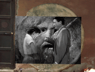
Santa Maria in Cosmedin before the war and today. The church is the home to la Bocca della Verità (Mouth of Truth), famously shown in the 1953 movie Roman Holiday starring Audrey Hepburn and Gregory Peck.


The Pyramid of Cestius beside the Porta San Paolo, standing at a fork between two ancient roads, the Via Ostiensis and another road that ran west to the Tiber along the approximate line of the modern Via della Marmorata. Due to its incorporation into the city's fortifications as part of the Aurelian walls, it is today one of the best-preserved ancient buildings in Rome.


Mapping Mussolini: Ritual and Cartography in Public Art during the Second Roman Empire HEATHER HYDE MINOR ABSTRACT: The four map tablets prominently displayed on the Via dell'Impero in the heart of ancient Rome have been either ignored or ridiculed by modern historians, urban planners and archaeologists. However, the creation of the maps and their installation in 1934 on a wall overlooking a newly created thoroughfare in the heart of Rome offer an opportunity to examine the interplay between maps and ritual, antiquity and imperialism, in the public art of Fascist Rome. The maps, the spectacles conducted around them, and the design of the road itself were all powerfully linked by the themes of commemoration and re-creation to stress the geopolitical objectives of the Fascist state, objectives underlined by the addition of a fifth map in 1936. KEYWORDS: Rome, 1932-1936, Benito Mussolini, cartography, public art, murals, Via dell'Impero, Fascist ritual and spectacle, geopolitics. 'There is material for meditation', said Benito Mussolini, sweeping his arm towards the four map tablets he was inaugurating on the Via dell'Impero. The Duce was addressing the crowd that just moments before, with the removal of the black drapes covering the maps, had seen the tablets for the first time.' Why Mussolini was unveiling maps and what these particular maps were doing next to one of the newest roads built in Rome make an interesting interlude in the history of mapping, ritual and public art in Fascist Rome. The close connections between imperialism, geopolitics and Fascist culture in Mussolini's Italy have been addressed by David Atkinson.2 My approach will be to investigate the uses of cartography in Fascist public art, thereby placing the maps on the Via dell'Impero in their social, semiotic and ritual contexts. Doing so will allow me to demonstrate how rituals of imperialism and geopolitics intersected in Fascist culture. We shall find that the themes of commemoration and re-enactment reso- nated powerfully in the street, its spectacles and the map tablets, and created a unified imperial rhetorical statement by the Fascist government. When the eminent critic of urban planning, Henry Hope Reed, set out nearly two generations ago to catalogue the eight worst public monuments in the history of Rome, he selected several projects created under Mussolini's rule (1922-1944). Of these, the construction of the Via dell'Impero-the broad street which today runs along the northern side of the Forum-was, according to Reed, easily one of Mussolini's worst interventions in the urban fabric of the city: As one of the most ambitious of Mussolini's attempts to re-create in Rome the city of the ancients, it is only fair to the planners to say that the Dictator traced the line of it himself, and boasted that it was constructed at his will. The only comment worth making on this carefully and extensively laid-out waste is that, with its concrete paths leading nowhere and its municipal lamp standards lighting up nothing, it is the most symbolic and fitting memorial to a dictatorship in existence.4 The road which Reed was attacking, the Via * Heather Hyde Minor, Department of Art and Archaeology, McCormick Hall, Princeton University, Princeton, NJ 08544, U.S.A. Tel: (1) 609 258 5910. Fax: (1) 609 258 0103. E-mail: hhminor@phoenix. princeton.edu C) Imago Mundi. Vol. 51, 1999, 147-162. 147 i,.C E V no 148" " t S Sm 4-4 :l7 dell'Impero, the modern-day Via dei Fori Imperiali, was arguably one of Mussolini's most treasured urban projects and a major site for ritual display. In a complex interplay of urban planning, state ceremony, ritual and public art, the road was used in the enshrining of Fascist ideology. Remarkably, perhaps, it continued to be used as the site of the annual celebrations of the foundation of the Italian Republic (2 June 1946) into the early 1970s. For more than twenty years after the fall of Mussolini, regiments representing the Italian army, including horses and tanks, marched past the head of state against a background of the various ancient forums. Since then, though, the road's original role has been forgotten by most of its users. Also forgotten is the history of the four map tablets clamped to the wall of the Basilica of Maxentius. The Maps on the Basilica of Maxentius Four stone maps, each about 4.6 square metres, are attached to the exterior of the north wall of the Basilica of Maxentius, overlooking the Via dell'Impero (Fig. 1). They show Europe as far north as the British Isles and the southern tip of Scandinavia, the Middle East as far as the Caspian Sea and the head of the Persian Gulf, and North Africa. The maps form a series in which three different types of marble create the cartographical image. A greywhite marble veined with green and grey mica (cipollino) indicates the sea, black Apuan marble portrays the regions lying outside the empire, and a white travertine from Trani highlights the Roman provinces. The Latin names of countries and seas are carved into the stone (Fig. 2). A panel of white marble in the bottom left corner of each map serves as a title cartouche. Each tablet is supported at the lower corners by an imperial eagle. The maps are arranged on the wall in chronological order. Starting with the tablet on the observer's left, the first map is entitled 'ROMA AI SUOI INIZI. SEC. VIII A.C.' [The beginning of Rome. 8th century B.C.] (Fig. 3). The next map shows the 'DOMINIO DI ROMA DOPO LE GVERRE PVNICHE-A. 146 A.C. [The territory of Rome after the Punic War in the year 146 B.C.]. The third depicts 'L'IMPERO ALLA MORTE D'AVGUSTO IMP. A. 14 D.C. [The Empire at the death of the Emperor Augustus in the year A.D. 14], and the fourth 'L'IMPERO AL TEMPO DI TRAIANO IMP. 98-117 D.C. [The Empire at the time of the Emperor Trajan A.D. 98-117] (Fig. 4). A fifth map (discussed below), depicting eastern Africa in the Fig. 2. Detail from the broken fifth map (see text below) to show the construction of the tablet in separate blocks and the use of different marbles to represent sea, the territorial expanse of the Italian Empire, and lands beyond. The identical construction had been used for the four Roman maps. (Photographed with permission from the Soprintendenza ai Beni Culturali del Comune di Roma by Gregory Acs.) grip of Mussolini's state, was added in October 1936 but was removed after the war. The colouring of the four original maps emphasizes the regime's imperial goals through the contrast of black and white. In Map 1, which portrays the beginnings of the Roman empire, the entire empire consists of a small white dot labelled 'ROMA'. On the following maps, the proportion of white to black increases to reflect the expansion of the empire, the maximum extent of which is marked on each map by a white boundary line. The line served both as a reminder of the past glory and the territorial extent of the Roman empire and as an exhortation to Fascist Italy to expand, as had ancient Rome. The colours also served to remind viewers of the Fascist government's claim that it was bringing culture and civilization to even the darkest and most barren reaches of the empire, a common theme of the regime's colonial rhetoric. Dino Grandi, for example, foreign minister from 1929 to 1932-a period which predated any strong interest in specifically East African expansionismhad called upon the government to enact the 'mission to civilise the black continent'.5 Artisans working under the supervision of the Fine Arts Department of the branch of state government responsible for Rome (the Ufficio di Belle Arti del Governatorato di Roma), made the maps in 1934, when Mussolini was preparing to 149 Fig. 3. Basilica of Maxentius, Map 1: 'The beginning of Rome. 8th century B.C.' The entire empire is shown by a white dot labelled Roma. (Archivio Fotografico, Monumenti Antichi e Scavi. Reproduced with permission from the Soprintendenza ai Beni Culturali del Comune di Roma.) invade Ethiopia. According to Antonio Mufioz (1884-1960), Inspector General of Antiquities and Fine Arts, they were to represent in an obvious way to the eyes of the people, both learned and uncultivated, the development of the dominion of Rome ... The Duce himself wanted these lapidary maps to be displayed in this location, teaching and providing a lesson for all; remember our pride, hope for our future.6 The tablets were unveiled on 21 April, the second most important day in the Fascist calendar, marking both the anniversary of the founding of Rome and (Fascist) Labour Day (Festa del Lavoro). Under the Fascist regime, dates and anniversaries were imbued with powerful meanings, and major events and rituals were celebrated at locations connected in some way to the themes stressed by the holiday. The unveiling of the maps on that particular day was thus doubly significant. First, the date of the founding of Rome signalled to the Fascists the creation of the Roman Empire and the birth of the Italian nation, two events that, the 150 government liked to stress, their own regime both encompassed and continued. Second, throughout Italy a central component of the Labour Day celebrations was the passage of members of the Fascist youth groups from one level of the Party to the next, an initiation rite which provided an occasion to display the allegedly growing strength of the Party. New youth members were enrolled, while those already in the Party celebrated both their commitment to Fascism and the years of service to the cause. The largest of these Leve Fasciste ceremonies took place in Rome. The Duce himself served as master of ceremonies at Constantine's Arch, close to the location of the map tablets. The Fascist youth battalions gathered in the Via dell'Impero, before marching down that street past the maps to the Arch for the ceremony. The tablets reflected the passage of time marked by the ritual. Just as the Fascist youth moved synchronically through different levels of the party as he grew up, so had the empire developed and flourished as it expanded under the Roman emperors-and would again flourish under Mussolini. if:i0i70i|iS:0glgi.5 .. ... .. .X ifE-;l giigl 1. A JAN Fig. 4. Basilica of Maxentius, Map 4: 'The Empire at the time of the Emperor Trajan A.D. 98-1 17'. By this time the Roman Empire, shown in white marble, has reached its greatest extent. (Archivio Fotografico, Monumenti Antichi e Scavi. Reproduced with permission from the Soprintendenza ai Beni Culturali del Comune di Roma.) The Via dell'Impero: Ceremony and Ritual How the maps functioned and the nature of their role in the Fascists' self-definition are better understood once the maps are situated within the context of the complex Via dell'Impero project. Before Mussolini opened up the area to the north of the excavated Forum, this was a zone of narrow streets and densely packed buildings, with an occasional patch of rough ground or partly excavated ancient structure. Mussolini's project was to create a processional avenue from the Victor Emmanuel Monument to the Colosseum (Fig. 5). Work began in 1931. The slicing of a broad road through a thriving residential and commercial district was an enormous undertaking; the removal of all nonancient structures from the Forum of Augustus alone displaced 400 people from their homes and caused the removal of some 40,000 cubic metres of rubble.7 Mussolini himself delivered the first blow, shouting 'Let the pickaxe speak!'8 As originally planned, the road was to be 700 metres long and 30 metres wide (it is in fact 850 metres long). It was built at breakneck speed and completed in eleven months in order to be ready for the tenth anniversary of Mussolini's March on Rome, to be celebrated on 28 October.9 Mussolini's new road was to honour Fascism's seizure of power, the so-called Fascist Revolt in March of 1922. The Ministry of Information compared Mussolini's 'March on Rome' with Sulla and Caesar's coups d'etat, and Fascist propaganda in general implied that Italy had crossed its Rubicon on the way to world power.'0 While such claims grossly exaggerated Mussolini's territorial ambitions, it is true that the commemoration of the March itself was manipulated into a powerful ideological tool. The reality of the original event, however, was very different. What came to be known as the March had in fact been a series of events which had taken place between 26 and 30 October, 1922. These had begun with a Fascist assembly in Naples, at which revolution was declared, and had ended with Mussolini's arrival in Rome by train after a night on the outskirts of the city on 30 October. On receiving the telegram inviting him to form a government, Mussolini advanced slowly from the station to the centre of 151 Palazzo Venezia PizaVeneziao-o xMapsolosse | Constantine's B 0 100 200 300 metres Arch I III I Fig. 5. Street plan north of the Forum, showing the alignment of the new Via dell'Impero (today Via dei Fori Imperiali) created by Benito Mussolini and ceremonially opened on 28 October 1932. The maps on the outer wall of the Basilica of Maxentius were unveiled on the 21 April 1934. the city, his progress deliberately leisurely in order to allow Fascist 'troops'-hungry and wet civilians armed with anything from pistols to table legstime to mobilize so that they would enter Rome simultaneously from all points of the compass. This relatively bloodless taking of the capital, later distorted by the regime into a violent seizure of power, has been described by modern historians as a 'colossal bluff'," and 'more opera buffa than revolution'. 12 The history of the occasion was carefully scripted, choreographed and documented by photography. By the time a map of the March was prominently displayed at the Exhibition of the Fascist Revolution in 1932, the event had become, in Mussolini's propaganda, a major military mobilization involving both northern and southern Italy which had struck with lightening speed. When the Via dell'Impero was built, the Fascists' version of the March had become the founding myth of the regime. It is clear from the earliest planning stages of the 152 road that ceremony and ritual were to be its main use and that the most important annual event was to be the commemoration of the March. Mussolini himself referred to the road at a ceremony on it in June 1933. Standing at the foot of the newly installed statue of Caesar, he proclaimed: Streets are also born under a sign of destiny. The Roman Via dell'Impero could not more speedily affirm the fate implied by its name. No sooner born, it has become the true heart of Rome. And here beats the most ardent life of the capital city of Italy.'3 The frequent use of the word 'destiny' points directly to the Fascists' goal of creating an Italian empire worthy of their ancestry. The new road was designed to provide a space where the connection between the Roman past, manifest in the ancient remains all around, and contemporary Fascist politics could be realized visually and spatially. When Via dell'Impero was opened on 28 October 1932, the Duce-dressed in his Black Shirt uniform adorned only with his Medal of the March on Rome-slowly rode his horse down its full length, stopping only to examine the Basilica of Maxentius and other Maxentius % monuments of the Forum and to make a brief speech at the Colosseum before returning by car to his office in Piazza Venezia.'4 The ceremony had begun with a rally in the Piazza Venezia, during which Mussolini reviewed his troops from the balcony of the Palazzo Venezia. Then 17,000 black-shirted Mutilati marched from the Piazza Venezia down the Via dell'Impero to the Colosseum, while other regiments stood to attention, filling the new street's broad pavements. Careful instructions had been issued as to the position of each regiment, the pace of the march, and the order of the passing troops. The impressive spectacle of legions of Black Shirts marching in Italian goose step (passo romano) must have been seen as a symbolic reversal of the March on Rome, away from, rather than to, the historical centre of the city and Mussolini's headquarters. The opening ceremonies were meticulously documented by the government. In the evening newspapers throughout Italy, the new road was invariably described as 'la pifi grande strada del mondo'.'5 The ceremony of 28 October 1932 was staged to re-enact the 1922 March. The legion that marched down the street contained only men who had 'marched' in the taking of the capital a decade earlier.'6 Such a re-enactment was not an entirely new idea; during the 1923 commemoration of the March, Black Shirts had re-traced the route of the March from Milan to Rome, finishing with a parade through Rome. What was different about the ceremony nine years later was, simply put, the venue. Mussolini's decision to cut the Via dell'Impero through the Forum area, and to have it completed in time for the ceremonies of 1932, invested the March with a new meaning and a new significance. By creating a ritual space in the centre of ancient Rome, and by using that space for the reenactment of the March, Mussolini was saturating the whole ritual with an historical, and explicitly imperial, grandeur. Further, by marching on, over and around the material remains of the Roman empire, he was asserting a palpable connection between his own empire and the ancient one, and providing a historical legitimization for his regime's adoption of imperial rhetoric. In their position on the outside wall of the Basilica of Maxentius, the maps served as a backcloth for the festivities staged on the street. They complemented the ancient ruins as a reminder of the power and the civilization of the Roman Empire. To those witnessing the annual re-enact- ment on the Via dell'Impero, the display of the increasing might of ancient Rome on the four maps was also a reminder of their government's ideological goals and dreams of empire. The four maps together construct a narrative depicting the empire from its earliest days until the period of its greatest territorial extent under Trajan.17 The cartographical narrative moves synchronically, echoing the progress of the March. The position of the maps was also tied to the March ritual, for the 1932 re-enactment ended at the Basilica of Maxentius, and the tablets on the Basilica's external wall, fronting the Via dell'Impero, mark that stop. As spatial markers connected with the 1932 ritual, the tablets also reminded viewers that the theme of empire implicit in both the historical March and its re-enactment needed to be continued. The Fifth Map on the Basilica The four maps placed on the Basilica of Maxentius must have had some success as pictorial representations of the regime's territorial aspirations; by 1935 versions of the map tablets began to appear in public spaces in cities and towns all over Italy.'8 They were also reproduced in magazines and newspapers, inspiring secondary art like the photomontage published in 1937 under a title taken directly from a speech made by Mussolini on 1 January 1925: 'Roma deve apparire meravigliosa a tutte le genti del mondo; vasta, ordinata, potete come fu ai tempi del primo impero d'Augusto' [Rome must appear marvellous to all of the peoples of the world; vast, ordered, powerful as at the time of the first Emperor, Augustus] (Fig. 6). In this speech, Mussolini had addressed the need to 'liberate' ancient monuments in Rome from the 'parasitic constructions' of post-antique development, but his theme of freeing the physical remains of antique Rome from modern corruption can easily be extended to encompass the Fascists' civilizing mission. The photomontage shows the famous statue of the She-Wolf, an allusion to the myth of Romulus and Remus and the foundation of ancient Rome, juxtaposed with the flags and standards of Fascist regiments which would have been widely recognized from the many military parades that had taken place throughout Italy by 1937. In the background of the photomontage is the fifth map, added to the wall on the Via dell'Impero on 28 October 1936.19 The fifth map was the final tablet in the series. 153 inhiut Fig. 6. Photomontage from Italia Imperiale (Milan, La rivista illustrata del Popolo d'Italia, 1937), with the fifth map in the background. (Courtesy of the Wolfsonian Institute.) Similar to the others in design and construction, it was composed of separate blocks (six in this case, each 141 X 261 cms) held together by metal clips and enclosed in a stone frame.20 The same marbles were used to colour the map in the same way, and the scale was the same. Since the new map extended deep into Africa, however, the fifth tablet turned out to be somewhat larger than the others, measuring 457 X 530 cms overall. The white marble plaque in the bottom left corner was also much larger; for instead of a simple title like the other maps, the Fascist map was to carry a lengthy inscription reproducing, under the title 'Fondazione dell'Impero', part of the decree of 9 May 1936 which established the Italian Empire and named King Victor Emmanuel of Italy as Emperor of Ethiopia.2' Antonio Mufioz, the Superintendent responsible for the original set of maps, was also responsible for the new map, the design of which bears his signature. The fifth map presented a different geographical focus from the earlier ones (Fig. 7). Whereas the 154 four original maps showed the whole of Europe and a small part of Africa and always placed Italy just to the left of centre, adoption of the same scale meant that on the fifth map Italy appeared at the top of the map. The rest of the tablet was taken up with the Middle East and, above all, some threequarters of the African continent, where Italy's African possessions were carefully delineated. The map was a proud synthesis and propagandist display of an accomplished colonial adventure. Just as the 1934 maps, and their imitations in other towns, exhorted Romans to remember their past as civilizers of the world, so the fifth map proclaimed recent achievements in the creation of the new empire. The temerity of the comparison between the empire of the Romans and that of a new Augustus, Benito Mussolini, had to be justified. The continuity of idea and ideals was reinforced cartographically through continuity of map scale and in Mussolini's proclamation of the new empire, on 10 May 1936: The Italian people have created the Empire with their blood, will make it fertile with their labour, and will defend it against whomsoever with their arms. In this certain hope, raise high-legionaries-your standards, your weapons and your hearts, and salute, after fifteen centuries, the re-appearance of the Empire on the predestined hills of Rome.22 The new map brought the Fascists' imperial project up to date, celebrating the conquest of Ethiopia as the event which finally established the Italian empire. It depicted current events rather than the ancient past. By the time it was ceremonially put into place on 28 October 1936, the March had come to be described as the 'sacro all'annuale della Rivoluzione vittoriosa' [sacred to the annual of the victorious revolution]. The addition of another map to the wall of the Basilica of Maxentius on the annual day of commemoration cemented the connection between the maps and the ritual of the March (Fig. 8). Like the original maps and the March ritual, the fifth map stressed the theme of commemoration. In general terms, it recorded Fascist campaigns in Africa. More specifically, it was officially dedicated to the fallen martyrs of the Fascist cause. Announcing the unveiling of the new map, the daily newspaper, Ii Popolo d'Italia, proclaimed that 'the name of this tablet is sculpted in the hearts of the generations who have had the privilege of sacrifice, of victory, of glory'.23 In the first issue of the review L'Urbe, it was pointed out that Mussolini's empire even exceeded Augustus's in the extent of its penetration of Africa and that it would 'prosper -LI:13:lA- _IM i ,:0XAVL j :;f: -N:7it:X: :: G MITIEI@f Fig.7.AntonioMufioz'sproject indicating the place of the inscr (see Fig. 10).: From L'Urbe, 1 (1936), Fig. 2. (Reproduced with permission from the Soprintendenza ai Beni Culturali del Comune di Roma.) through the Italian people's work and . . . be defended against all-comers by their arms'.24 The 'martyrs' of the Fascist regime played a major role in the mythology of the state and its ceremonies. When the fifth map was being set up, plans were well under way to build a new seat (the Palazzo del Littorio) for the secretariat of the National Party, to which the sanctuary dedicated to the martyrs-originally in the last room in the Exhibition of the Fascist Revolution (Mostra delta Rivoluzione Fascista), held at the Palazzo delle Esposizioni in 1932-was to be moved.25 Some of those who had sacrificed themselves in defence of the revolution were named in the exhibition catalogue, but care was taken not to disclose the precise number of 'martyrs', for, besides the 'hundreds and hundreds' of Black Shirts who had died in support of the Fascist cause, the ranks of the martyrs were considerably swelled by the less glorious dead, gangsters and social rebels.26 The fate of the fifth map was as inglorious as Mussolini's own. After his downfall in July 1943, the fifth map became the object of anti-Fascist sentiment and was defaced with red paint (Figs. 9 and 10). In November 1944, after the liberation of Rome, the Commissione Storia ed Arte agreed it should be removed. Eventually, in November 1945, five months after Mussolini's death, the provisional government ratified the commission's decision, and the map was removed from the basilica wall and disappeared from view.27 Only in January 1998 was it rediscovered in the basement of the Theatre of Marcellus, not far from the former Via dell'Im- pero but on the other side of the Forum. At the time of writing, the Comune of Rome's intention is to reassemble the map, make good the missing parts, and put it once more on display; not, however, on the wall of the Basilica of Maxentius but on a specially designed sloping plinth in the courtyard of the Museo della Civilta Romana in E.U.R.-another of Mussolini's monumental creations, built for the Esposizione Universale di Roma that had been planned, before the war, for 1942, but which never took place.28 The four original maps have 155 FJK :-V_ ,: Ci t _/ LIBfIA:; : T t - ' _S . _ 156 l .z to Fig. 9. Part of the broken and defaced fifth map, showing (in white) the Italian conquest of Ethiopia. (Photographed with permission from the Soprintendenza ai Beni Culturali del Comune di Roma by Gregory Acs.) -filg:W.,Mi:t,Ml..... *I.a,tt0i:.. _Sf0.iS:,0kj4X.fi;:;it!gfF0,:ALtE:SESE::X41tySASu0jfjFf:;i:iA40?X0'StltglitlJtl0A X s u S;XleSfd tyitllE E0XX4441 t000-;t0i f1 400ytyCL ;f:14 t ttE i:700 titttidi402 41 -LtX$;Q000 k | g : g :4 .: t t; 0 0 0 ; .d B >:: . @ . B W s: 0 s g ...... B l00: l00:0 000 i0 t;;0 0; 0040:|0 ; tt it|00 g;:00: tlttt i0|000i:it) t |:i5: ;4 t t ; il 0i 4 0: 4 ;;. ....... . .0g t;.:ti :gg: B : S iLL; i00 4 iLF g if iLE 4 D y iE; k i i T WiE E X f)7 y LjE i A; iilij455iEiELE--40 2 th iPESL iE. ... ........E l , iS f 4'; ;:! 010:l'tel's-$.0' @''''.X^ i';,--t';.$' ; Avilbilty -?.W ewjl<Wn?9';-,,Ei;ij1.........0l'0;Qti)")i | MX;^;;Md-Edt'ig b S) S; iN0 0; b j t * 0 Dt;WS f wSg a i g t ... .. Fig 10. Th defaced in crpto fro th fifth> map,000 quotingE par ofitii theii law signed0 oni 9i0 May 193 by Mussolin naming the Italian king, Victor Emmanuel, as Emperor of Ethiopia. (Photographed with per Soprintendenza ai Beni Culturali del Comune di Roma by Gregory Acs. ) 15 7 already been cleaned and remain in place on the Basilica of Maxentius. The Bronze Medallions Although a set of bronze medallions originally certainly had nothing at all to do with any of the maps on the wall of the Basilica of Maxentius, their recent reappearance has entangled them with Mussolini's maps. On that count alone, it is worth alluding to them here. More importantly, though, the record needs to be put straight.29 On 26 January 1998, the New York Times reported the rediscovery, in America, of nine basreliefs of beaten copper that had been taken from Rome in 1944.30 A rancher from the MissouriKansas border, Jay Anderson, had disclosed how his father James, of the 45th Infantry Division of the United States Army, had been among Allied troops entering Rome in June 1944. Seeing the medallions displayed on a wall, and having obtained the permission of his superior, Anderson senior took them down, packed them up and dispatched them home to the family ranch in Sheldon, Missouri. Neither James nor, in due course, his children, who inherited the medallions on their father's death in 1976, had any notion of the historical value of the booty. Although Jay Anderson had only said that the medallions had come from 'a marble map on the side of a building', the New York Times reporter, William Honan, associated them with Mussolini's fifth map, saying that the nine medallions (each of which measures some 90 X 122 cms) were attached to its surface-in fact, a physical impossibility.3' The alleged scenario induced historian Denis Mack Smith, in his interview with the New York Times, to interpret them as Mussolini's deliberately oblique expression of what he could not openly declare, namely his imperialist ambitions and his intention to conquer the world in the manner of his Roman predecessors. It soon struck scholars in Rome, however, that the medallions certainly did not come from the wall of the Basilica of Maxentius nor would they have been created as symbols of expansionist aims. Neither archaeologists working in the part of the Forum cut by the Via dell'Impero nor historians of inter-war architecture and urban development have ever come across any document or hint of such medallions around the maps.32 Instead, Giorgio Muratore, Professor of the History of 158 Contemporary Architecture at La Sapienza, Uni- \--Avr | fiA L LCAPO Fig. 11. Giorgio Muratore's speculative reconstruction of the map mural at the former Ministry for Italian Africa showing how the bronze medallions could have been positioned. (Redrawn by Alessandro Scafi with permission from Giorgio Muratore.) versity of Rome, suggests that while the medallions would indeed have come from a wall, and even from a map, the map in question was not Mussolini's fifth map on the Basilica but a mural in the entrance hall, or some other room in the newly built Ministry for Italian Africa, on the other side of the Via dell'Impero.33 In the absence of any information to date, Muratore has speculated how the medallions could have been placed on such a map (Fig. 11). Moreover, Muratore emphasises, the medallions celebrated, not intended conquests, but Italy's existing achievements in various parts of Africa. In this light, one medallion can be seen as representing Italian archaeology in Libya, another the Italians' engineering works at Suez, and another land reclamation and new settlement in Somalia and Ethiopia. Yet another probably represents the timber resources and ports of Senegal, while others referred to the Cape Town shipping route and to railway links within the continent. Lacking information about the ninth medallion, Muratore can speculate on only eight of them. Maps as Public Art in Fascist Rome In ordering maps to be fashioned from marble and displayed next to a major thoroughfare, Mussolini was following a precedent well-established in ancient Rome. Maps, pictographs and other geographical representations stressing imper- Fig. 12. A mosaic map: the ancient Roman Empire in the pavement at Ostiense station, Rome. (Courtesy of John Pinto.) ial values had often been created in Rome for public display.34 Severus's marble Forma Urbis Romae, which depicted the city of Rome in Vespasian's Forum of Peace, and Agrippa's so-called 'world map' in the Porticus Vispania, both served the Fascists as models for their public cartography." In his desire to associate himself with the glory and power of the Roman Empire, Mussolini frequently emphasized classical themes and visual elements in all kinds of art sponsored by his regime.36 To the Fascists, maps were particularly valuable tools in the way they could be used to promulgate two major components of their ideology, the idea that Roman history was Italian history, and the idea that one of the logical outcomes of this shared Roman past was colonial expansion. Defining Fascism for a broad audience in the Enciclopedia italiana (1932), Mussolini distilled the entire enterprise into a single concept, the 'will to empire', which, he explained, was an inevitable consequence of the vitality of the Italian race (SiC).37 The maps on the Via dell'Impero were thus neither the first nor the only time cartography and public art were combined by Mussolini's regime. Cartographical displays in public art and the popular press were taken up in earnest from the mid-1930s. For example, a number of maps were deployed as pavement mosaics at the Ostiense railway station in Rome, constructed specially, by Roberto Narducci, for Hitler's visit in 1938.38 One of these maps depicts the full extent of the Roman Empire, including the British Isles, with Italy in the centre (Fig. 12). The ancient empire, hatched with horizontal lines, highlighted Mussolini's call for the rebirth of empire. The map is framed by a Roman triumphal arch and the figure of a victorious Augustus with the imperial eagle. The whole composition fits well into the traditional use of public cartographical display to commemorate military campaigns and echoes the role of the map of Sardinia which Livy mentions was displayed in 174 B.C. in the temple of Mater Matuta to commemorate Tiberius Sempronious Gracchus's successful campaign on the island.39 The modern Ostiense pavement map had been completed for a highly specific audience on a particular occasion. It was designed to make a clear statement about Fascist pride in the idea of empire and in the importance, as they saw it, of linking the 'vitality of the Italian people' with the greatness of ancient Rome. Perhaps, in view of a long-standing rivalry with the German dictator, Mussolini had felt emboldened by the occasion to remind the Germans of the weight of the ancient Italian civilization.40 After all, while in Nuremberg, in 1934, Hitler had marked the first millennium of the Germanic empire, in 1938-the year of Hitler's visit to Rome-Mussolini was still celebrating the two thousandth anniversary of the birth of the ruler on whom he liked to model himself, the Emperor Augustus.4' More obliquely expressed geographical representations can be found in pavement mosaics created in the Foro Mussolini (now the Foro Italico), the athletic complex that Mussolini had begun building in 1932. One pictorial mosaic dating 159 .j ....... ... . ... Fig. 13. Pavement mosaic from the Foro Mussolini (now the Foro Italico), in which it is recorded that on '9 May, year XIV, Italy finally has her empire'. (Courtesy of John Pinto.) from about 1936 bears the triumphal inscription '9 May, year XIV, Italy finally has her empire'. It depicts the lion of Judah, representing Ethiopia, caged within fluted columns of an appropriately classical style (Fig. 13). For the Fascist regime in Italy, the twin themes of commemoration and re-creation of the past were deployed as tools of statecraft. Ancient Rome's achievements were to be matched by those of modern Italy. Ritual and rhetoric together provided both justification and articulation of the Fascists's policies. The maps created for Mussolini in 1934 and later on the specially created Via dell'Impero, at the Ostiense station, in the stadium in the Foro Mussolini and elsewhere in Rome referred to the grandeur of the Roman mantle and the worthiness of the new Italian empire to inherit it. The artistic format (large-scale marble tablets, mosaics), the symbolism (the imperial eagle, the emperor Augustus), and other details of formal art came directly from classical Rome.42 As part of public art, the maps on the Via dell'Impero were powerful tools in the forging of connection between classical Roman civilization and that of the empire of the Fascists. Acknowledgements: I would like to thank Richard Talbert, John Pinto, Friedemann Scriba, Francesco Lombardi and the staff of the Wolfsonian Library, Miami Beach, for their assistance with my research for this paper. I am particularly indebted to Giorgio Muratore and Alessandro Scafi for their invaluable and most generous help. NOTES AND REFERENCES 1. Il Popolo d'Italia, 24 April 1934, p. 9. 2. David Atkinson, 'Geopolitics, cartography, and geographical knowledge: envisioning Africa from Fascist Italy', in Geography and Imperialism, 1820-1940, ed. Morag Bell, Robin Butlin and Michael Heffernan (Manchester, University of Manchester Press, 1995), 290-332. 3. J. B. Harley, 'Maps, knowledge and power', in The Iconography of Landscape, ed. Denis Cosgrove and Stephen Daniels (Cambridge, Cambridge University Press, 1988), 277-312. 4. Henry Hope Reed, 'Rome: the third sack', Architectural Review 107 (1950): 108. 5. Denis Mack Smith, Mussolini's Roman Empire (New York, Longman, 1976), 59. 6. Antonio Mufioz, Roma di Mussolini (Rome, Fratelli Treves, 1935), 221-22. All translations of the Italian are by the author. 7. Ronald Ridley, 'Augusti manes volitant per auras: the archaeology of Rome under the Fascists', Xenia (Antiqua) 11 (1986): 22. 8. A cry often heard around the city of Rome throughout the 'years of consensus' from 1929 to 1936. See Volume 1 of Renzo de Felice, Mussolini, Il Duce: Gli anni del consenso 1929-36 (Turin, G. Einaudi, 1974), for the argument that from the time of the March on Rome in 1922 until the capture of Ethiopia in 1936, the regime focused on trying to build up consensus through creating an ideological and physical Fascist infrastructure. According to De Felice's argument, consolidation and legitimization of power were key concerns. This time of tranquillity was interrupted by colonial expansion. See also Antonio Cederna, Mussolini urbanista: Lo sventramento di Roma negli anni del consenso (2nd ed., Rome and Bari, Laterza, 1979). 9. A 1926 decree stated that 28 October was to be the official day of commemoration for the March on Rome. 10. As noted by Romke Visser, 'Fascist doctrine and the cult of RomanitW', Journal of Contemporary History 27 Manuscript submitted June 1998. Revised paper received October (1992): 6. 160 1998. 11. Adrian Lyttelton, The Seizure of Power: Fascism in Italy, 1919-1929, revised and ed. Robert Vivarelli (Princeton, Princeton University Press, 1987), 85. 12. Gaetano Salvemini, The Origins of Fascism in Italy (New York, Harper & Row, 1973), 382. 13. L'illustrazione italiana, 4 June 1933, p. 848. The statue of Caesar was erected in April 1933. 14. Il Messaggero, 29 October 1932, section 1, p. 14. For a highly detailed account of the opening ceremony, see Il Popolo d'Italia, 29 October 1932, as well as the special edition of 28 October. Also see Emilio Gentile's treatment of the Fascist's creation of rituals that were both political and religious in tone in his The Sacralization of Politics in Fascist Italy (Cambridge, Cambridge University Press, 1996). 15. 'The greatest street in the whole world', Scaramuccia, 'La Settimana-La via dell' Impero', L'illustrazione italiana, 6 November 1932, p. 660. 16. Although historians seriously doubt the veracity of the regime's claim that 17,000 troops descended on Rome in 1922, by having that number of 'veterans' march in 1932, Mussolini was deliberately manufacturing a recreation of the March as the regime collectively sought to remember it. dell'Impero). The 'martyrs' were, however, commemorated in other ways, such as the street names Piazza dei Martiri Fascisti (now Piazza Don Minzoni) and Viale dei Martiri Fascisti (now Viale Bruno Buozzi). 27. Details kindly supplied by Professor Giorgio Muratore. 28. The original acronym for E.U.R, was E'42. 29. I am indebted to Professor Giorgio Muratore for updating me in respect of the medallions and for permission to reproduce his hypothetical reconstruction of the relationship of the medallions with a map of Africa in the Ministry for Italian Africa (Fig. 10). 30. See William Honan, 'Mussolini medallions turn up at ranch', New York Times, 26 January 1998, p. 12, for the history of the medallions. This was also reported in Il Messaggero, 26 January 1998, p. 15. 31. Nine medallions, each measuring some 90 X 122 cms, could not fit onto a surface measuring only 457 X 530 cms. 32. Giorgio Muratore, 'Nove pezzi per l'Aventino', Il Venerdi di Repubblica (supplement to La Repubblica), 20 February 1998, pp. 30-33. See also 'I bronzi del Missouri' in the same supplement (pp. 26-29). 17. By 117, the date referred to in the fourth map, Trajan had conquered Dacia and moved into Mesopota- mia. Organization. 18. Shepard Stone, 'Reminding Romans of the grandeur that was theirs', New York Times, 13 October 1935, section 4, p. 6. The article is accompanied by a photograph of the map tablets. 19. Giovanni Agnelli and Achille Starace, eds., Italia Imperiale (Milan, La rivista illustrata del Popolo d'Italia, 1937). Francesco Sapori, L'arte e il Duce (Milan, A. Mondadori, 1932), 517. The fifth map was reproduced in other publications. For example, see the exhibition 34. 0. A. W. Dilke, Greek and Roman Maps (London, Thames and Hudson, 1985). 35. For these maps and their political contexts, see 0. A. W. Dilke, 'Maps in the service of the state: Roman cartography to the end of the Augustan era', in the History of Cartography, vol. 1, Cartography in Prehistoric, Ancient, and Medieval Europe and the Mediterranean, ed. J. B. Harley and David Woodward (Chicago, University of Chicago Press, 1987), 207-9; and Liba Taub, 'The historical function of catalogue Ente Autonomo fiera campionaria di Tripoli sotthoe Forma Urbis Romae', Imago Mundi 45 (1993): 9-19, l'alto patronato del Duce, XI manifestazione internazionale intercoloniale, prima mostra coloniale dell'impero Fascista, anno xv, II dell'impero (Rome, March 1937), iv, where the fifth map in reproduced at the front of the volume after portraits of the king and Mussolini. 20. Technical details of the fifth map are from material kindly supplied by Alessandro Scafi. I am greatly indebted to Dott. Scafi for his invaluable assistance in updating my information on this map and for his help in obtaining photographs and illustrations. esp. 15-17. 36. See Emily Braun, 'Political rhetoric and poetic irony: the uses of classicism in Fascist Italy', in On Classic Ground: Picasso, Liger, de Chirico and the New Classicism, 1910-1930, ed. Elizabeth Cowling and Jennifer Mundy (London, Tate Gallery, 1990), 351. 37. The word used is razza. Although the article is ascribed to Mussolini, and certainly was only printed under his name with his permission, in all probability it would not have been written by him. 21. Regio decreto-legge N. 754, Art. 1: 'I territori e le genti che appartartenevano all'Impero d'Etiopia vengono posti sotto la sovranita piena ed intera del Regno d'Italia. U1 a rubber flooring. titolo d'Imperatore d'Etiopia e assunto per se e per i suoi successori dal re d'Italia'. 22. Reproduced in part in Il Popolo d'Italia, 11 May 1936, p. 1. 23. Il Popolo d'Italia, 28 October 1936, p. 2. The paper had been edited until his death in 1931 by Mussolini's brother. 24. Giuseppe Bottai, 'La carta marmorea dell'Impero fascista', L'Urbe, 1 (1936): 3-4, quotation on 4. 25. Gentile, Sacralization of Politics (see note 14), 125. 26. I owe these points to Professor Giorgio Muratore. When the exhibition of the Fascist Revolution was moved in 1934 to the National Gallery of Modern Art, the martyrs' room was not included, for by then it was intended to make that room the symbolic centre of a future Palazzo Littorio (initially planned to be on the Via 39. Taub, 'The historical function of the Forma Urbis Romae' (see note 35), 12. 40. Elizabeth Wiskemann, Fascism in Italy: Its Development and Influence (London, Macmillan, 1969), 56-59, makes a case for what she sees as the long-standing rivalry between Hitler and Mussolini. 41. Mussolini's self-fashioning as Augustus was problematic for the Duce himself. See Mariella Cagnetta, 'II mito di Augusto e la "rivoluzione" Fascista', Quaderni di storia (January-June 1976): 139-67. Two examples of Fascist era literature that elucidate the relationship between Mussolini and Augustus are C. Amati, Augusto (Velletri, Tipografico G. Zampetti, 1938), and E. Balbo, Augusto e Mussolini (Rome, Casa Editrice Pinciana, 1937). 42. Visser, 'Fascist doctrine and the cult of Romanita' (see note 10), 7. 33. Muratore 'Nove pezzi' (see note 32), 33, with figure; the building now houses the Food and Agriculture 38. I would like to thank John Pinto for drawing my attention to this mosaic. The mosaic is usually covered by 161 162 Mapping Mussolini: les rites et les cartes dans l'art urbain du deuxieme empire romain Les quatre cartes placees sur des plaques bien en vue sur la Via dell'Impero au coeur de la Rome antique ont ete soit ignorees soit tournees en ridicule par les historiens modernes, les architectes urbains et les archeologues. Pourtant, la realisation de ces cartes et leurs insertion en 1934 sur un mur surplombant une artere nouvellement ouverte au coeur de Rome offrent une occasion d'etudier les interferences entres cartes et rites, antiquite et imperialisme dans l'art urbain de la Rome fasciste. Ces cartes, les spectacles donnes a leur propos, et le trace de la voie elle-meme, etaient tous fortement lies aux themes de la commemoration et d'une re-creation pour faire ressortir les objectifs geopolitiques de l'etat fasciste, objectifs soulignes par l'adjonction d'une cinquieme carte en 1936. Kartographie im Zeremoniell des faschistischen Italiens unter Mussolini Die vier Tafeln mit kartographischen Darstellungen, die an der Via dell'Impero im Herzen des alten Roms deutlich sichtbar prasentiert sind, wurden bisher von Historikern, Stadtplanern und Archaologen entweder ignoriert oder belachelt. Ihre Gestaltung und Anbringung im Jahre 1934 an einer Mauer im Blickfeld der neu geschaffenen Durchgangsstra1ge im Zentrum der Stadt bietet die Moglichkeit, sich mit der Wechselwirkung zwischen Karten und Zeremoniell, Antike und Imperialismus in der offiziellen Kunst des faschistischen Roms auseinanderzusetzen. Die Tafeln, die Aufmarsche, die um sie herum stattfanden und die Konzeption der ganzen Stra1ge waren eng verknupft mit der Besinnung auf historisierende Ideale und der Vorstellung von der Wiederaufrichtung alter Grobe. All dies diente dazu, die geopolitischen Ziele des faschistischen Staates zu propagieren. Die Hinzufugung einer funften Karte im Jahr 1936 macht diesen Zusammenhang nochmals deutlich. Institut Cartografic de Catalunya, Barcelona Eleventh lecture series in the History of Cartography 21-25 February 2000 Approaches and Challenges in a World-Wide History of Cartography Project This five-day course closes the cycle of lectures given annually since 1990. The 15 lectures, in English, wil presented by Professor David Woodward (University of Wisconsin), Dr Cordell Yee (St John's College, Annapolis) and Dr Catherine Delano Smith (Institute of Historical Research, London). The course is designed for students in the third cycle of their doctoral studies at Spanish universities undergraduates taking courses in the history of cartography or related subjects, lecturers from universities i Catalonia, Spain and Portugal, librarians, map collectors and anybody with an active interest in the history maps, and in the problems and issues involved in their study. Those wishing to attend are invited to contact Montserrat Galera i Monegal, Cartoteca de Catalunya, Instit CartogrAfic de Catalunya, Parc de Montjuic, 03038 Barcelona, Spain.