Straubing: The Gäuboden Festival's Nazi Blood and Soil Mythology, and the remaining Nazi eagle

Straubing, situated on the Danube in Lower Bavaria, became an early centre of Nazi activity in the region due to the combination of agricultural economic distress, conservative Catholic social structures, and the organisational energy of local party activists. Straubing was one of the first Bavarian cities that experienced
by the November revolution at the end of the First World War. On
November 8, 1918, a demonstration train liberated prisoners. Already on
the afternoon of November 9 a workers 'and soldiers' council had formed,
in the evening a council of citizens. The Nazi Party established its first branch in Straubing in 1923, drawing initial membership from war veterans, small farmers, and tradesmen who had been radicalised by the hyperinflation crisis and the perceived failures of the Weimar Republic. The local organiser during this formative period was Heinrich Gareis, a former soldier who recruited amongst the rural communities of the Gäuboden, the fertile agricultural plain surrounding Straubing that constituted one of Bavaria's most productive farming regions. The economic vulnerability of the Gäuboden's farmers to fluctuating grain prices and rising debt made the area particularly receptive to the Nazi Party's agrarian programme, which promised debt relief, protection from foreign competition, and the restoration of the peasant farmer to the centre of German national life. The Gäuboden agricultural festival, Straubing's annual harvest celebration and one of the largest popular festivals in Bavaria, was appropriated by the Nazi Party from 1933 onwards. The festival, which attracted over 100,000 visitors annually, was transformed into a showcase for Nazi agrarian ideology. The Reich Food Estate, the Nazi organisation controlling agricultural production under the leadership of Richard Walther Darré, used the Gäuboden festival to promote the Blood and Soil ideology that romanticised the German peasant farmer as the racial foundation of the nation. Nazi banners, symbols, and uniformed officials dominated the festival grounds, and speeches by regional and national party leaders replaced the traditional civic ceremonies. Darré himself attended the festival on at least two occasions during the 1930s, delivering addresses that framed the Gäuboden farmers as exemplary specimens of the Nordic agricultural class.
 The town before the war and after looking from
the east towards the old town showing the church of St. Peter, St.
Peter school and the Schlachthof, now serving as an art gallery. Following the failed Beer Hall Putsch of November 9, 1923, the Straubing branch was formally dissolved along with all other Nazi Party organisations across Bavaria. However, the network survived through informal associations and front groups, and when the party was re-established in February 1925, the Straubing branch reconstituted rapidly. Hitler
delivered a speech entitled "Der Weg zur Freiheit" at the former Kronensaal on Wednesday
April 11, 1928 from 20.00 to 23.00 here in Straubing. According to the
subsequent police report, it was attended by roughly 1,200 people and
was headed by Nazi city councillor Hanns Oberlindober who was apparently
an effective public speaker, becoming a Reichsredner for the party after
1928 and was elected to the Reichstag in the breakthrough election of
September 1930. At that time he was also named to head the newly formed
section in the national party directorate dealing with disabled
veterans. The meeting had originally been set for March 15, 1928 but had
to be postponed due to Hitler's illness.
The town before the war and after looking from
the east towards the old town showing the church of St. Peter, St.
Peter school and the Schlachthof, now serving as an art gallery. Following the failed Beer Hall Putsch of November 9, 1923, the Straubing branch was formally dissolved along with all other Nazi Party organisations across Bavaria. However, the network survived through informal associations and front groups, and when the party was re-established in February 1925, the Straubing branch reconstituted rapidly. Hitler
delivered a speech entitled "Der Weg zur Freiheit" at the former Kronensaal on Wednesday
April 11, 1928 from 20.00 to 23.00 here in Straubing. According to the
subsequent police report, it was attended by roughly 1,200 people and
was headed by Nazi city councillor Hanns Oberlindober who was apparently
an effective public speaker, becoming a Reichsredner for the party after
1928 and was elected to the Reichstag in the breakthrough election of
September 1930. At that time he was also named to head the newly formed
section in the national party directorate dealing with disabled
veterans. The meeting had originally been set for March 15, 1928 but had
to be postponed due to Hitler's illness.

 Himmler
too spoke here June 4, 1925, attacking the Dawes Plan, the 1924
adjustment by the Germans and the Allies of the reparations imposed by
the Versailles Treaty, in his speech "The Freemasons’ Lodge as a Tool of
the Jews."
Himmler
too spoke here June 4, 1925, attacking the Dawes Plan, the 1924
adjustment by the Germans and the Allies of the reparations imposed by
the Versailles Treaty, in his speech "The Freemasons’ Lodge as a Tool of
the Jews." After
the war Göring's wife Emmy, together with her niece, sister, and their
nurse Christa Gormanns were incarcerated in Straubing's gaol, and his
daughter Edda was put in an orphanage. Since the end of the 19th
century, this has been largest Bavarian penitentiary; by the end of the
20th century, the Bavarian Correctional Academy and an institution for
forensic psychiatry were added. Today, offenders with prison sentences
of more than five years are housed in the Straubing prison. The former
prison doctor during during the Nazi era, Theodor Viernstein, considered
that "enemies of the race, enemies of society" had to be removed from the chain of heredity as fast as possible.  His
successor, Hans Trunk, actually proposed to have up to a third of the
prison’s inmates sterilised, a figure considered too high even by the
local Hereditary Health Court. As Richard J. Evans writes
His
successor, Hans Trunk, actually proposed to have up to a third of the
prison’s inmates sterilised, a figure considered too high even by the
local Hereditary Health Court. As Richard J. Evans writes
 His
successor, Hans Trunk, actually proposed to have up to a third of the
prison’s inmates sterilised, a figure considered too high even by the
local Hereditary Health Court. As Richard J. Evans writes
His
successor, Hans Trunk, actually proposed to have up to a third of the
prison’s inmates sterilised, a figure considered too high even by the
local Hereditary Health Court. As Richard J. Evans writes It was hardly surprising that prisoners were over-represented amongst the compulsorily sterilised, with nearly 5,400 subjected to this procedure by December 1939. It was equally unsurprising that the threat of a vasectomy or hysterectomy spread fear amongst prison inmates, who often told each other the correct answers to the intelligence tests administered by the doctors and learned them off by heart.
By
the Reichstag election of September 14, 1930, the Nazi Party secured
approximately 18% of the vote in the Straubing district, a significant
result in a region where the Bavarian People's Party had traditionally
commanded overwhelming Catholic loyalty. By the election of July 31,
1932, the Nazi share in the district had risen to approximately 29%, and
by the final semi-free election of March 5, 1933, it exceeded 40%,
although the Bavarian People's Party retained a substantial minority
following amongst the devout rural population.

 Their
speeches at the rally in Großdeutschlandplatz in June 1940 weren't
isolated incidents but part of a broader pattern of local authorities
actively participating in the dissemination of Nazi policies. By the end
of the regime's rule, its social impact on Straubing was profound, with
the regime's policies eroding traditional Bavarian values. The
Hitlerjugend, with 4,900 members by 1944, enforced ideological
indoctrination, requiring youths to attend weekly drills. In 1943 forty
parents, including farmer Hans Gruber, were fined 300 Reichsmarks for
withholding children from participation, indicating a reluctant
compliance. The Straubinger Tagblatt amplified war propaganda,
reporting exaggerated victories like the 1942 "capture" of Sevastopol"
whilst suppressing news of 1,500 local deaths on the Eastern Front. The
Catholic Church's role evolved, with Bishop Buchberger issuing a 1943
letter endorsing the war as a "holy struggle," though privately help to
shelter Jewish children in Straubing convents whilst Father Karl Weiss
was arrested in 1944 for criticising deportations. That year 200
residents attended an illegal prayer meeting led by laywoman Anna
Mueller, defying Gestapo surveillance. There were other examples of
minor acts of resistance, such as the 1940 defacement of Nazi posters by
anonymous youths, which required twenty SA members to patrol
Theresienplatz for a week. The Gestapo's presence, established in
Straubing in 1934 with a staff of ten, maintained surveillance over the
population, recording 120 arrests for political offences between 1933
and 1939.
Their
speeches at the rally in Großdeutschlandplatz in June 1940 weren't
isolated incidents but part of a broader pattern of local authorities
actively participating in the dissemination of Nazi policies. By the end
of the regime's rule, its social impact on Straubing was profound, with
the regime's policies eroding traditional Bavarian values. The
Hitlerjugend, with 4,900 members by 1944, enforced ideological
indoctrination, requiring youths to attend weekly drills. In 1943 forty
parents, including farmer Hans Gruber, were fined 300 Reichsmarks for
withholding children from participation, indicating a reluctant
compliance. The Straubinger Tagblatt amplified war propaganda,
reporting exaggerated victories like the 1942 "capture" of Sevastopol"
whilst suppressing news of 1,500 local deaths on the Eastern Front. The
Catholic Church's role evolved, with Bishop Buchberger issuing a 1943
letter endorsing the war as a "holy struggle," though privately help to
shelter Jewish children in Straubing convents whilst Father Karl Weiss
was arrested in 1944 for criticising deportations. That year 200
residents attended an illegal prayer meeting led by laywoman Anna
Mueller, defying Gestapo surveillance. There were other examples of
minor acts of resistance, such as the 1940 defacement of Nazi posters by
anonymous youths, which required twenty SA members to patrol
Theresienplatz for a week. The Gestapo's presence, established in
Straubing in 1934 with a staff of ten, maintained surveillance over the
population, recording 120 arrests for political offences between 1933
and 1939. 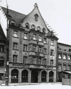
The
publishing house at Ludwigsplatz 32 where the anti-Nazi Straubinger Tagblatt was eventually closed down by the Nazi regime. Both its publisher Georg Huber Sr. and his son Georg Huber Jr. refused to join the party or any of its organisations or to give the Hitler salute. After Alfons Putz became the the new Nazi district leader in June 1934, he wanted to make the building a Nazi printing centre, replacing the Straubinger Tagblatt with the Nazi newspaper "Bavarian Ostwacht" or "Bavarian Ostmark". On
May 29, 1935 Huber Sr., who had been denounced for anti-Nazi
statements, was taken into 'protective custody.' That same day the Nazis
had organised a rally against the Straubinger Tagblatt in the main
square which was then banned for two days. By September that year it
finally closed for
"political unreliability" and Huber was finally excluded from the Reich Association of German Publishers for the same reason. He thus lost the right to work as a publisher and was left to hand over the business to his son Dr. Georg Huber. The
company had about seventy employees at this time with the paper
enjoying a circulation of over 12,000. Given that Georg Huber married
the Swiss Elsy Wipf, daughter of a packaging entrepreneur from Zurich, a
complete Nazi takeover of the "Straubinger Tagblatt" was prevented
leading to a compromise - a presumably unique case in Nazi press policy
- the "Verlag Straubinger Tagblatt GmbH" was founded, which accounted
for 55% of the Nazi-owned Phönix Zeitungsverlag GmbH with Huber owning
the rest. The content of the Straubinger Tagblatt
was now the same, but thanks to the loyalty of its readers and its
continued extensive local reporting it continued to hold its own against
their Nazi press competitors- the Bavarian Ostmark printed their last edition in October 1939.
 The paper did however describe how the "Swastika flags waved over the
city as banners of victory" during the 1938 commemoration of the failed
Hitler putsch in 1923. The sixteen putschists were glorified as "martyrs
of the movement" in the crowded Kronensaal on Großdeutschlandplatz where the wife and baby Drake Winston are shown towards the stadturm and Tibertiusbrunnen and during
a rally in June 1940,
when Straubing held its Kriegskreistag, with some 20,000 people
gathering at Großdeutschlandplatz, the name given to Ludwigsplatz in 1938
after the annexation of Austria.
In the main speech, district leader Alfons Putz also emphasised that
only a few hours earlier the German legation secretary, von Rath, died
in Paris, "hit by a Jewish criminal's bullet." The Nazis took advantage
of this assassination and initiated the Night of Broken Glass. After the
celebration in the Kronensaal many Nazis met in pubs such as the Café
Alfons on Innere Passauer Straße.
After a phone call Putz ordered them all to come to the district
management at Rennbahnstraße 1 from where, as well as from the office of
the NSKK (National Socialist Driver Corps) on the corner of Stadtgraben
and Flurlgasse, individual squads were sent out targeting Jewish
citizens such as businessman Leopold Stein, then just under 24 years
old, who lived on Ludwigsplatz.
The paper did however describe how the "Swastika flags waved over the
city as banners of victory" during the 1938 commemoration of the failed
Hitler putsch in 1923. The sixteen putschists were glorified as "martyrs
of the movement" in the crowded Kronensaal on Großdeutschlandplatz where the wife and baby Drake Winston are shown towards the stadturm and Tibertiusbrunnen and during
a rally in June 1940,
when Straubing held its Kriegskreistag, with some 20,000 people
gathering at Großdeutschlandplatz, the name given to Ludwigsplatz in 1938
after the annexation of Austria.
In the main speech, district leader Alfons Putz also emphasised that
only a few hours earlier the German legation secretary, von Rath, died
in Paris, "hit by a Jewish criminal's bullet." The Nazis took advantage
of this assassination and initiated the Night of Broken Glass. After the
celebration in the Kronensaal many Nazis met in pubs such as the Café
Alfons on Innere Passauer Straße.
After a phone call Putz ordered them all to come to the district
management at Rennbahnstraße 1 from where, as well as from the office of
the NSKK (National Socialist Driver Corps) on the corner of Stadtgraben
and Flurlgasse, individual squads were sent out targeting Jewish
citizens such as businessman Leopold Stein, then just under 24 years
old, who lived on Ludwigsplatz. 
The Straubinger Tagblatt's commercial printing and publishing continued despite Nazi harassment
such as the confiscation of machinery and cars, monitoring of mail and
telephone, reduction of paper and gasoline allocations, whilst several
other local newspapers were shut down under the pretext of wartime
reasons by the Nazis. Thus, in the autumn of 1944, 80% of private
newspapers from before 1933 had disappeared. The last issue of Straubinger Tagblatt in
the Third Reich appeared on April 18, 1945; the heavy air raid that hit
Straubing that day disrupting the supply of electricity, water and gas.

The
arms used in the top-left canton on the reverse of the Straubing
Deutschland Erwache standard reflects the change made in 1923 by the
Nazis to remove the French influence shown in the fleur-de-lis, which
were added in the 18th century. The arms have since been restored
officially, but the spitaltor dating from 1628 shows the version
favoured by the Nazis.
The two pages shown are from Deutschland Erwache - The History and Development of the Nazi Party and the “Germany Awake” Standards.
The two pages shown are from Deutschland Erwache - The History and Development of the Nazi Party and the “Germany Awake” Standards.
 The
Hans-Schemm-Schule, named after the founder of the National Socialist
Teachers' Federation in 1927 and today, renamed St. Jakobsschule. Schemm
built the organisation under guiding principles that were clearly
anti-democratic, anti-Semitic and anti-Communist, as seen in a number of
his quotations as when he proclaimed how "[w]e are not objective – we
are German!" and declared "that a Jew should dangle from every lamppost." In 1928, he became a member of the Bavarian Landtag. Schemm
has been described by Thomas Childers (119)
as "perhaps the most skilled and dynamic of Franconia's Nazi leaders."
Schemm also took on the role of publicist in the late 1920s when for a
brief period he took over the leadership of several Nazi newspapers such
as Streiter, Weckruf and Nationale Zeitung before founding his own newspaper in April 1929; in August of that year he launched the Nationalsozialistische Lehrerzeitung,
the National Socialist Teachers League's (NSLB) journalistic organ. On
October 1, 1930 came the first edition of the weekly newspaper Kampf für deutsche Freiheit und Kultur
("Struggle for German Freedom and Culture"), which was published by
Schemm, and whose circulation rose from 3,000 in the beginning to 20,000
by 1932.
The
Hans-Schemm-Schule, named after the founder of the National Socialist
Teachers' Federation in 1927 and today, renamed St. Jakobsschule. Schemm
built the organisation under guiding principles that were clearly
anti-democratic, anti-Semitic and anti-Communist, as seen in a number of
his quotations as when he proclaimed how "[w]e are not objective – we
are German!" and declared "that a Jew should dangle from every lamppost." In 1928, he became a member of the Bavarian Landtag. Schemm
has been described by Thomas Childers (119)
as "perhaps the most skilled and dynamic of Franconia's Nazi leaders."
Schemm also took on the role of publicist in the late 1920s when for a
brief period he took over the leadership of several Nazi newspapers such
as Streiter, Weckruf and Nationale Zeitung before founding his own newspaper in April 1929; in August of that year he launched the Nationalsozialistische Lehrerzeitung,
the National Socialist Teachers League's (NSLB) journalistic organ. On
October 1, 1930 came the first edition of the weekly newspaper Kampf für deutsche Freiheit und Kultur
("Struggle for German Freedom and Culture"), which was published by
Schemm, and whose circulation rose from 3,000 in the beginning to 20,000
by 1932.
In
April 1933 Schemm arrived in Passau to attend the laying of the corner
stone for the Hall of the Nibelungs where he also spoke at a mass rally;
Passau too subsequently honoured Schemm by dedicating a street and a
school to him. In March 1935 Schemm was seriously injured in an aircraft
crash. Although Hitler personally ordered Berlin Professor Ferdinand
Sauerbruch to fly to Bayreuth, Schemm, however, succumbed to his
injuries on March 5 before the professor's arrival.

Rosengasse
then and now. Embedded in a wall on the right is the inscription in
Hebrew shown below with Drake Winston, a duplicate of what is now in the town museum. Roughly
translated, it reads
The crown of our race fell with the death of our father Rabbi Azariah, the son of Jose, who stepped into another world on the eve of Shabbat, the 26th, the month of Iyar, the 88th.
In
1933 there were 110 Jewish residents in the town. Immediately after the
Nazi takeover of power, Straubing's Jewish population faced various
acts of violence. In his book Hitler and Nazism, Dick Geary writes specifically how "[i]n Straubing
Nazi excesses against local Jews ended in murder." For example, less than two months after Hitler's appointment as chancellor, Otto Selz, a Jewish cattle and goods trader, was dragged out
of the house by several men, driven towards Leiblfing and, after
torture, shot in a forest near Soplterstein on March 15. He is considered the first of Straubing's Jews to have been murdered by the Nazis.  After the body was found
and then dissected, it was brought to Straubing and buried two days
later in the Jewish cemetery in Regensburg. Eight
months later, the Nazis broke into the murdered man's house, hoisted
the Nazi flag and chased away the administrator and the economic
manager. The search for the murderers
was initially thoroughly engaged by the police and public prosecutor's
offices in 1933, but was quickly stopped from
above, especially by the Bavarian political police. After 1945 efforts
were made to investigate again, but this was complicated by the long
period of time and the disappearance or death of several suspects. The
motive for the murder was clearly seen in the conflict between Otto Selz
and Julius Streicher, Nazi Gauleiter of Franconia and editor of the
Nazi newspaper Der Stürmer. In August 1933, Jews were banned from bathing in the Danube.
After the body was found
and then dissected, it was brought to Straubing and buried two days
later in the Jewish cemetery in Regensburg. Eight
months later, the Nazis broke into the murdered man's house, hoisted
the Nazi flag and chased away the administrator and the economic
manager. The search for the murderers
was initially thoroughly engaged by the police and public prosecutor's
offices in 1933, but was quickly stopped from
above, especially by the Bavarian political police. After 1945 efforts
were made to investigate again, but this was complicated by the long
period of time and the disappearance or death of several suspects. The
motive for the murder was clearly seen in the conflict between Otto Selz
and Julius Streicher, Nazi Gauleiter of Franconia and editor of the
Nazi newspaper Der Stürmer. In August 1933, Jews were banned from bathing in the Danube.
At least ten of the town's Jews emigrated outside the country over the next few years whilst eleven moved to other places in Germany. During Kristallnacht in 1938, the interior of the synagogue, shown below, and a Jewish shoe shop was looted. Of the thirty local Jews who remained in April 1942, 21 were deported to Piaski near Lublin and murdered, five were deported in September 1942 and one in February 1945 was sent to Theresienstadt. Today eight stolpersteine can be found at Wittelsbacherstraße 11 and 12, two at Bahnhofstrasse 11, two at Oberen Bachstrasse 12, and four at Oberen Bachstrasse 14, the former address of Otto Selz. While it's difficult to make sweeping generalisations, the sizeable attendance at the 1940 rally in Großdeutschlandplatz suggests a level of complicity among the local populace. This is not to say that the entire population was in agreement with the Nazi policies, but the public actions and events indicate a disturbing willingness to conform. This lends some credence to Goldhagen's controversial thesis that ordinary Germans were "willing executioners," although this view has been criticised for its lack of nuance and overgeneralisation.
After the body was found
and then dissected, it was brought to Straubing and buried two days
later in the Jewish cemetery in Regensburg. Eight
months later, the Nazis broke into the murdered man's house, hoisted
the Nazi flag and chased away the administrator and the economic
manager. The search for the murderers
was initially thoroughly engaged by the police and public prosecutor's
offices in 1933, but was quickly stopped from
above, especially by the Bavarian political police. After 1945 efforts
were made to investigate again, but this was complicated by the long
period of time and the disappearance or death of several suspects. The
motive for the murder was clearly seen in the conflict between Otto Selz
and Julius Streicher, Nazi Gauleiter of Franconia and editor of the
Nazi newspaper Der Stürmer. In August 1933, Jews were banned from bathing in the Danube. At least ten of the town's Jews emigrated outside the country over the next few years whilst eleven moved to other places in Germany. During Kristallnacht in 1938, the interior of the synagogue, shown below, and a Jewish shoe shop was looted. Of the thirty local Jews who remained in April 1942, 21 were deported to Piaski near Lublin and murdered, five were deported in September 1942 and one in February 1945 was sent to Theresienstadt. Today eight stolpersteine can be found at Wittelsbacherstraße 11 and 12, two at Bahnhofstrasse 11, two at Oberen Bachstrasse 12, and four at Oberen Bachstrasse 14, the former address of Otto Selz. While it's difficult to make sweeping generalisations, the sizeable attendance at the 1940 rally in Großdeutschlandplatz suggests a level of complicity among the local populace. This is not to say that the entire population was in agreement with the Nazi policies, but the public actions and events indicate a disturbing willingness to conform. This lends some credence to Goldhagen's controversial thesis that ordinary Germans were "willing executioners," although this view has been criticised for its lack of nuance and overgeneralisation.

Standing in front of the synagogue today and in 1945 when German women were forced to clean the synagogue through the orders of American soldier Joseph Eaton which after it had been desecrated by their relatives on Reichskristallnacht before posing in front. It had been inaugurated in 1907 by the district rabbi of Regensburg, Dr. Meyer. Hofrat von Leistner, a representative the royal government of Lower Bavaria, used the occasion to convey the warmest congratulations on behalf of the government,
the city administration as well as the entire citizens and residents.
Straubing's mayor then handed over to Dr. Meyer the key to open the
synagogue. Then the whole festival assembly, in which the
representatives of the Catholic and Protestant churches, the military
and state authorities and municipal colleges took part, went to the new
synagogue, where Rabbi Dr. Meyer gave the speech. In the evening there
was a festive dinner with a concert. This shows the radical change that
took place under the Nazis. The synagogue only managed to survive Reichskristallnacht out of fear of any conflagration affecting the neighbouring buildings. The petrol for setting the fire had apparently already been provided by the ϟϟ, but the commander of the city fire department raised
objections that the surrounding houses and the old people's home
opposite would be damaged. So whilst the interior was completely
destroyed, the building itself was preserved. After
the end of the war, a box was handed over to the police containing the
Torah scrolls, candlesticks and ritual objects. It is unknown which of
the ϟϟ men secretly brought the items to safety and kept them during the war.


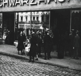
On
March 15, 1933, the Schwarzhaupt couple experienced the cruelty of the
new Nazi regime rulers first-hand when Selz was taken out of bed early
in the morning, kidnapped, abused and shot on Dreifaltigkeitsberg near
Weng. The
Schwarzhaupts soon felt the fanatical anti-Semitism in their business,
too. The photo from 1933 shown right has survived, presumably from April
1, when the Nazis called for a boycott of Jewish shops throughout
Germany, in which SA men can be recognised intimidating prospective
customers in front of the shop door.  According to Geary
(74), "[i]n Straubing Nazi excesses against local Jews ended in murder.
Partly to control such uncoordinated violence, the regime organised a
boycott of Jewish businesses for April 1, 1933, although this seems to
have had little success with the German public at large."
According to Geary
(74), "[i]n Straubing Nazi excesses against local Jews ended in murder.
Partly to control such uncoordinated violence, the regime organised a
boycott of Jewish businesses for April 1, 1933, although this seems to
have had little success with the German public at large."
 According to Geary
(74), "[i]n Straubing Nazi excesses against local Jews ended in murder.
Partly to control such uncoordinated violence, the regime organised a
boycott of Jewish businesses for April 1, 1933, although this seems to
have had little success with the German public at large."
According to Geary
(74), "[i]n Straubing Nazi excesses against local Jews ended in murder.
Partly to control such uncoordinated violence, the regime organised a
boycott of Jewish businesses for April 1, 1933, although this seems to
have had little success with the German public at large."Despite
occasional attempts at intimidation by the Nazis, the population
remained loyal to their well-known department stores by and large.
However, Levite, who had been the sole managing director since 1935,
recognised the threat and in April 1938, the Munich merchant Ludwig
Hafner took over the business; by November 1940, the “Hafner & Co”
company acquired the entire property from Karl Schwarzhaupt, who had
meanwhile moved to Munich with his wife. The actual purchase price was
immediately confiscated by the Nazis. Mohaus Hafner is still in business and openly celebrates having taken over the business eight decades earlier on its webpage (Der Hafner - seit 80 Jahren in Straubing). In mid-October 1941, Karl and his
mother Emma were interned in Munich and finally moved to the barracks
camp on Knorrstrasse. On June 18, 1942, they were deported to the
Theresienstadt ghetto from where Karl Schwarzhaupt died on January 20,
1943 and his mother on March 8, 1944. Granddaughter Lieselotte Levite,
who became Louise when she arrived in the United States, described her
grandparents as "wonderful, good , good people who have never done
anything to anyone!! ... Tears come to our eyes when we think of how
they had to suffer in Theresienstadt, where my grandfather died of
'natural causes' [starved to death]. We learned that my grandmother was
killed in a crematorium in Theresienstadt.”
The
Jewish community's destruction was nearly complete by 1943, with only
three individuals remaining in hiding, aided by local farmer Maria
Huber, who was later executed in 1944 for her actions.

Straubing's
integration into the Nazi war machine intensified after 1939, as the
town became a hub for military logistics and production. The local
airfield, constructed in 1937, was upgraded in 1941 to accommodate
Luftwaffe training units, with 300 pilots stationed there by 1943. The
airfield's expansion displaced 120 farmers, whose land was confiscated
without compensation, a policy emblematic of the regime's disregard for
rural communities. The Straubing prison, repurposed in 1940 as a transit
camp, held 1,500 political prisoners and forced labourers en route to
Dachau, with 200 deaths recorded due to overcrowding by 1944. The
regime's ideological campaigns persisted, with the Hitlerjugend
expanding to 4,200 members in Straubing by 1942, enforcing mandatory
participation for youths aged 10 to 18. Such militarisation of youth
ensured generational loyalty, although there were isolated instances of
non-compliance, such as the 1943 expulsion of 30 boys for refusing to
salute the Nazi flag. The Straubinger Tagblatt continued to shape
public opinion, printing 10,000 copies daily by 1941, with editor
Mueller praising the war effort while censoring reports of local
casualties, which totalled 1,200 Straubing soldiers by 1945. The
regime's grip tightened as the war progressed, with Straubing's
infrastructure increasingly devoted to military efforts. The town's
railway station, expanded in 1940, facilitated the transport of 5,000
troops monthly to the Eastern Front by 1942. Forced labour became
integral, with 2,100 foreign workers, mainly Ukrainians, employed in
local industries by 1944, producing munitions and textiles. Straubing's
economy depended heavily on this exploited workforce, with 30% of local
output tied to military contracts. The human cost was noticeable, such
as the 1943 death of 45 Polish labourers in a factory explosion, which
was suppressed by the Straubinger Tagblatt. The Catholic Church's role
evolved, with Bishop Michael Buchberger of Regensburg, who oversaw
Straubing's diocese, issuing a 1941 pastoral letter urging loyalty to
the state, though privately expressing unease about deportations. By
1945, Straubing's population had swelled to 28,000 due to refugees,
straining resources and exacerbating tensions. The final issue of the
Straubinger Tagblatt, published on 18 April 1945, reported an air raid
that killed 62 civilians, marking the collapse of Nazi authority as
American forces approached. In 1944 and 1945 Straubing suffered from
several American air raids during which time the local military hospital
was destroyed to the extent of eighty percent with a loss of 45
patients. In
three heavy American air raids on the Straubing railroad
at least 400 people were killed, and extensive destruction in the urban
area was established. Most of the historic buildings survived the
bombings undamaged however. By
1945, Straubing's population had risen to 44,000 due to refugees,
straining food supplies to 1,100 daily bread rations. The final Allied
air raid on April 18, 1945, killing 52, marked the regime's collapse, as
American troops entered on April 27, ending Nazi control..gif)
.gif)
On
April 28, 1945 at around noon, the Americans took the city without a
fight after it had been bombed with over 500 tonnes of explosives. On
the afternoon the next day Wallersdorf, an hour away, was peacefully
handed over to the American units.
Straubing had been the target of five air raids, the heaviest of which
occurred on April 18, 1945 when 460 people were killed and 29% of the
buildings were damaged including the Protestant church on Bahnhofstrasse
and the Catholic cemetery church of St. Michael. After the war 14,000
refugees were temporarily housed; by 1950 there were still 6,997
displaced persons out of a population of 36,147. Just ten days later
American tanks arrived from the west via Regensburger Strasse, marking
the end of the war for Straubing. Almost 2,000 its citizens lost their
lives or were missing; around fifty Jewish fellow citizens - half of
Straubing's pre-war community - didn't survive deportation and
concentration camps.
On April 28, 1945 the ϟϟ blew up the Schloßbrücke Straubing over the Danube to retard the allies' advance. It was rebuilt between 1946 and 1949, being inaugurated by Bishop Michael Buchberger on December 27, 1949.

Overlooking
the Danube and towards the bridge is this reichsadler, created by Munich sculptor Fritz Schmoll, also known as Eisenwerth.  He
was commissioned by the Deggendorf cultural building authority to
produce a "sculpture (national eagle) in Danube limestone for the
bastion of the Straubing pumping station at a price of 10,000 RM".
Schmoll carved an eagle that weighed seven tonnes, at 2.90 metres in
height and 1.75 metres in width, signed “FSgE” and the dates “1941/42”.
In 1936, Straubing started building water protection measures with the
help of the Water Management Office, building the pumping station on
Gscheiderbrückl. From 1938, members of the Reich Labour Service,
prisoners of war and Deggendorf workers built the dikes and dams along
the Moosmühlbach and the Danube with the pumping station and the
so-called "Bastion" to form a flood protection wall. After it was
completed in 1940, a so-called "bastion" was built, consisting of a
roundel with a diameter of 12.60 metres. In addition, a high pillar with
a swastika relief and a magnificent Nazi eagle, which was supposed to
show the greatness of the Nazi state, was to be erected on it. However,
since the construction work on the bastion and the pillar had to be
stopped in the middle of the war due to a lack of workers and building
materials and was finally stopped altogether in 1943. The rondel was
already finished, but the granite pillar with a base area of 1.83 by
1.50 metres was only 2.33 metres high. The sculpture survived the war
first in Munich, then in the building yard of the water management
office in Vogelau.
He
was commissioned by the Deggendorf cultural building authority to
produce a "sculpture (national eagle) in Danube limestone for the
bastion of the Straubing pumping station at a price of 10,000 RM".
Schmoll carved an eagle that weighed seven tonnes, at 2.90 metres in
height and 1.75 metres in width, signed “FSgE” and the dates “1941/42”.
In 1936, Straubing started building water protection measures with the
help of the Water Management Office, building the pumping station on
Gscheiderbrückl. From 1938, members of the Reich Labour Service,
prisoners of war and Deggendorf workers built the dikes and dams along
the Moosmühlbach and the Danube with the pumping station and the
so-called "Bastion" to form a flood protection wall. After it was
completed in 1940, a so-called "bastion" was built, consisting of a
roundel with a diameter of 12.60 metres. In addition, a high pillar with
a swastika relief and a magnificent Nazi eagle, which was supposed to
show the greatness of the Nazi state, was to be erected on it. However,
since the construction work on the bastion and the pillar had to be
stopped in the middle of the war due to a lack of workers and building
materials and was finally stopped altogether in 1943. The rondel was
already finished, but the granite pillar with a base area of 1.83 by
1.50 metres was only 2.33 metres high. The sculpture survived the war
first in Munich, then in the building yard of the water management
office in Vogelau.  The figure was only remembered nine years after the end of the war when, on the morning of December 28, 1954, the pillar with the eagle was erected, the swastika removed of course, under the supervision of the then police commandant and- remarkably- the American occupation forces.Police commander Peter Bauer – a social democrat who was dismissed from the city police service in 1933 because of his political views and was appointed chief of police by the Americans at the end of the war – was directly involved in its construction, as were the municipal building department under Franz Xaver Feichtmeyer and the American occupying forces led by Major Cheney Engr. and CWO Lawson who directed departments with German specialists. The heavy blocks of stone were transported from the courtyard of the Water Management Office where they had been stored for years, to the location with a ten-tonne tow truck. A part of the enclosing wall was torn down there to enable the crane to enter the interior of the bastion. With a five-tonne crane on an eight-tonne truck, drivers Karl Biederer and Günther Dünnebier lifted it piece by piece as shown here and, with the assistance of numerous experts, placed it on the podium. After several hours of work, the eagle stood in its intended place and cast its gaze menacingly into the distance, as befits a Nibelung eagle.” The eagle now was described as no longer to be regarded as a Nazi symbol of power, but rather as a "Nibelung eagle" and "stone portrait worth seeing". Nevertheless the bastion with the eagle is not only a lookout point for walkers, but serves to remind of the dark history of Germany through remaining traces of evil.
 He
was commissioned by the Deggendorf cultural building authority to
produce a "sculpture (national eagle) in Danube limestone for the
bastion of the Straubing pumping station at a price of 10,000 RM".
Schmoll carved an eagle that weighed seven tonnes, at 2.90 metres in
height and 1.75 metres in width, signed “FSgE” and the dates “1941/42”.
In 1936, Straubing started building water protection measures with the
help of the Water Management Office, building the pumping station on
Gscheiderbrückl. From 1938, members of the Reich Labour Service,
prisoners of war and Deggendorf workers built the dikes and dams along
the Moosmühlbach and the Danube with the pumping station and the
so-called "Bastion" to form a flood protection wall. After it was
completed in 1940, a so-called "bastion" was built, consisting of a
roundel with a diameter of 12.60 metres. In addition, a high pillar with
a swastika relief and a magnificent Nazi eagle, which was supposed to
show the greatness of the Nazi state, was to be erected on it. However,
since the construction work on the bastion and the pillar had to be
stopped in the middle of the war due to a lack of workers and building
materials and was finally stopped altogether in 1943. The rondel was
already finished, but the granite pillar with a base area of 1.83 by
1.50 metres was only 2.33 metres high. The sculpture survived the war
first in Munich, then in the building yard of the water management
office in Vogelau.
He
was commissioned by the Deggendorf cultural building authority to
produce a "sculpture (national eagle) in Danube limestone for the
bastion of the Straubing pumping station at a price of 10,000 RM".
Schmoll carved an eagle that weighed seven tonnes, at 2.90 metres in
height and 1.75 metres in width, signed “FSgE” and the dates “1941/42”.
In 1936, Straubing started building water protection measures with the
help of the Water Management Office, building the pumping station on
Gscheiderbrückl. From 1938, members of the Reich Labour Service,
prisoners of war and Deggendorf workers built the dikes and dams along
the Moosmühlbach and the Danube with the pumping station and the
so-called "Bastion" to form a flood protection wall. After it was
completed in 1940, a so-called "bastion" was built, consisting of a
roundel with a diameter of 12.60 metres. In addition, a high pillar with
a swastika relief and a magnificent Nazi eagle, which was supposed to
show the greatness of the Nazi state, was to be erected on it. However,
since the construction work on the bastion and the pillar had to be
stopped in the middle of the war due to a lack of workers and building
materials and was finally stopped altogether in 1943. The rondel was
already finished, but the granite pillar with a base area of 1.83 by
1.50 metres was only 2.33 metres high. The sculpture survived the war
first in Munich, then in the building yard of the water management
office in Vogelau.  The figure was only remembered nine years after the end of the war when, on the morning of December 28, 1954, the pillar with the eagle was erected, the swastika removed of course, under the supervision of the then police commandant and- remarkably- the American occupation forces.Police commander Peter Bauer – a social democrat who was dismissed from the city police service in 1933 because of his political views and was appointed chief of police by the Americans at the end of the war – was directly involved in its construction, as were the municipal building department under Franz Xaver Feichtmeyer and the American occupying forces led by Major Cheney Engr. and CWO Lawson who directed departments with German specialists. The heavy blocks of stone were transported from the courtyard of the Water Management Office where they had been stored for years, to the location with a ten-tonne tow truck. A part of the enclosing wall was torn down there to enable the crane to enter the interior of the bastion. With a five-tonne crane on an eight-tonne truck, drivers Karl Biederer and Günther Dünnebier lifted it piece by piece as shown here and, with the assistance of numerous experts, placed it on the podium. After several hours of work, the eagle stood in its intended place and cast its gaze menacingly into the distance, as befits a Nibelung eagle.” The eagle now was described as no longer to be regarded as a Nazi symbol of power, but rather as a "Nibelung eagle" and "stone portrait worth seeing". Nevertheless the bastion with the eagle is not only a lookout point for walkers, but serves to remind of the dark history of Germany through remaining traces of evil.
 .jpg)
Standing behind the monument with the limestone relief directly behind me depicting a ploughing farmer inscribed with "1941" by the Munich artist Johann Peter Vogl (or Hans Vogl).
 Nearby
is the so-called Agnes-Bernauer-Turm, seen here in a Nazi-era postcard
from 1941 and today. It was a fortified tower making up the city
fortifications, probably built in 1477 and attached to the city wall to
the east and south. The tower is named after Agnes Bernauer, the
mistress and perhaps also the first wife of the Bavarian Duke Albrecht
III. This connection, which did not befit his status, brought Albrecht
into conflict with his father, Duke Ernst of Bavaria-Munich, who had
Agnes Bernauer drowned in the Danube in 1435. In the 19th century the
legend spread that Bernauer was imprisoned in this tower resulting in
its depiction in numerous engravings and lithographs, on postcards and
posters. On the 500th anniversary of Bernauer's death in 1935, the local
Nazi district culture warden Eugen Hubrich, who had already written
open -air plays for the Further Drachenstich and the 900th anniversary
of the city of Amberg, wrote Die Agnes Bernauerin zu Straubing.
Hubrich, according to his own statements was"a National Socialist out of
idealism [...] but also with enthusiasm," not only wanted to boost
tourism with his piece, but also do justice to the Nazi concept of art.
He described his intention in the style of the time: "The
great-great-grandchildren should feel as their ancestors felt in the
same place, but they should also recognise that Agnes was a people's
sacrifice that was devoured by the cruel Middle Ages, but that can rise
again in purity in the happy time that brings about the renewal of the
blood and morals of the people from the primal source of life.”
Nearby
is the so-called Agnes-Bernauer-Turm, seen here in a Nazi-era postcard
from 1941 and today. It was a fortified tower making up the city
fortifications, probably built in 1477 and attached to the city wall to
the east and south. The tower is named after Agnes Bernauer, the
mistress and perhaps also the first wife of the Bavarian Duke Albrecht
III. This connection, which did not befit his status, brought Albrecht
into conflict with his father, Duke Ernst of Bavaria-Munich, who had
Agnes Bernauer drowned in the Danube in 1435. In the 19th century the
legend spread that Bernauer was imprisoned in this tower resulting in
its depiction in numerous engravings and lithographs, on postcards and
posters. On the 500th anniversary of Bernauer's death in 1935, the local
Nazi district culture warden Eugen Hubrich, who had already written
open -air plays for the Further Drachenstich and the 900th anniversary
of the city of Amberg, wrote Die Agnes Bernauerin zu Straubing.
Hubrich, according to his own statements was"a National Socialist out of
idealism [...] but also with enthusiasm," not only wanted to boost
tourism with his piece, but also do justice to the Nazi concept of art.
He described his intention in the style of the time: "The
great-great-grandchildren should feel as their ancestors felt in the
same place, but they should also recognise that Agnes was a people's
sacrifice that was devoured by the cruel Middle Ages, but that can rise
again in purity in the happy time that brings about the renewal of the
blood and morals of the people from the primal source of life.”


What
is now the Amtsgericht (District Court) Straubing on Kolbstrasse 11. In
February 1997, this courthouse tried a young man from Saxony whom the
public prosecutor accused of wearing a triangle-shaped fabric patch on
the left sleeve of his denim jacket at a neo-Nazi NPD rally, which is
confusingly similar to the Obergauarmdreieck of the BdM, a banned Nazi
organisation, and which is thus guilty of a misuse of the symbols of
unconstitutional organisations according to § 86a of the criminal code.
The district court acquitted the defendants, whereupon the public
prosecutor appealed to the Bavarian Supreme Court because of the
fundamental importance of the case. Its 2nd criminal senate overturned
the judgement and referred the case back to the district court for a new
trial by another criminal judge. As a precautionary measure, the Senate
pointed out the following for this procedure: “[s]hould the district
court find that the patch worn by the defendant was in the shape of a
black triangle with a gold-coloured border and the gold-coloured
lettering 'Sachsen', it can hardly be denied that this patch looks
confusingly similar to the upper arm triangle of the Hitler Youth [...]
".

The
Senate referred to an expert opinion by the Institute for Contemporary
History and to a panel in the "Organisation Book of the NSDAP". Because
Section 86a (2) sentence 2 of the Criminal Code only requires that the
markings used can be confused with the originals. In other words, the
badge is confusingly similar to the original "if an impartial person can
easily regard it as the mark of an unconstitutional organisation [...].
whether the appearance of a mark of the respective organisation is
created and its symbolic content is conveyed [...]. " Eventually the
local court found the accused guilty based on an expert opinion by the
Institute for Contemporary History only for the 5th Criminal Senate of
the Bavarian Supreme Court to overturn the judgement and acquit the
defendant on December 7, 1998.
 Just outside the town centre west of the Ostenfeld was the Roman vicus known as Sorviodurum in antiquity, a significant civilian settlement in the Roman province of Raetia, located along the Danube River. This settlement, tied to a military fort, flourished from the 1st to the 4th centuries AD, serving as a hub for trade, craftsmanship, and cultural interaction between Roman settlers and local populations. Its history reflects the broader dynamics of Roman frontier life, and its archaeological remains offer a glimpse into this vibrant past. This fort was part of the Limes Germanicus, Rome's fortified northern frontier, designed to secure the empire against Germanic tribes. The vicus developed organically to support the fort's garrison, attracting merchants, craftsmen, veterans, and locals seeking economic opportunities. By the early 2nd century, under the emperor Trajan, the settlement expanded as Raetia's infrastructure grew, benefiting from its strategic position on the Danube, a major trade and military route. The vicus thrived through the 2nd and 3rd centuries, reaching its peak during the Antonine and Severan dynasties, when Roman control over the region was stable. Excavations, particularly in the 19th and 20th centuries, have revealed foundations of timber and stone buildings, including houses, workshops, and small shrines. The settlement likely housed several hundred people, with evidence of pottery kilns, metalworking, and textile production pointing to a diverse economy. Inscriptions and artefacts, such as coins and imported goods like Samian ware, suggest trade links with other parts of the empire. A notable find is a dedication stone to the goddess Fortuna, indicating religious practices typical of Roman civilian life.
 .gif) On the right is a copy of the grave found in Augsburg in 1973 reading "Pompeianius / Silvinus vivus / fecit sibi et / Pomp(eianio) Victori / fratri piissimo / qui vixit annis" (Pompeianius Silvinus erected (the tomb) during his lifetime for himself and his most dutiful brother, Pompeianius Victor, who lived to be 30 years old.) Both men were certainly natives of Raetia or the neighbouring Celtic region with a pseudo-Roman name ('Pompeianius' instead of 'Pompeianus'). Based on the depictions on either side which are still remarkably preserved, it's assumed both worked a wine merchant and innkeeper respectively. The depicted basketwork indicates South Gallic wine amphorae, which the brothers presumably used to import Gallic or Italian wine. One can compare the copy with how it appears today in Heidelberg. The vicus also of course featured a bathhouse.By the mid-3rd century, pressures from Germanic tribes, particularly the Alemanni, began to destabilise the region. The vicus faced decline as raids increased, and by the late 4th century, Roman control over Raetia weakened. The settlement was likely abandoned by the early 5th century as the empire's frontiers collapsed. Some evidence suggests partial destruction by fire, possibly during raids, though natural decay also played a role. Today, little of the vicus remains visible above ground due to Straubing's modern development although the Gäubodenmuseum in Straubing houses many artefacts from the vicus, including pottery, tools, and inscriptions. Notable exhibits include a reconstructed Roman shield and jewellery, offering insights into daily life.
On the right is a copy of the grave found in Augsburg in 1973 reading "Pompeianius / Silvinus vivus / fecit sibi et / Pomp(eianio) Victori / fratri piissimo / qui vixit annis" (Pompeianius Silvinus erected (the tomb) during his lifetime for himself and his most dutiful brother, Pompeianius Victor, who lived to be 30 years old.) Both men were certainly natives of Raetia or the neighbouring Celtic region with a pseudo-Roman name ('Pompeianius' instead of 'Pompeianus'). Based on the depictions on either side which are still remarkably preserved, it's assumed both worked a wine merchant and innkeeper respectively. The depicted basketwork indicates South Gallic wine amphorae, which the brothers presumably used to import Gallic or Italian wine. One can compare the copy with how it appears today in Heidelberg. The vicus also of course featured a bathhouse.By the mid-3rd century, pressures from Germanic tribes, particularly the Alemanni, began to destabilise the region. The vicus faced decline as raids increased, and by the late 4th century, Roman control over Raetia weakened. The settlement was likely abandoned by the early 5th century as the empire's frontiers collapsed. Some evidence suggests partial destruction by fire, possibly during raids, though natural decay also played a role. Today, little of the vicus remains visible above ground due to Straubing's modern development although the Gäubodenmuseum in Straubing houses many artefacts from the vicus, including pottery, tools, and inscriptions. Notable exhibits include a reconstructed Roman shield and jewellery, offering insights into daily life. Passau: Hitler's Manufactured Passau Childhood Narrative, and the Mauthausen Subcamps' Industrialised Dehumanisation

Passau, situated at the confluence of the Danube, Inn, and Ilz rivers, became enmeshed in the Nazi movement earlier than most comparable Bavarian cities due to its geographical position on the Austrian border and its biographical connection to Hitler. His father Alois, a customs official in the Austro-Hungarian service, transferred to the German side of the border in 1892, and the family took up residence at Theresienstrasse 23 in Passau, remaining until 1895. The young Hitler attended a local school and absorbed the Lower Bavarian dialect that replaced his native Upper Austrian speech patterns, a linguistic shift that was later noted by early associates including August Kubizek, who remarked upon it in his 1953 memoir. This period in Passau was brief but became a significant element in the mythology the Nazi Party constructed around its leader's formative years. The city archives mention Hitler being in Passau on four different
occasions in the 1920s for speeches.
Hitler mentions it on the first page of Mein Kampf:
my father had to leave that frontier town which I had come to love so much and take up a new post farther down the Inn valley, at Passau, therefore actually in Germany itself.Passau's coat of arms features the rampant red wolf. During the Renaissance Passau had been one of the most prolific centres of sword and bladed weapon manufacture in Germany and Passau smiths stamped their blades with the Passau wolf, usually a rather simplified rendering of the wolf on the city's coat-of-arms. Superstitious warriors believed that the Passau wolf conferred invulnerability on the blade's bearer, and thus Passau swords acquired a great premium. According to Nick Thorpe in his book The Danube, A Journey Upriver from the Black Sea to the Black Forest, this ended up being significant to Hitler's, and the Nazis', development:
‘The Nazis were constantly invoking dogs and wolves as models for the qualities they wanted to cultivate: loyalty, hierarchy, fierceness, courage, obedience, and sometimes even cruelty. Hitler’s code name was “the wolf ”.’ He was also fond of telling people how his name stemmed from the Old High German words – adal – meaning ‘noble’, and wolf...
There is little doubt that the symbolic wolf of Passau made its mark on the young boy’s imagination. ‘For the cult of the wolf seemed to offer the Nazis a promise of the discipline sometimes associated with “civilisation” without its accompanying decadence. Of nature without anarchy. As an animal which had been extinct within Germany for almost a century yet lived on in figures of speech, folk tales and iconography, the wolf suggested a sort of primeval vitality that had been lost.’(249-50)

 On
April 10, 1934, the Passau city council decided to rename the street to Klara-Hitler-Straße after Hitler's mother Klara in memory of the
family's residence at Kapuzinerstraße 31 (today number 5) from 1893 to
1894. It's the red building shown in the background. On April 12, 1938,
the eastern part of the street was renamed General Alfred Kraußstraße.
After the end of the war, the street was given its former name again.
On
April 10, 1934, the Passau city council decided to rename the street to Klara-Hitler-Straße after Hitler's mother Klara in memory of the
family's residence at Kapuzinerstraße 31 (today number 5) from 1893 to
1894. It's the red building shown in the background. On April 12, 1938,
the eastern part of the street was renamed General Alfred Kraußstraße.
After the end of the war, the street was given its former name again.
Hitler nearly drowned when he was four
years-old but was saved by a local priest, historians have claimed.
Newspaper clippings have emerged detailing how a child – who experts
believe was Hitler – was rescued from a river in Passau, Germany,
in January 1894. The infant is not named in the article, which was
uncovered in a German archive, but it matches a story recounted by priest Max Tremmel in 1980. He said his predecessor Johann Kuehberger
told him he had rescued Hitler when the Nazi leader was a child.
Residents of Passau, where Hitler grew up, also claimed the priest's
story was true. The account of the incident remained uncorroborated
until recently when the article emerged. The Donauzeitung-Danube
newspaper described how "a young fellow" was pulled out of the River
Passau by a "brave comrade" after he fell through thin ice. The priest
is said to have dived into the icy water after spotting the child
struggling to stay afloat in the strong current.
Anna Elisabeth Rosmus, a German author who lived in Passau, said the tale was known by most people in the town in book Out of Passau, Leaving a City Hitler Called Home. "Everyone
in Passau knew the story. Some of the other stories told about him were
that he never learned to swim and needed glasses," she wrote. "In 1894,
while playing tag with a group of other children, the way many children
do in Passau to this day, Adolf fell into the river. The current was
very strong and the water ice cold, flowing as it did straight from the
mountains. Luckily for young Adolf, the son of the owner of the house
where he lived was able to pull him out in time and so saved his life."
Hitler told his generals that he used to play cowboys and Indians
on the banks of the river but never admitted to falling in the water. Hitler lived here at Theresienstrasse 23 until May 1, 1893 before his family moved across to the other side of the Inn. This residence later became a site of minor pilgrimage for Nazi supporters during the Third Reich, with German tourists visiting the unremarkable house between 1933 and 1945.
 [Hitler's father's] life revolved around the usual quarters very much: the Customs station at the river bank, the inns, and the bee hives that were his hobby since childhood. He continued his work in good standing and was promoted again in 1892, when Adolf was 3 years old. The family moved to his next duty station, Passau, fifty miles downriver. This change of residence was to exert a significant influence upon young Hitler. Braunau was a provincial, sleepy border town, which had only provided a tiny footnote to German history... The former Imperial town and Episcopal see Passau was of a different calibre. In the Middle Ages, the Prince- Bishop of Passau had ruled over the important market, bishopric and county at the confluence of the Inn and Danube rivers; splendid churches, castles and palaces bore witness to the glory days of the town.Although Passau was on the German bank of the river and border, the Austrian Customs inspection was located, by mutual disposition of the respective governments, on German territory, where, luckily, the inns closed an hour later at night. Yet for the family in general, and Alois in particular, the change of posting seems not to have been entirely welcome. Alois had lived seventeen years in Braunau, where he had buried two wives, and had developed affection for the small town. There was also the fact that in Braunau he was necessarily a bigger fish than in the much larger Customs office in Passau, and, in addition, the position in Passau was a provisional appointment only, subject to confirmation by his superiors.
It was perhaps only for the youngest member of the family, Adolf, three and a half years old, that the new town was an unmitigated success; he was in the impressionable age in which a child leaves home for the first time and is unfailingly altered by the first impressions of the new environment, the sight of the buildings, the sound of the language. For the rest of his life, Adolf Hitler would speak the distinctive dialect of Lower Bavaria that was spoken in Passau. He insisted later that, from his time in Passau onwards, he had always felt more German than Austrian, and the old town's cultural and historic pedigree certainly provided a different impression than sleepy Braunau. In all probability, he spent two carefree years in Passau.John Vincent Palatine (172) Children of the Lesser Men


Of Hitler's accent, it has been described as being that from Passau. According to Keller 2010 (15), "He played a lot with the neighbourhood children, and through them came in contact with the Lower Bavarian dialect, which he retained for the rest of his life. Hamann 2010 (7-8) describes how "[b]etween 1892 and 1895 Alois went to work in Passau, on the German side of the border, during which time the three- to six-year-old boy acquired his peculiar Bavarian accent: The German of my youth was the dialect of Lower Bavaria; I could neither forget it nor learn the Viennese jargon." Hitler's childhood friend Kubizek 2006 (37) recalled how "[h]e disliked dialect, in particular Viennese, the soft melodiousness of which was utterly repulsive to him. To be sure, Hitler did not speak Austrian in the true sense. It was rather that in his diction, especially in the rhythm of his speech, there was something Bavarian. Perhaps this was due to the fact that from his third to his sixth year, the real formative years for speech, he lived in Passau, where his father was then a customs official."
 On
November 8, 1918, a council of soldiers and workers was formed. In the
course of this, a 200-strong civil service was established, which sought
to preserve public order in the city. The situation was peaceful after
the revolution until the murder of Kurt Eisner in Munich on February 21,
1919 led to the destabilisation of the situation as censorship was
enforced and public meetings were prohibited. On April 7, 1919, the
Soviet republic was established in Passau. Hitler had come to Passau on on February 19, 1920
to found the local branch of the Nazi Party. group in Passau are
described. Hitler delivered what had been described as a "patriotic
lecture, which was greeted with enthusiastic applause, in which the
speaker spoke in convincing, haunted words about the external and
internal causes of our collapse and the unsuitable means to combat the
hardship of our day through phrases and key words."
On
November 8, 1918, a council of soldiers and workers was formed. In the
course of this, a 200-strong civil service was established, which sought
to preserve public order in the city. The situation was peaceful after
the revolution until the murder of Kurt Eisner in Munich on February 21,
1919 led to the destabilisation of the situation as censorship was
enforced and public meetings were prohibited. On April 7, 1919, the
Soviet republic was established in Passau. Hitler had come to Passau on on February 19, 1920
to found the local branch of the Nazi Party. group in Passau are
described. Hitler delivered what had been described as a "patriotic
lecture, which was greeted with enthusiastic applause, in which the
speaker spoke in convincing, haunted words about the external and
internal causes of our collapse and the unsuitable means to combat the
hardship of our day through phrases and key words."  Nazis marching down the Rindermarkt June 17, 1923 in front of what is now the Hotel Passauer Wolf during their first major appearance in Passau. They celebrated 'German Day' and marched with the ϟϟ
bodyguard from Munich from the cathedral to the Schmerold-keller. There
Gregor Strasser handed the standard over to the Passau flag bearer. Hermann Göring was present and Hitler spoke.
Nazis marching down the Rindermarkt June 17, 1923 in front of what is now the Hotel Passauer Wolf during their first major appearance in Passau. They celebrated 'German Day' and marched with the ϟϟ
bodyguard from Munich from the cathedral to the Schmerold-keller. There
Gregor Strasser handed the standard over to the Passau flag bearer. Hermann Göring was present and Hitler spoke. On October 27, 1923, Hitler returned to give a speech at the Nibelungenhalle. This speech marked a turning point in spreading his political views in the region and contributing to the future consolidation of Nazi power.
Just over a fortnight later would see the failed Beer Hall putsch in Munich after which several party members from Passau were arrested and the party itself banned. However, it quickly reformed itself, camouflaging itself first in the GesangsvereinEinigkeit, a choral group, in the shooting and hiking association, in the front fighters association and finally in the Deutschvölkischen Turnverein Jahn, a gymnastics organisation. On March 5, Max Barnerssoi chaired the party's refounding. Shortly before the ban was lifted on February 14, 1925, Himmler from nearby Landshut visited the Passau branch members. Himmler had been the most frequent leading Nazi official to visit Passau, having had a personal connection to the town- his father Gebhard Himmler had served as an high school professor at Passau Humanistic High School from 1902 to 1904. Himmler ended up speaking in Passau on May 10, 1926, August 20, 1926, March 26, 1927, July 8, 1927, October 29, 1927, April 21 1928, February 8, 1930, April 17, 1931 and March 7, 1932. Other prominent speakers included Hans Schemm, Gauleiter and Bavarian Minister of Culture, on February 6, 1929. Julius Streicher, Gauleiter Franken and founder of the notorious "Der Stürmer" spoke on May 27, 1929, about the "Judaism of German Justice". Streicher organised the first boycott of Jews in 1933 on Hitler's behalf. Gregor Strasser, whom Hitler later had shot during the Rohm Putsch on June 30, 1934, spoke on February 25, 1928, on September 24, 1929, and on September 7, 1930 in the Dreiflüssestadt. Propaganda leader Hermann Esser came on October 5, 1929, and on March 1, 1932. Wilhelm Frick, the later Minister of the Interior who would also become the driving force in the drafting of the Nuremberg Laws spoke as well, although such speaking events were not always very well attended.
 The city's position directly opposite the Austrian town of Schaerding on the Inn River made it the primary transit point for Nazi propaganda entering Austria during the late 1920s and early 1930s. The Austrian government banned the Nazi Party in June 1933, but couriers operating from Passau smuggled the People's Observer newspaper, pamphlets, and organisational directives across the river using small boats, hidden compartments in commercial vehicles, and sympathetic customs officials. Theodor Habicht, the Nazi Party's inspector for Austria appointed by Hitler in 1932, coordinated much of this operation from Munich but relied heavily on the Passau network for the physical transfer of materials. The Passau police, by this point thoroughly infiltrated by Nazi sympathisers, rarely interfered with these smuggling operations.
 Soon after Hitler came to power, the democratic parties were pushed out of the city council in Passau so that when appointed on April 27, 1933 it only had nine BVB representatives and eleven Nazis. The number of city councillors had been arbitrarily reduced from 30 to twenty. Max Moosbauer replaced the former Mayor Dr. Carl Sittler. The Passau SPD dissolved on April 8. After April 20, 1933, the "Führer's Birthday", Hitler Youth and BdM moved to Kapuzinerstrasse 5 and hoisted the swastika flag on Hitler's former home at Theresienstrasse 23. Hitler became an honorary citizen of Passau on March 14, 1933; Hitler never received it, but the document is still in the city archives.
On April 27, 1933 Ludwigsplatz became Adolf-Hitler-Platz. This was also where the Nazi Party headquarters, the "Braune Haus", was located. Sedanstraße became Ritter von Epp-Straße "(today renamed Neuburgerstraße). Nikolastraße became Hans Schemm-Straße, Mühltal became Horst-Wessel-Straße and Schmiedgasse/Kapuzinerstraße renamed Klara-Hitler-Straße.
.gif)
The Nazis would set up the Kinderlandverschickung (KLV), a programme established by during the war to evacuate children from cities at risk of Allied bombing. In Passau, one of the major reception areas, the programme started operating in 1940. A considerable number of children, estimated to be in the thousands, were relocated to Passau during the programme's operation from 1940 to 1945. The children were housed in numerous camps and accommodations around Passau, its main camp located in the Passau district of Heining. Living conditions in the camps varied, but many children, particularly those in the latter years of the war, faced food shortages and inadequate medical care, reflecting the overall scarcity of resources within Germany. The programme in Passau was overseen by local party officials of the Nazi regime, including the local Kreisleiter. They were responsible for the administration and supervision of the camps. The children's daily life was strictly regimented in line with Nazi ideology with the aim not only to protect the children but also to indoctrinate them. Thus, a key part of their daily routine was attending lessons, which included Nazi propaganda. As the war neared its end and the Allied forces advanced, the programme in Passau was terminated in April 1945, and the remaining children were returned to their homes.
.gif) Himmler had also spent time in Passau during the 1920s, engaging in early party activities. Specific details of his visits are scarce, but city records confirm his presence at a 1922 nationalist rally, where he spoke to a crowd of about 150, advocating for a unified German-Austrian state. His activities in Passau were part of his early organisational work for the Nazi Party, which Kershaw describes as foundational to his later role in the ϟϟ. The city’s role as a hub for nationalist sentiment was further evidenced by the construction of the Nibelungenhalle, announced in November 1933. Designed to hold 8,000 to 10,000 people, with space for an additional 30,000 outside, the hall was completed in 1935 and served as a venue for Nazi gatherings. It also housed a unit of the Austrian Legion, a paramilitary group of Austrian Nazis who fled to Germany after the 1934 assassination of Austrian Chancellor Engelbert Dollfuss. The hall’s construction reflected Passau’s integration into the Nazi cultural apparatus, with its name invoking Germanic mythology, a theme central to Nazi propaganda. In Passau, the hall’s construction was met with mixed reactions, with some residents, according to Rosmus, resenting the imposition of external Nazi symbolism. The city’s economic life, traditionally tied to the Inn River salt trade and blade manufacturing, was repurposed to support Nazi militarisation, with local factories producing components for the Wehrmacht by 1939, employing approximately 1,200 workers, according to municipal records. The Passau wolf, a mediæval symbol stamped on blades, was co-opted by Nazi propaganda to signify invulnerability.
Himmler had also spent time in Passau during the 1920s, engaging in early party activities. Specific details of his visits are scarce, but city records confirm his presence at a 1922 nationalist rally, where he spoke to a crowd of about 150, advocating for a unified German-Austrian state. His activities in Passau were part of his early organisational work for the Nazi Party, which Kershaw describes as foundational to his later role in the ϟϟ. The city’s role as a hub for nationalist sentiment was further evidenced by the construction of the Nibelungenhalle, announced in November 1933. Designed to hold 8,000 to 10,000 people, with space for an additional 30,000 outside, the hall was completed in 1935 and served as a venue for Nazi gatherings. It also housed a unit of the Austrian Legion, a paramilitary group of Austrian Nazis who fled to Germany after the 1934 assassination of Austrian Chancellor Engelbert Dollfuss. The hall’s construction reflected Passau’s integration into the Nazi cultural apparatus, with its name invoking Germanic mythology, a theme central to Nazi propaganda. In Passau, the hall’s construction was met with mixed reactions, with some residents, according to Rosmus, resenting the imposition of external Nazi symbolism. The city’s economic life, traditionally tied to the Inn River salt trade and blade manufacturing, was repurposed to support Nazi militarisation, with local factories producing components for the Wehrmacht by 1939, employing approximately 1,200 workers, according to municipal records. The Passau wolf, a mediæval symbol stamped on blades, was co-opted by Nazi propaganda to signify invulnerability.
.gif)
The Nazis also set
up a Thingplatz. There were also plans for a an Ehrenmal
Großdeutschland to express the importance of the movement here. Recently
it was discovered within the town's archives love letters written to
Hitler which had been collected in Passau and not passed on to the
Führer. Other aspects of Nazi rule which had remained undetected in the
city archive for the past decade include material about those deemed
mentally ill, and still waiting to be processed are the files of people
who found themselves in trouble due to non-conformity.
Lacking
is information about the two concentration camp subcamps in
Oberilzmühle and Grubweg, or the role of the church in Passau.
 |
| Residenzplatz |
When the Nazis launched their economic boycott upon taking power in 1933, it hit the twelve Jewish shops hard. When the Jewish department store Merkur
wanted to hold its annual sale in August 1935 for example, Nazi
officials prevented buyers from entering the store. Eventually the
police closed the department store. On August 31, 1935, a well-attended
anti-Semitic rally took place in Passau as on that night and in the
following days, anti-Jewish posters and slogans were stuck on the
windows of the Jewish shops and anti-Semitic leaflets were distributed.
Within a short time, all Jewish businesses became 'aryanised'. By then, Passau’s Jewish population, which had numbered around 200 in
1933, had dwindled to fewer than fifty due to emigration and early Nazi
persecution, as documented in synagogue records. The synagogue itself,
located on Schustergasse, was vandalised during Kristallnacht in
November 1938, with its Torah scrolls destroyed, according to a 1938
police report. Rosmus details how local authorities downplayed the
event, claiming minimal damage, though survivor testimonies contradict
this, describing widespread looting. This discrepancy highlights what
Evans calls the “systematic distortion” of local records under Nazi
control. Passau’s Jewish community, small but historically significant
since the 10th century, faced increasing marginalisation, with
businesses boycotted as early as April 1933, in line with national Nazi
policies. In August
1938 Robert Weilheimer was arrested and taken to Amberg prison later to
be murdered in Treblinka. By the time the deportations began, almost
all Jewish residents had emigrated or moved from Passau with twenty to
Munich and another four to Berlin. The last two Jewish residents were
women who lived in "privileged mixed marriage" and survived the war.
 |
| In front of the Wittelsbacherbrunnen |
After
1945, a Jewish community of former concentration camp prisoners and
displaced persons (mainly from Kielce in Poland) were settled in Passau
and by January 1946 a Jewish community was founded. In August 1946 there
were 150 Jews living in the city with the administrative seat and
cultural centre of the Jewish community under community chairman Josef Holländer established inside the Hotel Deutscher Kaiser
at Bahnhofstrasse 30. The number of Jews temporarily housed in
apartments or houses in Passau grew to about 280 people, most of whom
eventually moved to the new state of Israel in 1948. Before emigrating,
many had prepared in a "training kibbutz" in Soldenpeterweg 19. In 1961
there were still 35 Jewish residents; this was reduced to a mere twenty
by 1976.
In November 1933, the building of Nibelungenhalle was announced. Intended to hold 8,000 to 10,000 guests, and another 30,000 in front of it, in 1935 the hall also became quarters for a unit of the Austrian Legion. At the start of 1934, these troops had occupied a building that belonged to Sigmund Mandl, a Jewish merchant. That building, in turn, was referred to as SA barracks. Beginning in 1940, Passau offered the building at Bräugasse 13 to Volksdeutsche Mittelstelle.
In November 1933, the building of Nibelungenhalle was announced. Intended to hold 8,000 to 10,000 guests, and another 30,000 in front of it, in 1935 the hall also became quarters for a unit of the Austrian Legion. At the start of 1934, these troops had occupied a building that belonged to Sigmund Mandl, a Jewish merchant. That building, in turn, was referred to as SA barracks. Beginning in 1940, Passau offered the building at Bräugasse 13 to Volksdeutsche Mittelstelle.
 During the war, the city's industrial output was redirected to military production. The Kohlbacher engineering works produced components for military vehicles, and smaller workshops manufactured ammunition casings and field equipment. A subcamp of the Mauthausen concentration camp system was established at Passau-Oberilzmühle in 1942, holding between 200 and 300 prisoners at any given time. These inmates, drawn primarily from Poland, the Soviet Union, and France, were forced to perform construction labour and quarry work under ϟϟ guard. Mortality was high, with deaths recorded from exhaustion, malnutrition, typhus, and direct violence by guards. A second forced labour installation operated at Waldwerke Passau, where prisoners manufactured prefabricated wooden components for military barracks. In 1942, an external warehouse of the Dachau concentration camp was
located in Passau. The prisoners were used in the construction of an
underwater power station at the present lake lake Oberilzmühle. From
November 1942 onwards, this external camp was transferred to the
Mauthausen concentration camp, which opened Passau II in March 1944, and
Passau III in March 1945. The prisoners were here in the Waldwerke
Passau-Ilzstadt and at the Bayer.
During the war, the city's industrial output was redirected to military production. The Kohlbacher engineering works produced components for military vehicles, and smaller workshops manufactured ammunition casings and field equipment. A subcamp of the Mauthausen concentration camp system was established at Passau-Oberilzmühle in 1942, holding between 200 and 300 prisoners at any given time. These inmates, drawn primarily from Poland, the Soviet Union, and France, were forced to perform construction labour and quarry work under ϟϟ guard. Mortality was high, with deaths recorded from exhaustion, malnutrition, typhus, and direct violence by guards. A second forced labour installation operated at Waldwerke Passau, where prisoners manufactured prefabricated wooden components for military barracks. In 1942, an external warehouse of the Dachau concentration camp was
located in Passau. The prisoners were used in the construction of an
underwater power station at the present lake lake Oberilzmühle. From
November 1942 onwards, this external camp was transferred to the
Mauthausen concentration camp, which opened Passau II in March 1944, and
Passau III in March 1945. The prisoners were here in the Waldwerke
Passau-Ilzstadt and at the Bayer. During the war the town also housed three sub-camps of the infamous Mauthausen-Gusen concentration camp: Passau I (Oberilzmühle), Passau II (Waldwerke Passau-Ilzstadt) and Passau III (Jandelsbrunn).
In
addition to working on construction sites, the prisoners were also used
to dig up unexploded ordnance after the bombing of Passau during the
war. The Passau population called the prisoners "zebra people" because of their striped clothing.
In his history of the Mauthausen concentration camp, Hans Marsalek
wrote that the highest prisoner population was 333 people. They had been
housed in a barrack surrounded by barbed wire and forced to work in two
shifts in the forest works for the manufacture of Tiger gearboxes
-Panzer, and the production of steel bunker doors and the introduction
of steel bunker doors and individual parts for aircraft construction.
Prisoner transports of 100 to 150 men to the Mauthausen and Flossenburg
camps had been made several times.
On
May 3, 1945, a message from Major General Stanley Eric Reinhart’s 261st
Infantry Regiment stated at 3:15 am: "AMG Officer has unconditional
surrender of PASSAU signed by Burgermeister, Chief of Police and Lt. Col
of Med Corps there. All troops are to turn themselves in this
morning." It was the site of a post-war American sector DP camp. 
On
the day Hitler finally killed himself, the Kaiserin-Elisabeth-Brücke
was blown up, since rebuilt. The city of Passau was bombed three times
in the final phase of the war, with a total of about 200
fatalities and the destruction of almost 250 buildings. The main target
of the attacks was the railway station. After the American Army advanced
in the spring of 1945 through Bavaria to the east, a larger defence
operation was planned for the city of Passau by the German armed forces.
However, only small-scale combat operations took place, and finally, on
May 2, 1945, the city was handed over to the units of the American armed
forces by the former mayor Carl Sittler. The next day Captain
John Baumgartner of the American 11th Armoured Division accepted the surrender of the city, marking the end of the Nazi regime's control over
Passau. As early as January 1945, the
city and the surrounding countryside from Passau were the target of
refugees from Silesia who reached Passau with horse carts and
overcrowded trains. Towards the end of the war and in the
immediate post-war period the arrival of German-born refugees from
Bohemia took place. In September 1945 there were over 28,000 refugees
and displaced persons in the city. Due to the lack of housing, numerous
provisional barrack settlements were built in the urban area. In the immediate aftermath, Passau became one of the most significant displaced persons transit points in the American occupation zone, with tens of thousands of refugees from Austria, Czechoslovakia, Hungary, and the Balkans passing through the city between 1945 and 1948. The denazification tribunals in Passau processed hundreds of cases but, as across much of Bavaria, the outcomes were inconsistent, with many former party members classified as followers rather than offenders and reintegrated into civic life within a few years.

The
208 metre long Luitpoldbrücke on the right, colloquially known as the
Hängebrücke, in 1938 and its current incarnation during my 2020 cycling
trip. Shortly before the end of the war on May 2, 1945, just before the
invasion of American troops, the bridge was partially blown up. Only the
two concrete pylons in front of today's brewery and the downstream
cable were left almost undamaged. The Royal Hungarian Electric Force
took over the salvage of the destroyed bridge in September 1945.
Donations and the support of the Bavarian ministries enabled the
relatively quick repair and a renewed opening for traffic on August 17,
1948. The engineer Rudolf Barbré was significantly involved in its
reconstruction. The new suspension bridge cost a total of 1.5 million
Deutschmarks with mayor Stephan Billinger stating at the time that “the suspension bridge has always been the favourite child of Passau residents”.

Passau
has recently been the scene of demonstrations by and against neo-nazis
after the town's police chief Alois Mannichl had been stabbed in front of his home by a neo-Nazi.
 Drake Winstin beside the memorial for the victims of National Socialism which stands on the Innpromenade opposite the Promenade-Lichtspiele. Austrian artist Wolfgang Kirchmayr designed the knee-high polished granite cube whcih stands on a track of granite stones leading down to the Inn river. The cube bears inscriptions on three surfaces: the first on the upper side of the cube, by Wolfgang Kirchmayr) reads In der Zukunft ist die Vergangenheit latent Jeder Mensch hat die Freiheit gegen das Böse aufzutreten Das gibt mir Hoffnung. (In the future the past is latent. Every human being has the freedom to stand up against evil. That gives me hope); the second inscription on the surface facing Gottfried-Schäffer-Strasse is the city dedication reading Den Opfern der nationalsozialistischen Gewaltherrschaft Die Bürger der Stadt Passau 1996. (To the victims of National Socialist tyranny. The citizens of the city of Passau 1996.) The third inscription is from Israel Offmann of the Jewish Cultural Community Straubing which, translated reads: "In memory of our Jewish citizens who were deprived of rights, dispossessed, expelled and finally murdered in the concentration camps of the Nazi regime." Annual ceremonies occur at the site including wreath-laying on January 27 for the liberation of Auschwitz and on November 9 for the Reichspogromnacht with participation by the mayor representatives of churches and the Jewish community.
