

This optional theme considers two different kinds of extreme environment:
Cold and high altitude environments (polar, glacial areas, periglacial areas; high mountains in non-tropical latitudes)
Hot, arid environments (hot desert and semi-arid areas).
1. Challenging environments | |
|---|---|
| • global distribution of extreme environments | Explain the global distribution of each of the two kinds of extreme environment. Describe the relief and climatic characteristics which make these environments extreme. Explain how these characteristics present challenges for resource development and human habitation. 4 hours |
| • population | Explain the other factors responsible for a low density of population in
these areas: human discomfort, inaccessibility, remoteness. Identify ways in which people adapt their activities to extremes of weather and climate. 2 hours |
2. The physical characteristics of extreme environments | |
|---|---|
| • glacial environment | Explain the advance and retreat of glaciers and the main features
resulting from the processes of erosion and deposition by glaciers. 3 hours |
| • periglacial environment | Explain permafrost, patterned ground, solifluction, thermokarst, pingos. 3 hours |
| • hot, arid environments (hot deserts and semi-arid areas) | Explain weathering and the processes involved in wind and water-formed features. Explain the occurrence of flash floods. 4 hours |
3. Opportunities and challenges for management | |
|---|---|
| • agriculture | Hot, arid areas: examine the opportunities for agriculture in these
areas; the distinction between aridity and infertility; the importance
of irrigation and risk of salinisation; the processes and factors
involved in desertification. 4 hours |
| • mineral extraction | Periglacial areas: examine the opportunities and challenges
posed by permafrost and other characteristics of periglacial areas for
resource development (mineral extraction and any associated settlement
and communications). 2 hours Hot, arid areas: examine the opportunities and challenges posed for resource development (mineral extraction and any associated settlement and communications). 2 hours |
| • tourism | Examine the opportunities and challenges posed by the
development of tourism and any associated settlement and communications
in one type of extreme environment. Examine the impacts of tourism on
the environment, such as mass movements and erosion; land degradation;
vulnerability to hazards; aesthetic change; water usage; waste disposal. 3 hours |
4. Sustainability | |
|---|---|
| Discuss the degree to which human activities in extreme environments are unsustainable. Discuss the potential impact of global climatic change (global warming) on the indigenous populations, settlement and economic activities in extreme environments. 3 hours |
May 2011
5. (a)
Name and describe two landforms shown on the photograph. [2+2 marks]

Patterned ground/ice wedge polygons/netting [1mark] described as large irregular polygons with darker areas at edges [1 mark].
The pond/hollow/kettle hole lake/collapsed pingo [1mark] with a further [1 mark] for an accurate descriptive statement e.g. size, vegetated edges.
(b) (i) Explain the process of solifluction. [3 marks]
The movement downwards / on a slope / under gravity [1 mark] of thawed soil/material over frozen ground [1 mark].
Additional explanatory points include: liquid limit in the soil is exceeded causing flow, seasonal variability, speed of movement will depend on the slope angle, [1 mark].
(ii) Explain the formation of pingos. [3 marks]
A pingo, also called a hydrolaccolith, is a mound of earth-covered ice [1 mark].
The ice lens / ice core is formed by the accumulation of water [1 mark]. A third mark awarded for elaboration (e.g. distinction between open/closed pingos, segregation/injection).
(c) Examine the impacts of permafrost on human activities. [10 marks]
Human activities are fundamentally affected by the presence of permafrost. The ever present threat of thawing and melting requires a range of adaptations in order to avoid harm to subsistence livelihoods, and damage to buildings, roads, and other infrastructure. Normal activities and techniques must often be modified at additional costs in construction and maintenance of railroads, buildings, water and sewer lines, oil and gas pipelines, dams, roads, bridges, and airfields, because of permafrost.
Future improvements in scientific and engineering approaches, plus careful geological site selection and further study of the permafrost problem, will allow successful expansion into polar areas. Not all of the above points are required for an answer to reach band F, but good answers are expected to examine negative impacts and also consider that the challenges of permafrost on activities can be overcome.
To access bands E and F, you have to offer some analysis of spatial or temporal variability in the level of impacts e.g. greater challenges in areas of discontinuous permafrost / areas with more active layer activity or climate change associated issues.
Whilst examples are not a specific requirement of the question, those answers that provide supporting examples are likely to access the higher markbands.
6. (a)

While the image shows an area where ablation exceeds accumulation, you can gain full marks even if you interpret this as ice retreat.
The ice has melted/retreated around the coasts [1 mark].
The greatest melt is in the South [1 mark]. There is greater melting in the west than the east [1 mark].
Attempts to quantify or relate to the 2000 metre contour or to consider change over time may gain the additional [1 mark].
(b) Explain how and why glaciers and ice masses have sometimes advanced. [3+3 marks]
Glaciers and ice masses advance when the accumulation of ice and snow [1 mark] exceeds [1 mark] the ablation of ice [1 mark].
Generally, this occurs when the climate is becoming cooler [1 mark], most likely due to natural causes, such as changes in the tilt or orbit of the Earth, sunspot activity, cosmic rays and changes in the position of land masses. 1 mark for each of two causes if they are explained only briefly, or 2 marks for one cause explained in depth.
(c) “Agriculture in hot, arid areas inevitably results in desertification.” Discuss this statement.
You need to consider points on both sides of this question. The strongest responses may choose to challenge the statement, and may well conclude that while agriculture in such areas may result in desertification, such an impact is by no means inevitable but depends, in part, on the nature of the agriculture involved. Careful choice of crops, cultivation techniques and continuous monitoring may enable successful small-scale or commercial agriculture in hot arid areas. It is likely to be easier to avoid desertification in areas where irrigation is possible than in areas where, for financial, technological, or other reasons, irrigation is not possible.
Desertification is often the result of unsustainable farming, in which more minerals and nutrients are taken out of the soil than are replenished, or where the density of grazing animals exceeds the normal carrying capacity. Some experts also attribute desertification in some areas to on-going climatic change.
Answers that consider only one side of the question won't score above band D.
Answers reaching bands E and F will offer supporting evidence and/or exemplification before arriving at a clear conclusion to the question.
November 2011
5. (a)

Barchan dune or sand dunes or erg (also accept sand sea) [1 mark].
(ii) State two processes of wind transport found in areas such as this. [2 marks]
Responses should identify two of the following processes: suspension, saltation, rolling/traction of sediments.
(iii) State the direction from which the wind normally blows. [1 mark]
East.
(b) Explain the occurrence of flash floods in areas like the one shown in the photograph. [6 marks]
Rainfall intensity [1 mark] exceeds infiltration capacity [1 mark] generating surface runoff/overland flow/flooding [1 mark].
Additional marks given for extra detail of the processes and/or the factors promoting them in an arid environment e.g. summer convection rainfall; unvegetated desert surfaces thus less interception and infiltration; concentrations of water in wadis, gullies or channels; presence of desert crusts and other barriers to infiltration.
(c) “The opportunities for tourism outweigh the challenges.” Discuss this statement with reference to one extreme environment. [10 marks]
Answers should examine both opportunities and challenges for tourism in either “cold and high altitude environments” or “hot, arid environments”.
In desert regions the opportunities may focus on scenery (dunes, salt flats, canyon lands), indigenous culture and outdoor pursuits, for example.
Challenges may include extremes of temperature, accessibility, water shortages and a lack of resources to sustain tourism.
In cold or high altitude regions opportunities may focus on skiing and other outdoor activities, scenery and the indigenous people who inhabit such regions. The challenges may include remoteness, power supply, access and the mitigation of natural hazards such as landslides and avalanches.
While examples are not a specific requirement of the question, those answers that provide supporting examples are likely to access the higher markbands. At least two opportunities and challenges should be given for the chosen environment but the marks need not be allocated equally. For band E and above a clear conclusion is expected.
6. (a) (i) Define glacial environment. [2]
Definitions may include any two of the following, [1 mark] each:
• Area covered with snow and ice
• Permanent/long term basis
• Area where glacial processes are operating
• Different scales include ice sheet, ice caps, glaciers.
(ii) Define periglacial environment. [2]
Definitions may include any of the following, up to a maximum of [2 marks]:
• A region with widespread permafrost (permanently frozen) [1 mark].
• Without ice cover or an area on the edge of areas permanently covered by ice/glaciers [1 mark].
• Distinctive periglacial processes and/or landforms [1 mark].
• May have categories – continuous, discontinuous, sporadic [1 mark].
(b) Explain how and why glaciers retreat. [3+3 marks]
Glaciers retreat when the ablation of ice [1 mark] exceeds [1 mark] the accumulation of snow and ice [1 mark].
Possible reasons include: climate change, which may be attributed to natural or human causes; volcanic activity; changes in the tilt or orbit of the earth; sunspot activity; cosmic rays and changes in the position of the land masses (tectonics). 1 mark for each point made up to a maximum of 3 marks. A list of points with no elaboration only receive 1 mark.
(c) “Periglacial areas offer more opportunities for human activity than glacial areas.” Discuss this statement. [10]
Periglacial areas, due to the lack of permanent ice, may offer opportunities for the extraction of minerals, and this is arguably being accelerated by climate change. They also offer opportunities for indigenous people (Inuit) who may herd reindeer in response to the seasonal climatic regime of freezing and thawing. Glacial areas also have opportunities. The opportunities may include tourism, outdoor pursuits, areas of outstanding natural beauty which are designated as parks, reserves of water and the generation of HEP.
Some may choose to explore the net opportunities of each environment (looking at how opportunities outweigh challenges). This approach is equally valid.
Challenges may include the possibility of glacial surges, avalanches, landslides, road instability and flooding from glacial melt. While examples are not a specific requirement of the question, those answers that provide supporting examples are likely to access the higher markbands. Responses including explicit discussion of the statement are likely to be credited at bands E/F. It is likely that most will conclude by disagreeing with the statement but this is by no means the only possible conclusion. All responses should be judged strictly on their own merits.
May 2012

1mark for correctly naming an erosional landform with a further mark for a matching description.
Landforms include: corries, arête, pyramidal peak, u-shaped valley (which counts only as the name, not the description).
(b) Explain three ways in which the characteristics of periglacial environments hinder resource development. [2+2+2 marks]
Resource development in periglacial environments is hindered by:
- low temperatures that reduce plant growth and make the working environment difficult
- low temperatures that make it difficult/expensive to provide services such as water and sewage disposal
- long hours of darkness in winter that limit plant growth and affect human disposition (biometeorology)
- some machines having to be kept running the whole time in winter or they shut down
- vehicles needing to be equipped with special wheels to deal with the snow and ice in winter
-thawing of permafrost causing subsidence – the weight of vehicles or buildings may cause subsidence too.
1 mark for each valid characteristic and another for an explanation.
(c) With reference to one or more extreme environments, discuss whether human activities can be sustainable. [10 marks]
Extreme environments are characterized by very low population densities. They are generally relatively inaccessible and tend to be viewed as inhospitable to human habitation. Despite this, they provide numerous opportunities for settlement and economic activity.
Agriculture can be sustainable, as long as the carrying capacity of the land is not exceeded. In some areas, this means migrating with herds rather than practising sedentary farming. Tourism offers some possibility for sustainable economic activity, especially in hot areas. However, water shortages may be an issue. Mineral development is unsustainable but can be used as a catalyst for economic development.
Answers should show a good understanding of sustainability.
Answers accessing markbands E/F must include located examples and a range of human activities.
6. (a) Describe the climatic characteristics of either periglacial or glacial environments. [4]
Key aspects will be temperature, temperature range, seasonality, precipitation. 1 mark for each valid statement, supported by some quantification or development.
(b) Explain two landforms associated with deposition by glaciers. [3+3 marks]
The most likely landforms to be chosen will be terminal moraine, lateral moraine, erratic, till plains, drumlins. Also accept fluvio-glacial features, such as kettle holes, eskers, kames, outwash plain.
Award [1 mark] for a description of the landform and [2 marks] for explanation.
The explanation is likely to focus on the unsorted, ungraded, angular nature of deposits as well as other key features. A fluvio-glacial feature’s explanation may focus on the rounded, stratified, sorted nature of deposits.
(c) Examine the opportunities and challenges for agriculture in hot, arid areas. [10]
Annual rainfall varies between 250 mm and 500 mm, so there is some possibility for farming, especially where water conservation methods are used.
Opportunities include:
- nomadism (the traditional way of dealing with insufficient amounts of rainfall and pasture)
- irrigation in areas close to rivers or oases
- increased use of drought-tolerant species
- irrigating with silt-laden river water to restore soil in badly eroded areas
- land enclosure to reduce wind erosion.
Challenges include the shortage of water and the high temperatures. All arid and semi-arid areas have a negative water balance. The shortage of water can be made up by using irrigation water – including central pivot irrigation, drip irrigation.
Desert soils are arid (dry) and often infertile, due to:
- a low organic content because of the low levels of biomass
- being generally very thin with few minerals
- lack of clay (the amount increases with rainfall).
Salinisation may occur in areas where annual precipitation is less than 250 mm. The saline soils adversely affect the growth of most crop plants by reducing the rate of water uptake by roots and germinating seeds. Desertification occurs when already fragile land in arid and semi-arid areas is overexploited.
Answers accessing markbands E/F should include both the opportunities and challenges of farming in hot arid areas, and refer to examples or case studies.
Answers that only examine either opportunities or challenges can't be credited beyond band D.
November 2012
There is a map showing different levels of aridity in Africa and the areas at most risk from climate change but can't be shown due to copyright.
5. (a) Describe the distribution of hyper-arid and semi-arid regions in Africa. [2+2 marks]
Hyper-arid: a very broad band across much of north Africa (may list countries but expect a distribution-type comment) [1 mark]. 1 mark for a further aspect of distribution, such as smaller distributions in south-west (Namibia) and in north-east Africa (east accepted).
Semi-arid: award [1 mark] for each aspect of the distribution that is well-described or exemplified (e.g. found either side of the arid in the north); encircling the central/D R Congo/humid regions; discontinuous distribution in east Africa; widespread in southern Africa, especially in Botswana and Zimbabwe.
(b) Using located examples, suggest possible socio-economic impacts of climate change for arid and/or semi-arid environments. [6]
Climate predictions for arid and semi-arid areas are extremely varied. The approach taken will depend on the example used (e.g. some predictions for Sahel show increased, not decreased, rainfall).
Possible economic impacts include reduced crop yields, increased cost of irrigation water, cost of imports, the need for more dams etc. Negative impacts on economic activity may be linked to increased evaporation, water shortages, soil erosion, land degradation etc.
Social impacts for indigenous populations and settlements could include out-migration/loss of traditional nomadic cultures etc., increased prevalence of disease, conflict due to resource shortages, etc.
Up to 4 marks for the explanation of a range of socio-economic impacts and up to 2 marks for the effective use of examples.
(c) Examine the importance of water in the development of the landforms in any one extreme environment (glacial, periglacial, or hot, arid). [10]
For example, in hot, arid areas, water action includes erosion and deposition by exotic, endoreic and ephemeral rivers. Flash floods can produce sheetwash. Features include canyons, wadis, alluvial fans and bajadas. Water is also important in weathering in desert areas (Griggs’ experiments). However, water action is not responsible for all desert land forms. Wind action forms dunes (barchans, seif, star etc.), deflation hollows, yardangs and zeugens.
A similar approach is valid for each of the other extreme environments. To achieve band E and above, particular landforms should be correctly identified and explained in a way that may acknowledge the contribution that other processes may also be making.
When examining more than one environment, only the highest scoring environment should be credited.
6. The diagram shows temperature conditions for a year in a periglacial region of the northern hemisphere.

The freezing and subsequent thawing of water / when temperature rises above and falls below freezing/0°C [1 mark].
(ii) Describe the seasonal variations in the number of freeze-thaw days. [3]
There appears to be two peaks (bimodal): one in late spring and one in Fall/Autumn [1 mark]. There are fewer in the summer and also in winter [1 mark]. Credit attempts at quantification or any other significant detail [1 mark].
A list of monthly data receives no more than 2 marks.
(b) Explain the importance of freeze-thaw cycles and solifluction processes for the development of periglacial landforms. [6]
Up to 4 marks for an explanation of how either process is linked to the development of one or more landforms. For instance, freeze-thaw (and associated frost heave) play a key role in the development of patterned ground and pingos (could also include tors or aspects of thermokarst). Solifluction is likely to be linked with patterned ground (also possibly lobes, terracettes). For the award of the full 6 marks, both processes should be included and related to the landform(s).
(c) Examine how the physical characteristics of any one extreme environment (glacial, periglacial, or hot, arid) affect resource development. [10]
For a periglacial environment, the characteristics are likely to include climate, permafrost, hours of daylight, length of winter, waterlogging, poor soils and subsidence (thermokarst). There are also a number of hazards such as avalanches, rock falls, icings and frost heave. These make resource development such as mining and associated infrastructure construction difficult. Services need to be provided in insulated pipes called utilidors. Waste disposal is difficult because of the low temperatures. Credit other ideas, for instance, management or risks associated with resource development, e.g. oil spills are broken down very slowly in cold temperatures; or ideas about farming / tourism / nature of ecosystem services.
A similar approach is valid for the other extreme environments. For glacial environments, the physical characteristics might include altitude, gradient, temperatures, depth of snow/ice, annual snowfall, speed of glacial movement, ablation, etc.
For hot, arid environments, the characteristics might include water availability (aquifers, oases), evaporation, type of surface (sand, rock, pebbles), gradient, temperature range (diurnal/seasonal) etc.
To access band E and above, answers should refer to named examples.
For answers examining more than one extreme environment, only the highest-scoring environment credited.
May 2013
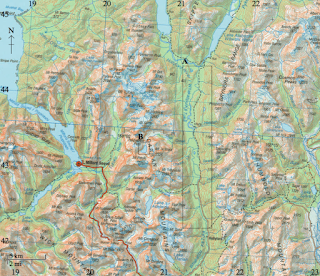
The map extract shows the area around Bekejo in Ethiopia. The scale of the map is 1:50 000. The contour interval is 20 metres.


5. (a) (i) Identify the vegetation types found at A and B.
A (Dega-Adi 9852) – Scrub.
B (Goro Faki 9646) – Scattered trees.
THESE TERMS ARE FOUND IN THE KEY
(ii) Using the map extract and key, suggest two reasons why the area shown could be considered an extreme environment. [2+2]
Likely reasons include the lava flows, the lack of settlement could be used as a surrogate for extreme conditions, seasonal rivers, disappearing streams, scattered trees, waterholes. Many of these suggest a seasonally wet-dry climate. A mark for each valid reason and an additional mark for the development of a factor in a way that is clearly linked with the inaccessible/inhospitable nature of extreme environments.
(b) Briefly explain two weathering processes likely to operate in area C on the map. [2+2]
Possibilities include exfoliation, granular and block disintegration, freeze-thaw, salt crystal growth, carbonation, oxidation, hydrolysis. Do not credit erosion processes such as sand abrasion. A mark for each process identified and a further mark for the brief explanation offered.
(c) For one named type of extreme environment, examine the impacts of tourism on
the natural environment. [10]
The impacts on the natural environment include mass movement, erosion, land degradation, hazards, aesthetic changes, water shortages (and salinisation), waste, introduction of exotic species, habitat removal. These can be positive/negative, short-term/long-term, intentional or unintentional.
Responses which deal with the human environment only cannot achieve above band C. To access band D, a named and located extreme environment should be addressed and candidates must examine the environmental impacts of tourism.
To access bands E and F, a variety of impacts should be examined.
6. (a) (i) Identify one type of cold extreme environment. [1]
Polar/glacial (equally acceptable)
Periglacial/tundra
Alpine/high mountains.
Do not accept regions, such as Arctic.
(ii) State three physical characteristics of the cold extreme environment that you identified in (a)(i). [3]
Exact answer will depend on the cold environment chosen. Credit three valid statements that can be linked to the example chosen in (a)(i).
Polar/glacial – year-round/permanent snow/ice / cold all year [1mark], extreme seasonality [1 mark], high latitudes above 65–70°N and some parts of the southern hemisphere [1 mark], limited biological activity but does have ecosystem eg polar bears [1 mark].
Periglacial/tundra – seasonal ground ice cover / fluctuating temperatures [1 mark], underlain by sporadic/discontinuous permafrost [1 mark], tundra biome eg low-lying perennials [1 mark], found on edges of polar/glacial areas/latitude 60–70°N [1 mark].
Alpine/high mountains in non-tropical latitudes – year-round/permanent snow/ice / cold all year due to altitude/snow line [1 mark], extreme diurnal temperature variations [1 mark], limited biological activity eg limit of tree-line but does have ecosystem eg alpine meadows [1 mark].
(b) Explain why semi-arid areas are considered to be extreme environments. [6]
Semi-arid environments are areas with 250–500 mm rain per year [1 mark] and suffer seasonal water shortages [1 mark]. Average temperatures are high (25°C upwards) for most of year [1 mark].
The remaining 3 marks should be allocated either for an in-depth explanation of these physical factors or for showing how they create challenges for resource development and human habitation. For instance, this creates difficulty maintaining sedentary agriculture as insufficient water supply without irrigation – and even then high evapotranspiration rates reduce effective water availability. Salinisation is a common problem where over-abstraction has taken place. Credit explanation that incorporates other factors such as remoteness, inaccessibility, relief.
(c) “Global climate change will prevent people from living in extreme environments.” Discuss this statement with reference to one or more extreme environments. [10]
Responses could deal with indigenous populations, settlements and/or economic activity in extreme environments (responses that do not deal with extreme environments should not progress beyond band C). Responses may argue that climate change will/will not have a major/minor impact on extreme environments. Some may argue that the impacts will vary from extreme environment to extreme environment. Some will examine the varying ability of different populations to adapt to change through technology.
To access band D, some impacts on people in extreme environments should be described.
To access bands E and F, responses must discuss both sides of the argument and draw conclusions.
November 2013
TABLE REMOVED DUE TO COPYRIGHT
5. (a) Referring to the table, describe four characteristics of the climate of Timbuktu. [4]
1 mark for each of four characteristics:
• temperatures are hot or warm all year
• maximum mean monthly temperature (34°C) is in May and June
• lowest average monthly temperatures are in December and January (22–23°C)
• annual rainfall is low/around 200 mm in total
• seasonality of rainfall – mostly in summer / there are five months with no rainfall
• May–July high temperatures suggest northern hemisphere climate
• high temperatures coincide with wetter season.
Cannot credit simple listing of monthly data. Maximum 3 marks if there is no quantification.
(b) With reference to a named hot, arid environment, explain two geographic factors (other than climate) that can make them extreme. [6]
Likely factors should include human discomfort, inaccessibility, remoteness and relief. (credit other valid factors, such as poor soils). 1 mark for each factor that is identified and a further 1 mark for the named example of a recognisable extreme arid environment.
The remaining 3 marks allocated for the explanation of the factors, for instance explaining how inaccessibility could limit development and habitation opportunities because tourism, or other forms of economic activity, cannot be easily implemented.
(c) Contrast the landforms that result from erosional and depositional glacial processes. [10]
The landforms could be contrasted in terms of shape, size, material, location and origin/formation, links to advance/retreat of ice.
Likely erosional features will include cirques, arête, pyramidal peaks, glacial troughs, hanging valleys, roche moutonnées and striations. Depositional features are likely to include till plains, moraines, kames, eskers, erratics and drumlins.
Erosional features are more likely to be located in upland areas, while depositional features are more commonly found in lowland areas. Erosional features are often formed of solid rock while depositional features are formed of unconsolidated material, whether sorted (fluvioglacial) or unsorted (glacial). Erosional features tend to be rugged, whereas depositional features are usually subdued with lower amplitude of relief.
To achieve band D, both erosion and deposition features should be covered and described with an attempt to contrast.
At band E and there should be a clear attempt at contrasting the features.
At band F, answers should show an awareness that many landforms owe their origin to a combination of erosional and depositional processes HENCE "CONTRAST".
6. (a) (i) Define the term aridity. [2]
Aridity refers to a lack of moisture [1 mark]. Further 1 mark for quantification (precipitation less than 250 mm), or a link with evapo-transpiration rates.
(ii) Define the term infertility. [2]
Infertility refers to the lack of nutrients/bases in soils [1 mark]. Further [1 mark] for recognition of lack of biomass; or low weathering rates/inputs of nutrients; partial decomposition; insufficient to supply plant-based agriculture/crops.
(b) Explain three factors, other than aridity and infertility, that affect the sustainability of human activities in extreme environments. [2+2+2]
The factors may either promote or reduce sustainability. Possible factors include population density (possibly leading to usage exceeding carrying capacity), changes to natural vegetation/habitat (likely to decrease carrying capacity), overuse (whether for agriculture, grazing, mining, tourism), the implementation of conservation measures, provision of irrigation (provided source of water is sustainable), etc. 1 mark for identifying/describing each valid factor and a further mark for development or exemplification.
(c) “Periglacial areas offer more opportunities for human activities than hot, arid areas.” Discuss this statement. [10]
Opportunities in both cases are widespread and include farming/cattle herding, mineral extraction, and tourism. Problems are likely to include climate, remoteness, and inaccessibility – as well as low temperatures in periglacial areas, as opposed to a lack of water in hot desert areas.
Opportunities could be for a range of players/stakeholders, including local people, TNCs/energy companies, tourists.
Answers should cover opportunities in both periglacial areas and hot, arid areas. The use of only one extreme environment which includes a range of opportunities is unlikely to progress beyond the D/E border.
To access band E both environments should be considered.
Band F expect detailed examples of opportunities in both environments and a clear conclusion.
May 2014

A – Glacial trough/U-shaped valley; will also accept truncated spurs, hanging valleys.
1 mark for the identification and another for a brief description of shape, size or appearance. For example, a glacial trough [1 mark] shown as a deep, straight valley [1 mark].
(ii) Identify and describe a landform of glacial erosion in area B on the map. [2]
B – Corrie/Cwm/Cirque. Accept corrie lake/tarn. LAKE IS NOT ACCEPTED.
1 mark for the identification and another for a brief description of shape, size or appearance of the landform. For example, a corrie lake [1 mark] which is about 1 km wide [1 mark].
(b) Using map evidence, suggest two reasons why the area shown on the map has a low population density. [3+3]
1 mark for a reason, 1 mark for map evidence and 1 mark for some development.
Reasons may include, but are not limited to:
• steep relief/gradients/rugged [1mark] so a challenge for economic activity/construction/settlement [1 mark] and identifies area of map using names or grid reference [1 mark]
• high relief/altitude [1 mark] leading to low temperatures / short growing season so less than optimum conditions for agriculture [1 mark] and identifies area of map using names or grid reference [1 mark]
• likely to be poor, thin soil [1 mark] due to mass wasting or gravity down slope [1 mark] and identifies area of map using names or grid reference [1 mark]
• inaccessibility/remoteness [1 mark] due to limited transportation [1 mark] and identifies area of map using names or grid reference [1 mark].
(c) “Mineral resources in extreme environments rarely bring benefits to the local people.” Discuss this statement. [10]
Some may argue benefits are not/rarely realized due to environmental challenges. Others may focus on the inequities of who benefits. Either approach is acceptable. A range of mineral deposits offer potential wealth to people in extreme environments (eg uranium, silver, gold, rare earths etc). However, there are physical challenges to resource exploitation eg, permafrost in cold environments or lack of transport infrastructure in sparsely populated arid areas. Indigenous people may lack the technology to overcome challenges so outsiders/TNCs gain some/most benefits. However, there may still be gains for local people. Potential benefits include more employment, higher wages, investment, health care and infrastructural improvements.
Another approach might be to argue that minerals bring problems not benefits. Problems could include dependency on benefits among indigenous people, conflict with economic migrants, leakage of money overseas (remittances), possible environmental pollution, conflict over scarce resources (water and land) in arid areas. The environment and local society may no longer be sustainable as a result of mineral exploitation. Tropical rainforests are not considered.
Band D responses are likely to be descriptive accounts of the benefits local people could gain/do not gain. Alternatively, a simple account is given of why local people do not gain benefits.
Band E expects either a more detailed account of the mineral resources found in extreme environments and the benefits they bring / do not bring to local people/others or an evaluation of who benefits most from mineral resources (carefully weighs up the benefits for local people and TNCs, for example).
Band F expects both.
6. (a) (i) Define the term desertification. [1]
The spread/intensification of desert/arid conditions. Alternative phrasing will also be credited if it implies change, such as turning/becoming eg “the desert has expanded”.

1 mark for each of the following to a maximum of 3 marks:
• adjacent to existing deserts
• identification of anomalies eg, Western Australia
• limited to central and western Australia (not east)
• reference to place names/tropics/latitude.
(b) Suggest three reasons why some rainstorms in hot, arid environments result in flash floods. [2+2+2]
1 mark for each reason and another for a suggested link with flooding. Reasons could include:
• torrential precipitation [1 mark] leads to overland flow/surface water [1 mark]
• precipitation exceeds infiltration rate [1 mark] thereby causing overland flow [1 mark]
• sparse vegetation leads to less interception [1 mark] and rapid run-off/less storage [1 mark]
• run-off may be rapidly concentrated in wadis and canyons [1 mark] which overflow [1 mark]
• nature of desert surfaces (crusts, rocky, impermeable) [1 mark] also causing rapid run-off [1 mark].
Maximum of 4 marks if the reasons do not clearly relate to flash floods in an arid environment, as opposed to generic flooding.
(c) Examine how human activity may be affected by global climate change in one named extreme environment you have studied. [10]
You may choose to approach this question in terms of current observable changes or predicted change. Either approach is acceptable.
In cold environments, melting permafrost may give benefits or costs. Benefits could include longer growing seasons, potential for sedentary agriculture, potential for commercial forestry, more rainfall in cold environments, more potential for tourism, and increased accessibility of minerals. There may also be less, but unpredictable sea ice making sea routes more accessible but potentially more hazardous / increased fish availability due to changing sea conditions (increasing fishing potential).
Problems could include traditional ways of life based on hunting and fishing are threatened; out-migration of the younger people, unstable buildings and infrastructure.
Possible loss of snow and its impact on ski resorts in mountainous areas, and the loss of water supply from retreating glaciers, impacting on a range of human activities, is also a valid response.
In hot environments: changes in rainfall patterns may give benefits or costs, benefits may lead to better grazing potential, more food production and more reliable water supplies. Lower rainfall could make marginal land impossible to live on as grass disappears and fuel wood becomes limited. Rainfall patterns could become more extreme, either more flash floods or extreme droughts. Food shortages may become more frequent/intense leading to environmental migration.
Credit given for an evaluation that takes a considered view of how wealthy people in extreme environments may be in a better position to adapt to change eg, water management in Dubai.
Again, tropical rainforests don't count.
Band D expects some description of two ways in which human activity may be affected by climate change in a recognisable extreme environment.
Band E expects either a more detailed account of a greater range of impacts, or some explicit evaluation of a variety of different kinds of impact (positive/negative or short-term/long-term).
Band F expects both.
November 2014

Butte, cliff, plateau, pediment, plain, scree/talus slope, mesa.
(ii) Suggest how landform B in the photograph was formed. [3]
You need to show a basic understanding of the weathering and erosional processes in arid extreme environments should be demonstrated. Landform (butte) need not be named. If an incorrect landform is identified in part (i) (such as a zeugen), a maximum of 2 marks. WIND EROSION DOESN'T COUNT.
1 MARK for each of the following suggestions:
• original land surface was eroded by backwearing/slope retreat
• a specific weathering process has played a role (eg heating and cooling, or
freeze-thaw), or erosion by water
• sloping talus layer is produced by mass movement.
(b) Explain two environmental impacts of tourism on one named extreme environment. [3+3]
In each case, 1 mark for each identified environmental impact linked to a tourist activity and 2 marks for further development and explanation of how the physical environment is affected.
Possibilities include erosion, mass movement, land degradation, vulnerability to hazards, water usage, waste disposal, disruption to biodiversity. Positive changes are possible eg irrigation, restoration.
For example: “Erosion of land surface by off-road vehicles [1 mark]. This destroys what little vegetation helps bind the soil together in semi-arid areas [1 mark] which can then contribute to desertification [1 mark].”
Maximum 3 marks for a generic account of tourism impacts with no reference to the specifics of a named extreme environment.
(c) Contrast the challenges for mineral extraction in periglacial environments and hot, arid environments. [10]
The challenges for mineral extraction in periglacial areas include low temperatures, seasonal lack of daylight, permafrost, thermokarst, remoteness, inaccessibility, water supply, transport difficulties, environmental conservation, attracting and retaining workforce.
Challenges in hot, arid areas include the high temperatures, lack of water, dust and sandstorms, remoteness, inaccessibility, attracting and retaining workforce, environmental conservation and transport difficulties.
Remoteness, inaccessibility and the challenge of attracting a workforce are features that can be described in relation to either environment. However, good answers will seek contrasts (such as inaccessibility due to low numbers of tundra travel days, linked with active layer thawing, as opposed to mobile dunes in arid areas).
For band D you must describe some challenges found in periglacial and arid areas (all of the above list are not necessary), with some basic link to mineral extraction established, rather than all human activity in general. Contrasts are not expected to be made explicit at this level.
Band E should either provide greater detail of how specific challenges for mineral extraction arise in both cases, or can offer a strongly contrasting account of the two extreme environments.
Band F expects both elements.
6. (a) From information shown on the graph:

Six months [1 mark]
(ii) Estimate the annual temperature range in °C. [1]
28 to 30 inclusive, or a range of -13°C (or -14°C) to +16°C
(iii) Apart from temperature, outline one other climatic characteristic shown on the graph that indicates Arkhangelsk is located in an extreme environment. [2]
1 mark for one of the following:
• identifies no sunshine in December and January
• the number of wet days is high (over 20 in 4 months of the year)
• relatively low precipitation throughout the year.
Another mark for outlining an implication for people or the environment that shows why this can be regarded as extreme.
For example: “There is no sunshine in December [1 mark], which means even evergreen plants cannot photosynthesise at all [1 mark].”
(b) Explain three ways in which people have adapted to the extremes of weather and climate in periglacial areas such as Arkhangelsk. [2+2+2]
1 mark for each adaptation and a further mark for an explanation that links this with periglacial weather and climate (should be specific about season, and not generalised).
If more than three adaptations are considered, only the first three accepted.
A variety of responses are possible at different scales from individual to communities within a large urban area:
• clothing needs to be wind proof/insulated/layered [1 mark] as strong winds contribute to wind chill in winter months [1 mark]
• cars having extra heaters [1 mark] to stop diesel fuel freezing due to extreme cold in winter [1 mark]
• buildings on stilts [1 mark] to avoid potential issues with permafrost thaw in summer [1 mark]
• clearance of snow on roads / gritting of roads [1 mark] during winter months snow and long periods of ice on roads [1 mark]
• extra use of lighting to work [1 mark] during winter when daylight is limited/absent [1 mark]
• some people may take vitamin D supplements [1 mark] in winter to make up for a lack of sunshine [1 mark]
• costs of adapting to such a wide range of conditions [1 mark] eg winter and summer clothing [1 mark].
For a simple list of “cold” adaptations a maximum of 3 marks awarded.
(c) “Desertification is the main environmental risk for agriculture in hot deserts and semi-arid areas.” Discuss this statement, with reference to examples. [10]
Desertification is the extensification or intensification of desert conditions and a major risk in many parts of the world today. Other environmental risks include salinisation, flash floods, and saline intrusions. Some risks are linked (eg desertification could encourage irrigation and trigger salinisation).
There are a number of ways to discuss the statement. One way is to compare desertification with the severity of other risks eg salinisation. Another way is to discuss how the risk of desertification varies according to climate and wealth of different countries (eg Sahel and Gulf states), or between hot deserts and semi-arid areas.
For Band D, describe the risk to agriculture of desertification and/or another environmental threat for named arid/semi-arid area(s) (may not distinguish at this level).
Band E should either provide much greater detail of how desertification affects agriculture in different areas (may contrast hot deserts and semi-arid areas) or evaluates the severity of at least one additional risk, such as salinisation.
Band F expects both elements.
May 2015

Wind/Aeolian (or abrasion) [1]. Softer rock strata are removed by sand blasting/abrasion [1] leaving the more resistant layers.
(ii) Identify and explain the formation of one water-formed feature commonly found in a hot, arid environment. [4]
1 mark for identification of any valid water-formed feature eg wadi, mesa, butte, canyon, inselberg, pediment, alluvial fan / bahada, salt lake / playa.
NOT OASIS.
Another mark for a valid description or sketch of the landform if provided and up to 3 marks for a valid explanation.
For example, wadi [1]. A dry, steep-sided river bed [1] formed by water erosion/downcutting through the rock layers [1]. Flash floods/ephemeral streams have high energy [1].
(b) Explain how two factors (other than heat) restrict human settlement in hot, arid environments. [2+2]
1 mark for each factor and a further mark for a link to human settlement.
For example, remoteness [1] means that it is very difficult to provide services to people [1].
Possible factors include: inaccessibility, remoteness, lack of water, possibility of salinisation with irrigation, perceived infertility of soils, increasing desertification.
(c) “Some human activities in extreme environments are more sustainable than others.”
Discuss this statement, with reference to one or more types of extreme environment. [10]
May either look at a range of activities in one extreme environment or a narrower range of activities across two or more extreme environments.
Extreme environments are generally considered to be very fragile environments and largely inhospitable. However, they do provide numerous opportunities for economic activities (mining, tourism, agriculture), settlement, etc.
Possible themes include:
• in cold environments, governments have to carefully balance economic and environmental agendas, eg the state of Alaska has to balance the energy needs of the USA (further exploration and production) with the requirement for conservation and environmental management
• possible conflicts may exist between tourism, wildlife movement and the transport of oil; or with the fragility of the permafrost (insulation, oil infrastructure)
• in arid environments, the focus of sustainability could be agriculture or mineral extraction, eg uranium extraction in Niger
• tourism in alpine areas.
Go beyond simply agreeing or rejecting the statement to discuss the validity of the statement with reference to different strands of sustainability (economic/social/environmental). Another approach might be to discuss how sustainability could be dependent on factors other than environmental challenges, such as access to capital (for irrigation, air conditioning etc).
For band D, provide some description of the impacts of human activity in one or more extreme environments (sustainability may not be explicit).
At band E, provide either more detailed explanation of the sustainability/impacts of human activities in one or more extreme environments or a structured discussion of what is meant by sustainability in this context.
Band F expects both of these elements.
6. (a) (i) State and locate one example of mineral extraction in an extreme environment. [2]
1 mark for identification of a mineral and another for valid location.
Possibilities include: oil in Alaska / gas in Siberia / uranium mining in Niger / copper mining in the Atacama desert / oil in Saudi Arabia.
(ii) Outline one economic reason why the mineral identified in (a)(i) is extracted in this extreme environment. [2]
1 mark for identifying a reason, eg market value or local job creation and another for further outlining.
For example: “Declining world reserves of oil [1] have made prices very high [1]”, or “extreme environments lack many employment opportunities [1] due to low density population [1]”.
(b) Explain two physical challenges for resource development posed by extreme
environments. [3+3]
In each case 1 mark awarded for identifying the challenge and 2 marks for development. One or more extreme environments may be used (no penalty for using only one).
Both periglacial and hot, arid environments are acceptable.
You may focus on mining and/or associated settlement and communications. Challenges include climatic factors, other physical characteristics, remoteness, inaccessibility, inhospitable living conditions, specific characteristics for area or example chosen.
(c) Examine why desertification has become a problem in some parts of the world. [10] Desertification is an environmental issue resulting from pressure on resources.
You need to show knowledge of the causes of desertification: social, political, economic, and climatic factors (infrequent or irregular rainfall, overgrazing, over-cultivation, deforestation, poor irrigation, over-population etc).
The problems/consequences could be environmental, economic, or social (for example, poor vegetation growth, damaged soils, vulnerability to soil erosion, reduced land available for crops and pasture, expanding sand dunes, reduced income, increased rural poverty, reliance on food aid, forced migration).
There is the opportunity to discuss strategies to prevent desertification (managing land use and livestock, managing water usage, afforestation, population control, availability of capital).
Good answers may examine reasons why some parts rather than others have been affected despite similar climatic conditions regions (may examine different degrees of problem or challenge and/or include the uneven success of management). Another approach might be to carefully structure an answer to highlight different types of problem, or different groups/stakeholders/perspectives who are adversely affected (or not). Another approach might be to examine/synthesise how a range of factors combine to trigger desertification.
For band D, provide some description of some problems/causes associated with desertification (may assert the problem is getting worse).
Band E expects either more detailed explanation of the causes of desertification in particular places or a structured examination of different kinds of problem/places.
Band F expects both of these elements.